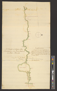
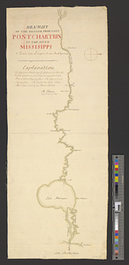
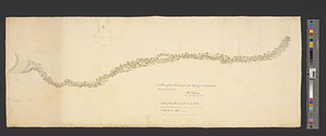
A plan of the Ibberville from the Missisippi to Anatamaha
This map is also available in American Revolutionary Geographies Online (ARGO), a collections portal especially built for material relating to the American Revolutionary War Era. Visit ARGO to learn more about this item and explore the historical geography of North America in the late eighteenth century.
Item Information
- Title:
- A plan of the Ibberville from the Missisippi to Anatamaha
- Creator:
- Pittman, Philip, active 1760-1770
- Name on Item:
-
survey'd and drawn by Ph: Pittman, lieut. of 15th Regt. asst. engr.
- Date:
-
[1765]
- Format:
-
Maps/Atlases
- Genre:
-
Manuscript maps
- Location:
- William L. Clements Library
- Collection (local):
-
William L. Clements Library Collection
- Subjects:
-
Manchac, Bayou (La.)--Maps
- Places:
-
LouisianaManchac, Bayou (stream)
- Extent:
- 1 ms. map : col. ; 24.3 x 61.3 cm.
- Terms of Use:
-
The University of Michigan Library provides access to these materials for educational and research purposes. These materials may be under copyright. If you decide to use any of these materials, you are responsible for making your own legal assessment and securing any necessary permission. If you have questions about the collection, please contact the William L. Clements Library.
Contact host institution for more information.
- Scale:
-
Scale 1:24,000.
- Language:
-
English
- Catalog Record:
-
Catalog record
- Notes:
-
Finished, colored, topographical strip map of the Iberville River.
Enclosed, with several other maps, in Pittman to Gage of 27 March 1765.
Widths of the stream given at four locations and other notations provide comments about navigating the river.
- Notes (date):
-
This date is inferred.
- Identifier:
-
1670
- Barcode:
-
B3315768