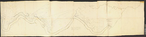
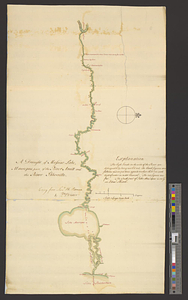
The communication between the Iberville and the river Mississippe

This map is also available in American Revolutionary Geographies Online (ARGO), a collections portal especially built for material relating to the American Revolutionary War Era. Visit ARGO to learn more about this item and explore the historical geography of North America in the late eighteenth century.
Item Information
- Title:
- The communication between the Iberville and the river Mississippe
- Contributor:
- Robertson, Archibald, approximately 1745-1813
- Contributor:
- Fraser, Alexander
- Creator:
- Durnford, Elias, 1739-1794
- Date:
-
[1770]
- Format:
-
Maps/Atlases
- Genre:
-
Manuscript maps
- Location:
- William L. Clements Library
- Collection (local):
-
William L. Clements Library Collection
- Subjects:
-
Manchac, Bayou (La.)--Maps
Mississippi River--Maps
- Places:
-
LouisianaManchac, Bayou (stream)
Mississippi River
- Extent:
- 1 ms. map ; 38.9 x 47 cm
- Terms of Use:
-
The University of Michigan Library provides access to these materials for educational and research purposes. These materials may be under copyright. If you decide to use any of these materials, you are responsible for making your own legal assessment and securing any necessary permission. If you have questions about the collection, please contact the William L. Clements Library.
Contact host institution for more information.
- Scale:
-
Scale 1:63,360.
- Language:
-
English
- Catalog Record:
-
Catalog record
- Notes:
-
Enclosed in letter to Gage, May 4, 1770.
Pen and ink outline map showing the course of the Mississippi in the area where it is joined by the Iberville River, the boundary between British West Florida and Spanish Louisiana.
Identifies location of Fort Bute, built in 1765 and abandoned in 1768.
Extensive remarks provide sources of cartographic information and describe the rivers.
- Notes (date):
-
This date is inferred.
- Identifier:
-
5575
- Barcode:
-
B1938959