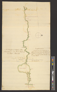
Plan of the river Mississippi from the Indian village of the Tonicas to the river Ibberville, shewing the lands surveyed thereon as also the rivers Ibberville, Amit, and Comit, with the situation of the new town proposed at the Ibberville
This map is also available in American Revolutionary Geographies Online (ARGO), a collections portal especially built for material relating to the American Revolutionary War Era. Visit ARGO to learn more about this item and explore the historical geography of North America in the late eighteenth century.
Item Information
- Title:
- Plan of the river Mississippi from the Indian village of the Tonicas to the river Ibberville, shewing the lands surveyed thereon as also the rivers Ibberville, Amit, and Comit, with the situation of the new town proposed at the Ibberville
- Title (alt.):
-
Plan of the Mississippi from Point Coupée to the Iberville, & from thence to the Lake Maurepas
- Contributor:
- Hutchins, Thomas, 1730-1789
- Creator:
- Durnford, Elias, 1739-1794
- Name on Item:
-
a true copy from Enginr. Durnford by Tho. Hutchins
- Date:
-
[ca. 1773]
- Format:
-
Maps/Atlases
- Genre:
-
Manuscript maps
- Location:
- William L. Clements Library
- Collection (local):
-
William L. Clements Library Collection
- Subjects:
-
Real property--Louisiana--Maps
Mississippi River--Maps
Manchac, Bayou (La.)--Maps
Amite River (La.)--Maps
- Places:
-
Mississippi River
LouisianaManchac, Bayou (stream)
LouisianaAmite (river)
- Extent:
- 1 ms. map : col. ; 76 x 297 cm. with extension of river Iberville of 40 x 49 cm.
- Terms of Use:
-
The University of Michigan Library provides access to these materials for educational and research purposes. These materials may be under copyright. If you decide to use any of these materials, you are responsible for making your own legal assessment and securing any necessary permission. If you have questions about the collection, please contact the William L. Clements Library.
Contact host institution for more information.
- Scale:
-
Scale 1:32,000.
- Language:
-
English
- Catalog Record:
-
Catalog record
- Notes:
-
Finished, colored topographical map showing surveyed parcels and a proposed plan for a new town just to the north of the site of the former Fort Bute at the mouth of the Iberville River.
No names of grant holders are given except for those of Governor George Johnstone and Lt. Governor Montfort Brown.
See the Report of Lieut. Thomas Hutchins acting engineer in consequence of General Gage's instructions dated Pensacola 1 May 1773 for a description of the area.
For a further discussion, see Hutchins, An historical narrative and topographical description of Louisiana and West Florida... Philadelphia. 1784.
- Identifier:
-
8339
- Barcode:
-
B3311286