Map of the United States and their territory

This map is also available in American Revolutionary Geographies Online (ARGO), a collections portal especially built for material relating to the American Revolutionary War Era. Visit ARGO to learn more about this item and explore the historical geography of North America in the late eighteenth century.
Item Information
- Title:
- Map of the United States and their territory
- Creator:
- Millin, J. M.
- Name on Item:
-
J.M. Millin, Oct. 1804
- Date:
-
October 1804
- Format:
-
Maps/Atlases
- Genre:
-
Manuscript maps
- Location:
- William L. Clements Library
- Collection (local):
-
William L. Clements Library Collection
- Subjects:
-
Indians of North America--Maps
Southern States--Maps
- Places:
-
Southern United States (area)
- Extent:
- 1 ms. map ; 32 x 40 cm.
- Terms of Use:
-
The University of Michigan Library provides access to these materials for educational and research purposes. These materials may be under copyright. If you decide to use any of these materials, you are responsible for making your own legal assessment and securing any necessary permission. If you have questions about the collection, please contact the William L. Clements Library.
Contact host institution for more information.
- Scale:
-
Scale indeterminate.
- Language:
-
English
- Catalog Record:
-
Catalog record
- Notes:
-
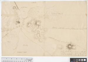
Pen and ink and pencil map of the southeastern part of the United States.
Shows extent of Indian claims with locations of Indian towns.
On verso: draft claim in land dispute from Paris, Kentucky, ca. 1790 concerning John Tabb and Philemon Thomas.
- Identifier:
-
6351
- Barcode:
-
B3668446


![A map of West Florida and part of Et: Florida, Georgia part of So: Carolina i[n]cluding [torn] & Chactaw, Chickasaw & Creek nations with [torn] [r]oad [torn] Pensacola through ye: Creek nation to Augusitus & Charlestown](https://bpldcassets.blob.core.windows.net/derivatives/metadata/commonwealth-oai:v98001375/image_thumbnail_300.jpg)
