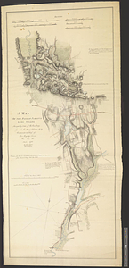
A map of the pass at Jamaica, Long Island : surveyed by order of his excellency General Sir Henry Clinton K:B: commander in chief of his majesty's forces &ca, &ca, &ca, March 1782
This map is also available in American Revolutionary Geographies Online (ARGO), a collections portal especially built for material relating to the American Revolutionary War Era. Visit ARGO to learn more about this item and explore the historical geography of North America in the late eighteenth century.
Item Information
- Title:
- A map of the pass at Jamaica, Long Island : surveyed by order of his excellency General Sir Henry Clinton K:B: commander in chief of his majesty's forces &ca, &ca, &ca, March 1782
- Creator:
- Taylor, George (Geographer), active 1778
- Name on Item:
-
by George Taylor, capt: of Guides
- Date:
-
March 1782
- Format:
-
Maps/Atlases
- Genre:
-
Manuscript maps
- Location:
- William L. Clements Library
- Collection (local):
-
William L. Clements Library Collection
- Subjects:
-
Jamaica (New York, N.Y.)--Maps
United States--History--Revolution, 1775-1783--Maps
- Places:
-
New YorkNew YorkJamaica
- Extent:
- 1 ms. map : col. ; 153.5 x 68 cm.
- Terms of Use:
-
The University of Michigan Library provides access to these materials for educational and research purposes. These materials may be under copyright. If you decide to use any of these materials, you are responsible for making your own legal assessment and securing any necessary permission. If you have questions about the collection, please contact the William L. Clements Library.
Contact host institution for more information.
- Scale:
-
Scale 1:7,200.
- Language:
-
English
- Catalog Record:
-
Catalog record
- Notes:
-
A finished, colored, topographical map showing positions of British troops and indicating points of artillery placement with the range of the guns.
Five inset sections give land elevations at specific points.
Notations provide additional information.
Individual houses are shown, many with the names of owners.
Clinton Map 124.
- Identifier:
-
8673
- Barcode:
-
B2819646


