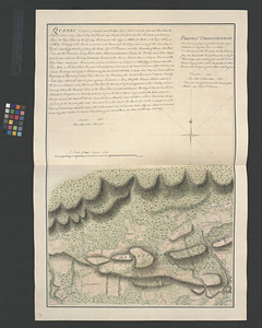
A plan of the Palace Barracks at Quebec with the environs, relative to a report of this date and an estimate of the expence of the repairs humbly thought necessary for the year 1772
This map is also available in American Revolutionary Geographies Online (ARGO), a collections portal especially built for material relating to the American Revolutionary War Era. Visit ARGO to learn more about this item and explore the historical geography of North America in the late eighteenth century.
Item Information
- Title:
- A plan of the Palace Barracks at Quebec with the environs, relative to a report of this date and an estimate of the expence of the repairs humbly thought necessary for the year 1772
- Title (alt.):
-
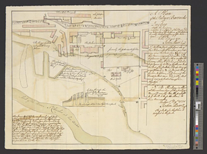
Section through the projected ballerdeau [sic] for this new wood yard
- Creator:
- Marr, John
- Date:
-
August 1, 1771
- Format:
-
Maps/Atlases
- Genre:
-
Manuscript maps
- Location:
- William L. Clements Library
- Collection (local):
-
William L. Clements Library Collection
- Subjects:
-
Barracks--Québec (Province)--Québec--Maps
Québec (Québec)--Maps
- Places:
-
CanadaQuebec (province)Québec
- Extent:
- 1 ms. map : col. ; 36.5 x 46 cm
- Terms of Use:
-
The University of Michigan Library provides access to these materials for educational and research purposes. These materials may be under copyright. If you decide to use any of these materials, you are responsible for making your own legal assessment and securing any necessary permission. If you have questions about the collection, please contact the William L. Clements Library.
Contact host institution for more information.
- Scale:
-
Scale for plan 1:1,200 and for section 1:72.
- Language:
-
English
- Catalog Record:
-
Catalog record
- Notes:
-
Finished, colored topographical map showing existing and projected buildings of the barracks complex.
Signed: John Marr engr.
Enclosed in Marr to Gage, August 15, 1771 with report.
- Identifier:
-
8321
- Barcode:
-
B1937672