Toggle navigation
LMEC Home
Exhibitions
Georeferencing
Tools for Teachers
Collections
My Favorites
Sign Up / Log In
Search
Search the map portal
Map Collection
Map Collection
Map Sets
Search
Search
Search for
Search In
All Fields
Creator
Title
Subject
Place
Search All Digital Collections
Advanced Search
460 Results
My Search
Start Over
Date
1700
to
1749
Remove constraint Date: <span class='from'>1700</span> to <span class='to'>1749</span>
Filter your Search
Place
North and Central America
272
United States
116
Europe
69
Canada
64
North America
53
South America
48
Africa
39
France
22
more
Place
»
Topic
North America--Maps--Early works to 1800
29
Manuscript maps--Early works to 1800
24
America--Maps--Early works to 1800
19
Western Hemisphere--Maps--Early works to 1800
19
South America--Maps--Early works to 1800
16
Louisbourg (N.S.)--Maps, Manuscript--Early works to 1800
14
Louisbourg (N.S.)--History--Siege, 1745--Maps, Manuscript--Early works to 1800
13
West Indies--Maps--Early works to 1800
12
more
Topic
»
Date
1700
to
1749
[remove]
460
Date range begin
–
Date range end
Current results range from
1668
to
1800
1700
to
1704
53
1705
to
1709
50
1710
to
1714
57
1715
to
1719
50
1720
to
1724
59
1725
to
1729
44
1730
to
1734
75
1735
to
1739
90
1740
to
1744
77
1745
to
1749
125
Creator
Moll, Herman, d. 1732
60
George, III, King of Great Britain, 1738-1820
40
George, IV, King of Great Britain, 1762-1830
39
L'Isle, Guillaume de, 1675-1726
25
Bellin, Jacques Nicolas, 1703-1772
17
Royal United Services Institute for Defence and Security Studies
17
Bastide, John Henry, approximately 1700-1770
15
Bowles, John, 1701-1779
14
more
Creator
»
Format
Maps/Atlases
451
Manuscripts
70
Drawings/Illustrations
5
Prints
3
Georeferenced
Yes
25
No
435
Collection
Norman B. Leventhal Map & Education Center Collection
300
American Revolutionary War-Era Maps
129
British Library Collection
73
Maritime Charts and Atlases
46
Boston and New England Maps
33
William L. Clements Library Collection
28
Newberry Library Collection
22
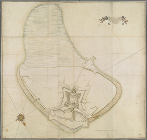
Urban Maps
17
more
Collection
»
Available to use
No known restrictions
296
Creative Commons license
102
Search Constraints
Sort by relevance
relevance
title
date (asc)
date (desc)
Number of results to display per page
20 per page
10
per page
20
per page
50
per page
100
per page
View results as:
grid view
map view
Search Results
161.
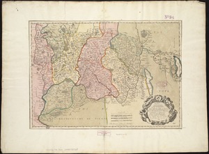
Generalis Lotharingiae Ducatus Tabula, qua accuratissime oftenduntur Ducatus Lotharingiae Propriae et Barrensis nec non...
162.
A generall chart of the western ocean
163.
Gezigt van Porto Grande, in 't eiland St. Vincent = Vüe de Porto Grande dans l'ile de St. Vincent
164.
Grand theatre de la guerre en Amerique suivant les plus nouvelles observations des Espagnols, Anglois, François & Hollandois
165.
Grondtekening van de stad en forten van St. Iago = Plan de la ville et des forts de St. Yago
166.
Grundriss der stadt und der forts von St. Jago od. Jacob
167.
Grundriss von der bay der insel St. Vincent einer von den Eylanden des grünen Vorgebirges
168.
The Gulf coast from the Mississippi Delta to the Bay of St. Joseph
169.
Habitation de l'autheur sur le fleuve
170.
Harbor Grace
171.
The harbour of Casco Bay and islands adjacent
172.
The harbour of Casco Bay and islands adjacent
173.
An historical map of the Roman Empire and the neighbouring barbarous nations to the year of our Lord four hundred when the...
174.
The ICHNOGRAPHY of CHARLES-TOWN, at High Water
175.
The Icqnographical draft of Castle Island where upon is built Her Maj.ties Castle and by Her Maj.ties Special Command named...
176.
In notitiam ecclesiasticam Africæ tabula geographica
177.
Insubres in Segusianis : partie du dioecese, et Archevesché de Lyon : partie méridionale de la Bresse du Bugey, et Valromey,...
178.
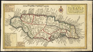
Insula Iamaica : in suas parochias divisa et secundum exemplar primitivum Londinense excusa
179.
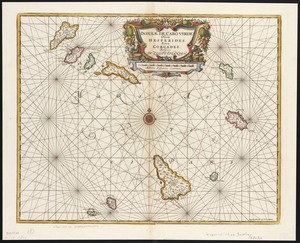
Insulae de Cabo Verde, Olim Hesperides, sive Gorgades : Belgice de zoute eylanden
180.
The island of Antego
‹ Prev
Next ›
1
2
…
5
6
7
8
9
10
11
12
13
…
22
23