Toggle navigation
LMEC Home
Exhibitions
Georeferencing
Tools for Teachers
Collections
My Favorites
Sign Up / Log In
Search
Search the map portal
Map Collection
Map Collection
Map Sets
Search
Search
Search for
Search In
All Fields
Creator
Title
Subject
Place
Search All Digital Collections
Advanced Search
13680 Results
My Search
Start Over
Filter your Search
Place
North and Central America
10,344
United States
8,475
Massachusetts
2,789
Suffolk (county)
1,677
Boston
1,633
Europe
1,415
Canada
950
New York
649
more
Place
»
Topic
Boston (Mass.)--Maps
747
City planning--Massachusetts--Boston--Maps
418
United States--History--Revolution, 1775-1783--Maps
329
United States--Maps
322
Real property--Massachusetts--Boston--Maps
254
Urban renewal--Massachusetts--Boston--Maps
254
Massachusetts--Maps
231
Insurance surveys
197
more
Topic
»
Date
Date range begin
–
Date range end
Current results range from
1482
to
2023
View distribution
Creator
United States. Hydrographic Office
597
Boston Redevelopment Authority
404
Des Barres, Joseph F. W. (Joseph Frederick Wallet), 1722-1824
247
Royal United Services Institute for Defence and Security Studies
160
Jefferys, Thomas, -1771
154
George, III, King of Great Britain, 1738-1820
152
George, IV, King of Great Britain, 1762-1830
151
O.H. Bailey & Co
148
more
Creator
»
Format
Maps/Atlases
13,499
Manuscripts
985
Prints
102
Books
49
Drawings/Illustrations
44
Photographs
15
Objects/Artifacts
13
Documents
7
more
Format
»
Georeferenced
Yes
979
No
12,701
Collection
Norman B. Leventhal Map & Education Center Collection
9,096
American Revolutionary War-Era Maps
3,305
Boston and New England Maps
2,915
Urban Maps
2,471
Maritime Charts and Atlases
1,169
William L. Clements Library Collection
910
Library of Congress Collection
618
Boston Redevelopment Authority Collection
475
more
Collection
»
Available to use
No known restrictions
10,246
Creative Commons license
1,678
Search Constraints
Sort by relevance
relevance
title
date (asc)
date (desc)
Number of results to display per page
20 per page
10
per page
20
per page
50
per page
100
per page
View results as:
grid view
map view
Search Results
1541.
Canada, Louisiane et terres angloises
1542.
Canada, Louisiane et terres angloises
1543.
Canada orientale nell' America Settentrionale
1544.
Le Canada, ou Nouvelle France, &c : ce qui est le plus advance vers le Septentrion est tiré de diverses relations des Anglois,...
1545.
Le Canada, ou Nouvelle France, la Floride, la Virginie, Pensilvanie, Caroline, Nouvelle Angleterre et Nouvelle Yorck, l'Isle de...
1546.
Canadian Rockies showing main line of Canadian Pacific Ry. with branch lines & steamship connections
1547.
The Canadian west
1548.
Canal du Cap-Cod : plan général du tracé du canal
1549.
The Canary Islands : from British surveys in 1834 and 1838 corrected to 1871
1550.
Canary Islands, Tenerife, Santa Cruz
1551.
Cannonade at Pass Krug, 3d. October 1758
1552.
Canobie Lake Park, Salem N.H.
1553.
A canoeist's guide to New England's rivers
1554.
Canso Harbor
1555.
Canso Harbor
1556.
Canso Harbor
1557.
Cantium vernacule Kent
1558.
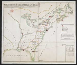
Cantonment of His Majesty's forces in N. America : according to the disposition now made & to be compleated as soon as...
1559.
CANTONMENT of HIS MAJESTY'S FORCES in N. AMERICA ACCORDING TO THE DISPOSITION NOW MADE & TO BE COMPLETED AS SOON AS PRACTICABLE...
1560.
Cantonment of the forces in N. America 1766
‹ Prev
Next ›
1
2
…
74
75
76
77
78
79
80
81
82
…
683
684