Toggle navigation
LMEC Home
Exhibitions
Georeferencing
Tools for Teachers
Collections
My Favorites
Sign Up / Log In
Search
Search the map portal
Map Collection
Map Collection
Map Sets
Search
Search
Search for
Search In
All Fields
Creator
Title
Subject
Place
Search All Digital Collections
Advanced Search
14164 Results
Filter your Search
Place
North and Central America
10,811
United States
8,818
Massachusetts
2,820
Suffolk (county)
1,688
Boston
1,644
Europe
1,428
Canada
1,010
New York
683
more
Place
»
Topic
Boston (Mass.)--Maps
753
City planning--Massachusetts--Boston--Maps
419
United States--History--Revolution, 1775-1783--Maps
331
United States--Maps
331
Real property--Massachusetts--Boston--Maps
254
Urban renewal--Massachusetts--Boston--Maps
254
North America--Maps--Early works to 1800
241
Massachusetts--Maps
236
more
Topic
»
Date
Date range begin
–
Date range end
Current results range from
1482
to
2023
View distribution
Creator
United States. Hydrographic Office
597
Boston Redevelopment Authority
404
Des Barres, Joseph F. W. (Joseph Frederick Wallet), 1722-1824
247
Jefferys, Thomas, -1771
172
United States. National Ocean Service
170
Royal United Services Institute for Defence and Security Studies
160
George, III, King of Great Britain, 1738-1820
152
George, IV, King of Great Britain, 1762-1830
151
more
Creator
»
Format
Maps/Atlases
13,978
Manuscripts
985
Prints
102
Books
53
Drawings/Illustrations
44
Photographs
15
Objects/Artifacts
13
Documents
7
more
Format
»
Georeferenced
Yes
979
No
13,185
Collection
Norman B. Leventhal Map & Education Center Collection
9,162
American Revolutionary War-Era Maps
3,629
Boston and New England Maps
2,936
Urban Maps
2,511
Maritime Charts and Atlases
1,169
William L. Clements Library Collection
910
Library of Congress Collection
618
Boston Redevelopment Authority Collection
475
more
Collection
»
Available to use
No known restrictions
10,408
Creative Commons license
1,678
Search Constraints
Sort by relevance
relevance
title
date (asc)
date (desc)
Number of results to display per page
20 per page
10
per page
20
per page
50
per page
100
per page
View results as:
grid view
map view
Search Results
13341.
Türkei und Griechenland
13342.
Turkestan and the countries between the British and the Russian dominions in Asia : mapped on the basis of the surveys made by...
13343.
Turkestan and the countries between the British and the Russian dominions in Asia : mapped on the basis of the surveys made by...
13344.
Turkey
13345.
Turkey, in Europe and Hungary : from the best authorities
13346.
Turkey in Europe, from the latest authorities
13347.
The Turkish Empire, comprising the Caucasian isthmus, with the adjoining countries, forming a complete map of the present seat...
13348.
The Turkish Empire in Europe, Asia and Africa, dividid into all its governments, together with the other territories that are...
13349.
Turkish-Allies operations, European war
13350.
Turners Falls, Mass : 1877
13351.
The turnings of the River Forth with ye adjacent County of Clackmanan & part of Stirling shire
13352.
Turquie d'Europe
13353.
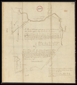
Twentieth century Boston
13354.
Twenty years of change on the Massachusetts coastline : maps and statistics, 1951-1971
13355.
Two miles around the pendulum station on Hoosac Mountain near central shaft of tunnel, Massachusetts, 1874
13356.
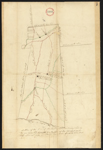
Two plans of Amherst, surveyor's name not given, dated 1794-5.
13357.
Two plans of Amherst, surveyor's name not given, dated 1794-5.
13358.
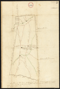
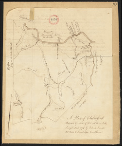
Two plans of Chelmsford made by Fred French, dated November, 1794.
13359.
Two plans of Chelmsford made by Fred French, dated November, 1794.
13360.
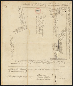
Two plans of Hawley, surveyor's name not given, dated May, 1795.
‹ Prev
Next ›
1
2
…
664
665
666
667
668
669
670
671
672
…
708
709