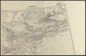
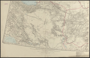
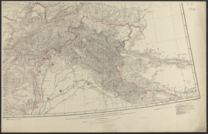
Turkestan and the countries between the British and the Russian dominions in Asia : mapped on the basis of the surveys made by British and Russian officers up to 1875


Item Information
- Title:
- Turkestan and the countries between the British and the Russian dominions in Asia : mapped on the basis of the surveys made by British and Russian officers up to 1875
- Cartographer:
- Survey of India. Trigonometrical Branch
- Cartographer:
- Atkinson, G. W. E.
- Contributor:
- Dyson, C.
- Contributor:
- Litchfield, E. F.
- Contributor:
- Ollenbach, C. G.
- Contributor:
- Peyton, J.
- Publisher:
- United States. Army. Office of the Chief of Engineers
- Name on Item:
-
compiled by G.W.E. Atkinson ; hill shading by J. Peyton and E.F. Litchfield ; C. Dyson, photo. ; C.G. Ollenbach, zinco.
- Date:
-
1885
- Format:
-
Maps/Atlases
- Location:
-
Boston Public Library
Norman B. Leventhal Map & Education Center - Collection (local):
-
Norman B. Leventhal Map & Education Center Collection
- Subjects:
-
Asia, Central--Maps
Afghanistan--Maps
- Places:
-
Central Asia (area)
Afghanistan
- Extent:
- 1 map on 4 sheets : col. ; 113 x 194 cm, on sheets 62 x 96 cm
- Terms of Use:
-
No known copyright restrictions.
No known restrictions on use.
- Publisher:
-
[Washington, D.C.] :
Republished in the Office of the Chief of Engineers, U.S. Army
- Edition:
- 3rd edition
- Scale:
-
Scale 1:2,027,520. 1 inch = 32 miles
- Language:
-
English
- Notes:
-
Relief shown by hachures and spot heights.
- Identifier:
-
06_01_015330C
06_01_015330A
06_01_015330B
06_01_015330D
- Call #:
-
G7405 1885 .S87
- Barcode:
-
39999085935359


