Toggle navigation
LMEC Home
Exhibitions
Georeferencing
Tools for Teachers
Collections
My Favorites
Sign Up / Log In
Search
Search the map portal
Map Collection
Map Collection
Map Sets
Search
Search
Search for
Search In
All Fields
Creator
Title
Subject
Place
Search All Digital Collections
Advanced Search
248 Results
My Search
Start Over
Date
1845
to
1849
Remove constraint Date: <span class='from'>1845</span> to <span class='to'>1849</span>
Filter your Search
Place
North and Central America
137
United States
114
Massachusetts
53
Europe
43
Oceania
32
Suffolk (county)
22
Boston
20
New England
16
more
Place
»
Topic
United States Exploring Expedition (1838-1842)
16
New England--Maps
12
Boston (Mass.)--Maps
10
Massachusetts--Maps
10
Railroads--New England--Maps
10
United States--Maps
10
Railroads--Massachusetts--Maps
8
Railroads--New York (State)--Maps
7
more
Topic
»
Date
1845
to
1849
[remove]
248
Date range begin
–
Date range end
Current results range from
1770
to
1990
1845
to
1845
111
1846
to
1846
119
1847
to
1847
114
1848
to
1848
116
1849
to
1849
138
Creator
United States Exploring Expedition (1838-1842)
34
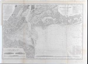
Wilkes, Charles, 1798-1877
31
Sherman & Smith
19
J. & C. Walker (Firm)
10
Great Britain. Hydrographic Office
7
Vidal, A. T. E. (Alexander Thomas Emeric), 1792-1863
7
Horsburgh, James
5
Wadsworth, Alexander, 1806-1898
5
more
Creator
»
Format
Maps/Atlases
244
Manuscripts
14
Prints
3
Books
1
Georeferenced
Yes
32
No
216
Collection
Norman B. Leventhal Map & Education Center Collection
221
Boston and New England Maps
62
Maritime Charts and Atlases
52
Urban Maps
50
American Revolutionary War-Era Maps
13
Library of Congress Collection
5
Robert E. Diefenbach Map Collection at Phillips Academy
5
Lucius Beebe Memorial Library Historic Maps
4
more
Collection
»
Available to use
No known restrictions
227
Creative Commons license
11
Search Constraints
Sort by relevance
relevance
title
date (asc)
date (desc)
Number of results to display per page
20 per page
10
per page
20
per page
50
per page
100
per page
View results as:
grid view
map view
Search Results
101.
Map of Liberia
102.
Map of Malta and its dependencies
103.
Map of Massachusetts, Connecticut and Rhode Island constructed from the latest authorities
104.
A Map of Methuen, Mass
105.
Map of Mobile Bay
106.
Map of New England
107.
Map of New England exhibiting the rail road & telegraphic lines now in operation
108.
A map of New-England : being the first that ever was here cut, and done by the best pattern that could be had, which being in...
109.
Map of New-York Bay and Harbor and the environs : [with colored manuscript additions to show positions of troops and fleets at...
110.
Map of New-York Bay and Harbor and the environs : Founded upon a trigonometrical survey under the direction of F.R. Hassler,...
111.
Map of North America
112.
Map of Oregon and upper California, from the surveys of John Charles Frémont and other authorities
113.
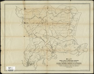
Map of parts of Essex & part of Middlesex counties, showing the rail road routes between Salem, Lowell, Boston & Lawrence
114.
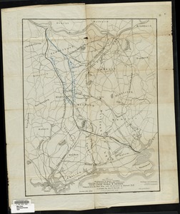
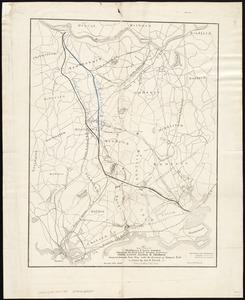
Map of parts of Middlesex & Essex counties showing the rail road routes between Salem, Lowell, Boston & Methuen
115.
Map of parts of Middlesex & Essex counties, showing the rail road routes between Salem, Lowell, Boston & Methuen
116.
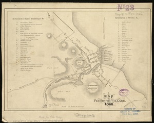
A map of Plymouth Village : 1846
117.
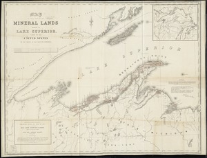
Map of that part of the mineral lands adjacent to Lake Superior, ceded to the United States by the treaty of 1842 with the...
118.
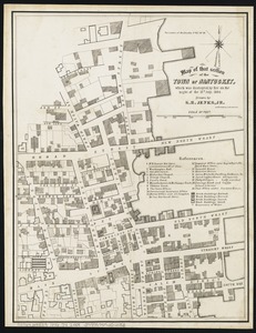
Map of that section of the town of Nantucket, which was destroyed by the fire on the night of the 13th July, 1846
119.
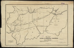
Map of the Alton & Springfield railroad, in Illinois : showing its connection with other roads and proposed roads leading to...
120.
Map of the Boston & Maine Railroad, showing its relative position & connection with other railroads
‹ Prev
Next ›
1
2
3
4
5
6
7
8
9
10
…
12
13