Toggle navigation
LMEC Home
Exhibitions
Georeferencing
Tools for Teachers
Collections
My Favorites
Sign Up / Log In
Search
Search the map portal
Map Collection
Map Collection
Map Sets
Search
Search
Search for
Search In
All Fields
Creator
Title
Subject
Place
Search All Digital Collections
Advanced Search
14164 Results
Filter your Search
Place
North and Central America
10,832
United States
8,868
Massachusetts
2,832
Suffolk (county)
1,688
Boston
1,644
Europe
1,428
Canada
1,010
New York
684
more
Place
»
Topic
Boston (Mass.)--Maps
753
City planning--Massachusetts--Boston--Maps
419
United States--History--Revolution, 1775-1783--Maps
331
United States--Maps
331
Real property--Massachusetts--Boston--Maps
254
Urban renewal--Massachusetts--Boston--Maps
254
North America--Maps--Early works to 1800
241
Massachusetts--Maps
236
more
Topic
»
Date
Date range begin
–
Date range end
Current results range from
1482
to
2023
View distribution
Creator
United States. Hydrographic Office
597
Boston Redevelopment Authority
404
Des Barres, Joseph F. W. (Joseph Frederick Wallet), 1722-1824
247
Jefferys, Thomas, -1771
172
United States. National Ocean Service
170
Royal United Services Institute for Defence and Security Studies
160
George, III, King of Great Britain, 1738-1820
152
George, IV, King of Great Britain, 1762-1830
151
more
Creator
»
Format
Maps/Atlases
13,978
Manuscripts
985
Prints
102
Books
53
Drawings/Illustrations
44
Photographs
15
Objects/Artifacts
13
Documents
7
more
Format
»
Georeferenced
Yes
979
No
13,185
Collection
Norman B. Leventhal Map & Education Center Collection
9,162
American Revolutionary War-Era Maps
3,629
Boston and New England Maps
2,936
Urban Maps
2,511
Maritime Charts and Atlases
1,169
William L. Clements Library Collection
910
Library of Congress Collection
618
Boston Redevelopment Authority Collection
475
more
Collection
»
Available to use
No known restrictions
10,408
Creative Commons license
1,678
Search Constraints
Sort by relevance
relevance
title
date (asc)
date (desc)
Number of results to display per page
20 per page
10
per page
20
per page
50
per page
100
per page
View results as:
grid view
map view
Search Results
10241.
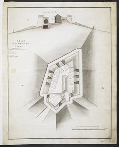
PLAN of the Bastion at Fort George
10242.
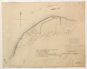
Plan of the Battery on the South Shore Erected against Fort Levy on the 21. of August 1760
10243.
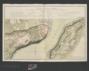
Plan of the battle and situation of the British and French armys on the Heights of Abraham the 28th: of April 1760 : repetition...
10244.
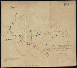
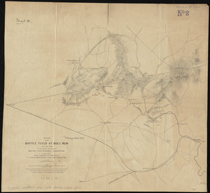
Plan of the battle field at Bull Run, July 21st 1861 : to accompany the report of Brigr. Genl. Irvin McDowell, commanding ; map 1
10245.
Plan of the battle field at Bull Run, July 21st 1861 : to accompany the report of Brigr. Genl. Irvin McDowell, commanding ; map 2
10246.
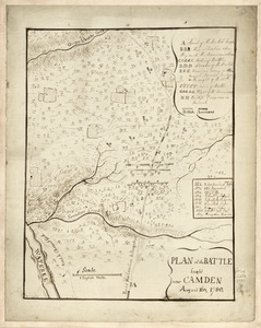
Plan of the battle fought near Camden August 16th 1780
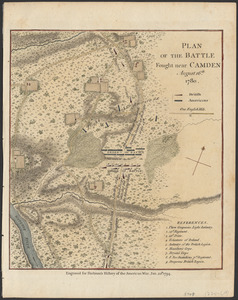
10247.
Plan of the battle fought near Camden, August 16th, 1780
10248.
Plan of the battle fought near Camden August 16th, 1780
10249.
Plan of the battle fought on the 28th of April 1760 upon the height of Abraham near Quebec, between the British troops...
10250.
Plan of the Battle fought on the Plains of Abraham, September the 13th 1759
10251.
Plan of the battle fought the 28th of April 1760 upon the Height of Abraham near Quebec between the British troops garrisoned...
10252.
Plan of the battle near Bushy Run, gained by Colonel Bouquet over the Delawares, Shawanese, Mingoes, Wyandots, Mohikons,...
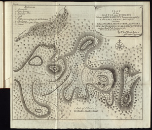
10253.
Plan of the battle near Bushy-Run gained by His Majesty's troops commanded by Colonel Henry Bouquet over the Delawares,...
10254.
A Plan of the Battle of Bunker Hill
10255.
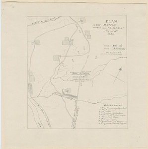
Plan of the Battle of Gum Swamp alias Sutton Wood, on the 16th August 1780 between the royal army, 1600, commanded by Lieut:...
10256.
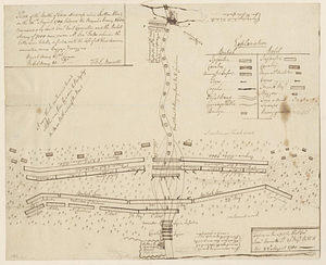
Plan of the battle of Monmouth, 28th of June, 78
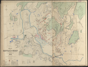
10257.
Plan of the battle of Sedan fought 1st September 1870
10258.
Plan of the battle, on Bunker's Hill : fought on the 17th of June 1775
10259.
Plan of the battle, on Bunker's Hill : fought on the 17th of June 1775
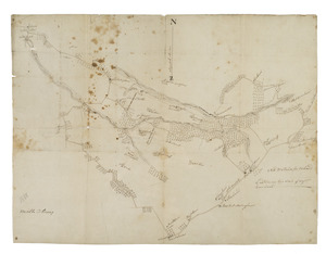
10260.
[Plan of the battles of Saratoga]
‹ Prev
Next ›
1
2
…
509
510
511
512
513
514
515
516
517
…
708
709


![[Plan of the battles of Saratoga]](https://bpldcassets.blob.core.windows.net/derivatives/images/commonwealth:z603vw07d/image_thumbnail_300.jpg)