Toggle navigation
LMEC Home
Exhibitions
Georeferencing
Tools for Teachers
Collections
My Favorites
Sign Up / Log In
Search
Search the map portal
Map Collection
Map Collection
Map Sets
Search
Search
Search for
Search In
All Fields
Creator
Title
Subject
Place
Search All Digital Collections
Advanced Search
387 Results
My Search
Start Over
Date
1900
to
1904
Remove constraint Date: <span class='from'>1900</span> to <span class='to'>1904</span>
Filter your Search
Place
North and Central America
303
United States
247
Massachusetts
100
Boston
60
Suffolk (county)
60
Asia
36
Canada
26
New York
18
more
Place
»
Topic
Boston (Mass.)--Maps
41
Landowners--Massachusetts--Boston--Maps
26
Gold mines and mining--Nova Scotia--Maps
13
United States--Maps
10
Indian reservations--Oklahoma--Maps
9
Massachusetts--Maps
9
Geology--Nova Scotia--Halifax (County)--Maps
8
Halifax (N.S. : County)--Maps
8
more
Topic
»
Date
1900
to
1904
[remove]
387
Date range begin
–
Date range end
Current results range from
1770
to
1999
1900
to
1900
114
1901
to
1901
95
1902
to
1902
78
1903
to
1903
154
1904
to
1904
89
Creator
United States. Post Office Dept
34
Lamb, George
16
United States. War Department
16
Geological Survey of Canada
14
Geo. H. Walker & Co.
13
Geo. H. Walker & Co
11
Bromley, George Washington
10
Bromley, Walter Scott
10
more
Creator
»
Format
Maps/Atlases
382
Manuscripts
4
Prints
3
Books
2
Documents
1
Photographs
1
Posters
1
Georeferenced
Yes
53
No
334
Collection
Norman B. Leventhal Map & Education Center Collection
363
Urban Maps
39
Boston and New England Maps
37
Massachusetts Real Estate Atlases
9
Robert E. Diefenbach Map Collection at Phillips Academy
9
Maritime Charts and Atlases
3
Ralph Finos Map Collection at Phillips Academy
2
American Revolutionary War-Era Maps
1
more
Collection
»
Available to use
No known restrictions
374
Creative Commons license
1
Search Constraints
Sort by relevance
relevance
title
date (asc)
date (desc)
Number of results to display per page
20 per page
10
per page
20
per page
50
per page
100
per page
View results as:
grid view
map view
Search Results
81.
Guide map of Boston
82.
Hawaiian or Sandwich Islands
83.
Highway map of Plymouth County, Massachusetts : prepared for the Plymouth County atlas
84.
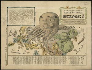
A humorous diplomatic atlas of Europe and Asia
85.
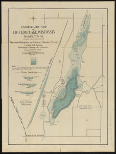
Hydrographic map of Big Cedar Lake, Wisconsin, Washington Co.
86.
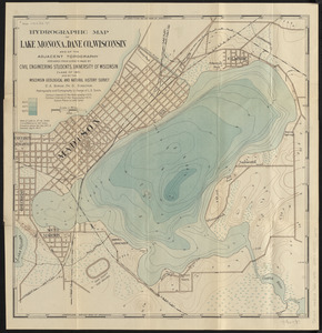
Hydrographic map of Lake Monona, Dane Co., Wisconsin and of the adjacent topography
87.
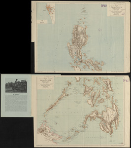
Index map, city of Manila
88.
Indexed map of Boston
89.
Indian Territory : progress of sub-division survey, June 30, 1902
90.
Indian Territory
91.
Indian Territory showing railroad systems - June 30, 1902
92.
Indian Territory showing townsites approved to June 30-1902
93.
Indo-Chine, carte de la mission Pavie
94.
Ireland
95.
Japan
96.
Karte der Philippinen : in zwei sectionen : nördliches und südliches blatt
97.
Karte des nordwestlichen Kleinasien : nach eigenen aufnahmen und unveröffentlichtem material auf Heinrich Kiepert's grundlage
98.
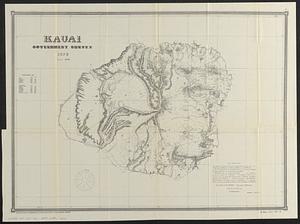
Kauai, government survey, 1878
99.
[Lake Pleasant, Massachusetts]
100.
Lake Winnipesaukee, New Hampshire
‹ Prev
Next ›
1
2
3
4
5
6
7
8
9
…
19
20


![[Lake Pleasant, Massachusetts]](https://bpldcassets.blob.core.windows.net/derivatives/images/commonwealth:9s161g546/image_thumbnail_300.jpg)
