Toggle navigation
LMEC Home
Exhibitions
Georeferencing
Tools for Teachers
Collections
My Favorites
Sign Up / Log In
Search
Search the map portal
Map Collection
Map Collection
Map Sets
Search
Search
Search for
Search In
All Fields
Creator
Title
Subject
Place
Search All Digital Collections
Advanced Search
152 Results
My Search
Start Over
1886
Remove constraint 1886
Filter your Search
Place
North and Central America
120
United States
96
Massachusetts
45
Middlesex (county)
19
Asia
16
Suffolk (county)
14
Boston
12
Worcester (county)
11
more
Place
»
Topic
Zoning
9
Boston (Mass.)--Maps
8
China--Historical geography--Maps
6
Brookline (Mass.)--Maps
3
Massachusetts--Maps
3
Atlantic Coast (N.S.)--Maps
2
Atlantic Coast (New England)--Maps
2
Boston (Mass.)--Aerial views
2
more
Topic
»
Date
Date range begin
–
Date range end
Current results range from
1831
to
1994
View distribution
Creator
United States. Hydrographic Office
37
Burleigh, L. R., 1853-1923
22
Herrmann, Albert, 1886-1945
11
Comey, Arthur C. (Arthur Coleman), 1886-1954
10
Franke, M. (Max)
7
Waddey, J. A. (John A.)
6
Birch, C. E. (Charles E.)
5
Ruebsam, E. A. (E. August)
5
more
Creator
»
Format
Maps/Atlases
152
Georeferenced
Yes
10
No
142
Collection
Norman B. Leventhal Map & Education Center Collection
136
Urban Maps
68
Boston and New England Maps
60
Maritime Charts and Atlases
43
Lucius Beebe Memorial Library Historic Maps
10
Massachusetts Real Estate Atlases
5
Town plans, 1830
1
Available to use
No known restrictions
136
Search Constraints
Sort by relevance
relevance
title
date (asc)
date (desc)
Number of results to display per page
20 per page
10
per page
20
per page
50
per page
100
per page
View results as:
grid view
map view
Search Results
81.
New Boston and Charles River Bay
82.
The embankment and park on Charles River Bay
83.
South Pacific Ocean, Easter Island (Te Pito te Henua Island)
84.
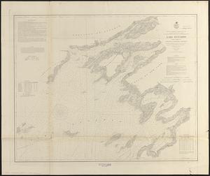
Lake Ontario
85.
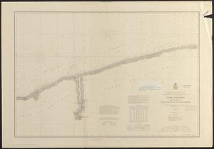
Lake Ontario
86.
Chart of Isle Royale including north west coast of Lake Superior
87.
South end of Lake Huron and head of the St. Clair River
88.
Coast chart no. 186 : Choctawhatchee Inlet to Pensacola Entrance, West Florida : report of Navy Yard Site Commission, Gulf of...
89.
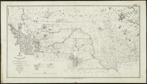
Map of the Department of Dakota including Minnesota, Dakota and Montana
90.
New bond paper map of the city of Washington
91.
Preliminary map of south east Kentucky
92.
Rand, McNally & Co.'s California
93.
State of Arkansas
94.
State of Indiana
95.
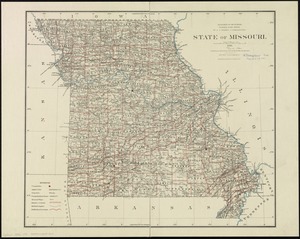
State of Missouri
96.
State of Wisconsin
97.
Territory of New Mexico
98.
Agricultural map of the Jackson Purchase
99.
Amherst, Mass
100.
Atlas of Gardner town, Massachusetts
‹ Prev
Next ›
1
2
3
4
5
6
7
8