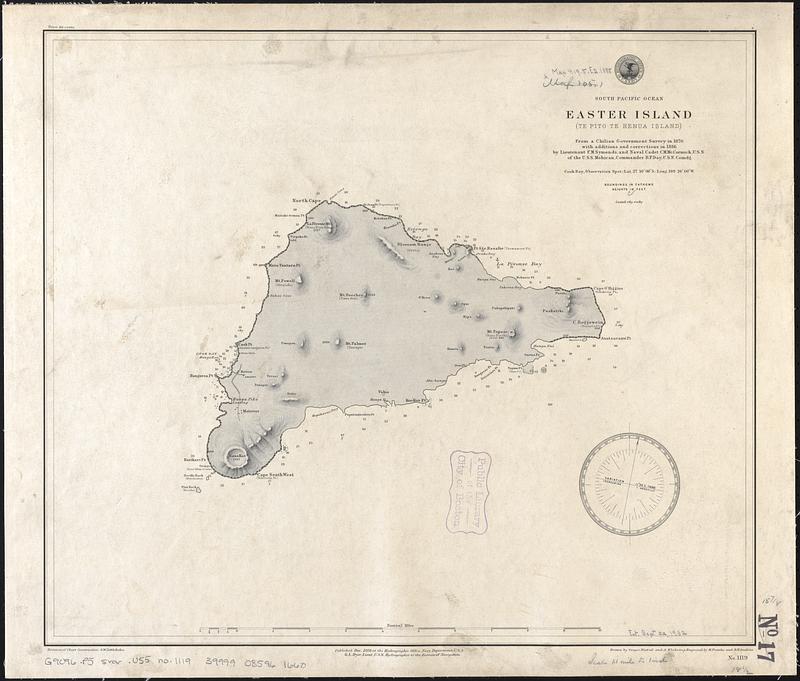
South Pacific Ocean, Easter Island (Te Pito te Henua Island)
Item Information
- Title:
- South Pacific Ocean, Easter Island (Te Pito te Henua Island)
- Title (alt.):
-
Easter Island (Te Pito te Henua Island)
- Issuing body:
- United States. Hydrographic Office
- Surveyor:
- Symonds, Frederick M.
- Surveyor:
- McCormick, Charles M.
- Draftsman:
- Noetzel, G. (Gregor)
- Draftsman:
- Klakring, A. (Alfred)
- Engraver:
- Franke, M. (Max)
- Engraver:
- Gaskins, R. H. (Richard H.)
- Name on Item:
-
from a Chilean government survey in 1870, with additions and corrections in 1886 by Lieutenant F.M. Symonds, and Naval Cadet C.M. McCormick, U.S.N. of the U.S.S. Mohican, Commander B.F. Day, U.S.N. comdg. ; drawn by Gregor Noetzel and A. Klakring ; engraved by M. Franke and R.H. Gaskins
- Date:
-
1888
- Format:
-
Maps/Atlases
- Genre:
-
Nautical charts
- Location:
-
Boston Public Library
Norman B. Leventhal Map & Education Center - Collection (local):
-
Norman B. Leventhal Map & Education Center Collection
- Subjects:
-
Easter Island--Maps
Nautical charts--Easter Island
- Places:
-
ChileValparaíso (region)Easter Island (island)
- Extent:
- 1 map ; 41 x 47 cm
- Terms of Use:
-
No known copyright restrictions.
No known restrictions on use.
- Publisher:
-
Washington, D.C. :
Hydrographic Office
- Scale:
-
Scale approximately 1:75,000
- Language:
-
English
- Notes:
-
Relief shown by shading and spot heights. Depths shown by soundings.
- Identifier:
-
06_01_017603
- Call #:
-
G9096.P5 svar .U55 no. 1119
- Barcode:
-
39999085961660


