Toggle navigation
LMEC Home
Exhibitions
Georeferencing
Tools for Teachers
Collections
My Favorites
Sign Up / Log In
Search
Search the map portal
Map Collection
Map Collection
Map Sets
Search
Search
Search for
Search In
All Fields
Creator
Title
Subject
Place
Search All Digital Collections
Advanced Search
13680 Results
My Search
Start Over
Date facet yearly ssim
2000
to
2019
Remove constraint Date facet yearly ssim: <span class='from'>2000</span> to <span class='to'>2019</span>
Filter your Search
Place
North and Central America
10,344
United States
8,475
Massachusetts
2,789
Suffolk (county)
1,677
Boston
1,633
Europe
1,415
Canada
950
New York
649
more
Place
»
Topic
Boston (Mass.)--Maps
747
City planning--Massachusetts--Boston--Maps
418
United States--History--Revolution, 1775-1783--Maps
329
United States--Maps
322
Real property--Massachusetts--Boston--Maps
254
Urban renewal--Massachusetts--Boston--Maps
254
Massachusetts--Maps
231
Insurance surveys
197
more
Topic
»
Date
Date range begin
–
Date range end
Current results range from
1482
to
2023
View distribution
Creator
United States. Hydrographic Office
597
Boston Redevelopment Authority
404
Des Barres, Joseph F. W. (Joseph Frederick Wallet), 1722-1824
247
Royal United Services Institute for Defence and Security Studies
160
Jefferys, Thomas, -1771
154
George, III, King of Great Britain, 1738-1820
152
George, IV, King of Great Britain, 1762-1830
151
O.H. Bailey & Co
148
more
Creator
»
Format
Maps/Atlases
13,499
Manuscripts
985
Prints
102
Books
49
Drawings/Illustrations
44
Photographs
15
Objects/Artifacts
13
Documents
7
more
Format
»
Georeferenced
Yes
979
No
12,701
Collection
Norman B. Leventhal Map & Education Center Collection
9,096
American Revolutionary War-Era Maps
3,305
Boston and New England Maps
2,915
Urban Maps
2,471
Maritime Charts and Atlases
1,169
William L. Clements Library Collection
910
Library of Congress Collection
618
Boston Redevelopment Authority Collection
475
more
Collection
»
Available to use
No known restrictions
10,246
Creative Commons license
1,678
Search Constraints
Sort by relevance
relevance
title
date (asc)
date (desc)
Number of results to display per page
20 per page
10
per page
20
per page
50
per page
100
per page
View results as:
grid view
map view
Search Results
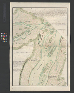
8061.
Parish of Varrenes. Parish of Pointe aux Trembles. Parish of La Chenais
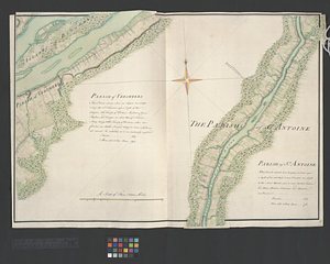
8062.
Parish of Vercheres. Parish of St. Antoine
8063.
Park Plaza : illustrative site plan
8064.
Park Plaza : illustrative site plan showing alternate apartment building configuration
8065.
Park Plaza building study stage environmental impact analysis : environmental base : sanitary sewerage and storm drainage
8066.
Park Plaza traffic improvements & grade level controls
8067.
Park Plaza urban renewal area : environmental deficiencies and blighting influences map
8068.
Park Plaza urban renewal area : map no. 4 building deficiencies map
8069.
Park Plaza urban renewal area : map no. 5 ownership data map
8070.
Park Plaza urban renewal area : map no. 2 land use map (existing)
8071.
Park Plaza urban renewal area : map no. 1 boundary map
8072.
Park Plaza urban renewal area : map no. 6 land disposal map
8073.
Park Plaza urban renewal area : map no. 3 land acquisition map
8074.
Park Plaza urban renewal area : environmental deficiencies and blighting influences map
8075.
Park Plaza urban renewal area : 1973 survey building deficiencies map for Park Plaza stage I
8076.
Park Plaza urban renewal area : building conditions map
8077.
Parker Hill-Fenway project no. Mass. R-48 : police signal system, fire alarm system and M.T.A. facilities
8078.
Parker Hill-Fenway project no. Mass. R-48 : sewer and storm drain system
8079.
Parker Hill-Fenway project no. Mass. R-48 : water distribution system
8080.
Parker Hill-Fenway urban renewal area r-48 : building conditions
‹ Prev
Next ›
1
2
…
400
401
402
403
404
405
406
407
408
…
683
684