Toggle navigation
LMEC Home
Exhibitions
Georeferencing
Tools for Teachers
Collections
My Favorites
Sign Up / Log In
Search
Search the map portal
Map Collection
Map Collection
Map Sets
Search
Search
Search for
Search In
All Fields
Creator
Title
Subject
Place
Search All Digital Collections
Advanced Search
13385 Results
Filter your Search
Place
North and Central America
9,353
United States
7,078
Suffolk (county)
1,664
Boston
1,621
Europe
1,035
Canada
949
Massachusetts
794
New York
532
more
Place
»
Topic
Boston (Mass.)--Maps
741
City planning--Massachusetts--Boston--Maps
418
United States--History--Revolution, 1775-1783--Maps
329
United States--Maps
315
Urban renewal--Massachusetts--Boston--Maps
254
Real property--Massachusetts--Boston--Maps
252
Massachusetts--Maps
219
Insurance surveys
197
more
Topic
»
Date
Date range begin
–
Date range end
Current results range from
1482
to
2023
View distribution
Creator
United States. Hydrographic Office
595
Boston Redevelopment Authority
403
Des Barres, Joseph F. W. (Joseph Frederick Wallet), 1722-1824
247
Royal United Services Institute for Defence and Security Studies
160
Jefferys, Thomas, -1771
154
George, III, King of Great Britain, 1738-1820
152
George, IV, King of Great Britain, 1762-1830
151
O.H. Bailey & Co
148
more
Creator
»
Format
Maps/Atlases
13,205
Manuscripts
985
Prints
102
Books
49
Drawings/Illustrations
44
Photographs
15
Objects/Artifacts
13
Documents
7
more
Format
»
Georeferenced
Yes
979
No
12,406
Collection
Norman B. Leventhal Map Center Collection
8,891
American Revolutionary War-Era Maps
3,305
Boston and New England Maps
2,804
Urban Maps
2,397
Maritime Charts and Atlases
1,150
William L. Clements Library Collection
910
Library of Congress Collection
618
Boston Redevelopment Authority Collection
475
more
Collection
»
Available to use
No known restrictions
9,952
Creative Commons license
1,677
Search Constraints
Sort by relevance
relevance
title
date (asc)
date (desc)
Number of results to display per page
20 per page
10
per page
20
per page
50
per page
100
per page
View results as:
grid view
map view
Search Results
8041.
Paulus Hook and Bergen : surveyed and draughted from the 22d. to 29th June 1781
8042.
Pawtuxet, Rhode Island : 1890
8043.
La Paz : South America 1:1,000,000
8044.
Peace map of the world united : a pictorial history of transportation and communications from Jonah to the jet plane as paths...
8045.
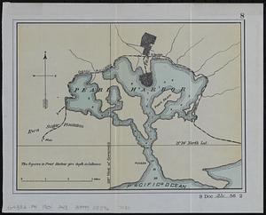
Pearl Harbor
8046.
Pedemontium et reliquae ditiones Italiae regiae celsitudini Sabaudicae subditae : cum regionibus adjacentibus
8047.
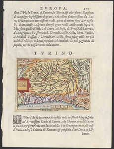
Pedemontivm
8048.
Peking
8049.
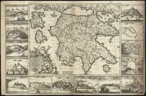
Peloponnesus hodie Moreae Regnum : distincté divisum in omnes suas provincias, hodiernas atque veteres, cui et adiuguntur...
8050.
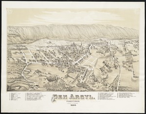
Pen Argyl : Pennsylvania
8051.
Penacook, N.H
8052.
Pend Oreille National Forest, Idaho
8053.
The peninsula and Gulf of Florida, or New Bahama Channel, : with the Bahama Island
8054.
Pennsylvania
8055.
Pennsylvania
8056.
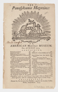
The Pennsylvania Magazine: or, American Monthly Museum : for August 1775 : [table of contents]
8057.
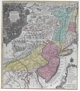
Pennsylvania, Nova Jersey, et Nova York cum regionibus ad Fluvium Delaware in America sitis
8058.
Penobscot Bay
8059.
Penobscot River and Bay, with the operations of the English fleet, under Sir George Collyer : against the division of...
8060.
Pensacola
‹ Prev
Next ›
1
2
…
399
400
401
402
403
404
405
406
407
…
669
670