Toggle navigation
LMEC Home
Exhibitions
Georeferencing
Tools for Teachers
Collections
My Favorites
Sign Up / Log In
Search
Search the map portal
Map Collection
Map Collection
Map Sets
Search
Search
Search for
Search In
All Fields
Creator
Title
Subject
Place
Search All Digital Collections
Advanced Search
13680 Results
My Search
Start Over
Date facet yearly ssim
2000
to
2019
Remove constraint Date facet yearly ssim: <span class='from'>2000</span> to <span class='to'>2019</span>
Filter your Search
Place
North and Central America
10,344
United States
8,475
Massachusetts
2,789
Suffolk (county)
1,677
Boston
1,633
Europe
1,415
Canada
950
New York
649
more
Place
»
Topic
Boston (Mass.)--Maps
747
City planning--Massachusetts--Boston--Maps
418
United States--History--Revolution, 1775-1783--Maps
329
United States--Maps
322
Real property--Massachusetts--Boston--Maps
254
Urban renewal--Massachusetts--Boston--Maps
254
Massachusetts--Maps
231
Insurance surveys
197
more
Topic
»
Date
Date range begin
–
Date range end
Current results range from
1482
to
2023
View distribution
Creator
United States. Hydrographic Office
597
Boston Redevelopment Authority
404
Des Barres, Joseph F. W. (Joseph Frederick Wallet), 1722-1824
247
Royal United Services Institute for Defence and Security Studies
160
Jefferys, Thomas, -1771
154
George, III, King of Great Britain, 1738-1820
152
George, IV, King of Great Britain, 1762-1830
151
O.H. Bailey & Co
148
more
Creator
»
Format
Maps/Atlases
13,499
Manuscripts
985
Prints
102
Books
49
Drawings/Illustrations
44
Photographs
15
Objects/Artifacts
13
Documents
7
more
Format
»
Georeferenced
Yes
979
No
12,701
Collection
Norman B. Leventhal Map & Education Center Collection
9,096
American Revolutionary War-Era Maps
3,305
Boston and New England Maps
2,915
Urban Maps
2,471
Maritime Charts and Atlases
1,169
William L. Clements Library Collection
910
Library of Congress Collection
618
Boston Redevelopment Authority Collection
475
more
Collection
»
Available to use
No known restrictions
10,246
Creative Commons license
1,678
Search Constraints
Sort by relevance
relevance
title
date (asc)
date (desc)
Number of results to display per page
20 per page
10
per page
20
per page
50
per page
100
per page
View results as:
grid view
map view
Search Results
8001.
Panoramic view of Boston showing golden semicircle
8002.
[Panoramic view of Newport, Rhode Island and the harbor showing the position of the French fleet and troop encampments]
8003.
Panoramic view of the city of Calais, St. Stephen and Milltown : Washington Co. Maine, Charlotte Co. New Brunswick : mills,...
8004.
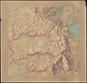
Panoramic view of the Crater Lake National Park, Oregon
8005.
[Panoramic view of the Gettysburg battlefield]
8006.
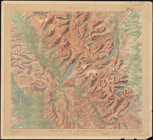
Panoramic view of the Glacier National Park, Montana
8007.
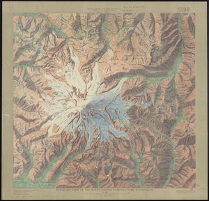
Panoramic view of the Mount Rainier National Park, Washington
8008.
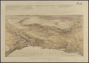
Panoramic view of the seat of war in Europe
8009.
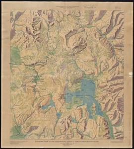
Panoramic view of the Yellowstone National Park, Wyoming-Montana-Idaho
8010.
Panoramic view of the Yosemite National Park, California
8011.
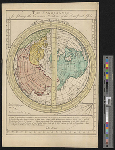
The panorganon for solving the common problems of the terrestrial globe : Northern Hemisphere
8012.
Pansacola o Santta María de Galbe, puerto y presidio del Ry. de España situado en la costa del nortte del Seno Mexicano, los...
8013.
Paraguay, ó, prov. de Rio de la Plata cum regionibus adiacentibus Tucuman et Sta. Cruz de la Sierra
8014.
Paraguay, ó prov. de Rio de la Plata cum regionibus adiacentibus Tucuman et Sta. Cruz de la Sierra
8015.
Paraguay, ó prov. de Rio de la Plata cum regionibus adiacentibus Tucuman et Sta. Cruz de la Sierra
8016.
Le Paraguayr, Le Chili, La Terre, et les Isles Magellanicques : tirées de diverses rélations
8017.
Paraquaria vulgo Paraguay : cum adjacentibus
8018.
Parcel 10 : Sears Crescent, Government Center
8019.
Parcel 13 rehabilitation
8020.
Parcel 22
‹ Prev
Next ›
1
2
…
397
398
399
400
401
402
403
404
405
…
683
684

![[Panoramic view of Newport, Rhode Island and the harbor showing the position of the French fleet and troop encampments]](https://bpldcassets.blob.core.windows.net/derivatives/images/commonwealth:dz010v493/image_thumbnail_300.jpg)
![[Panoramic view of the Gettysburg battlefield]](https://bpldcassets.blob.core.windows.net/derivatives/images/commonwealth:xg94j2023/image_thumbnail_300.jpg)