Toggle navigation
LMEC Home
Exhibitions
Georeferencing
Tools for Teachers
Collections
My Favorites
Sign Up / Log In
Search
Search the map portal
Map Collection
Map Collection
Map Sets
Search
Search
Search for
Search In
All Fields
Creator
Title
Subject
Place
Search All Digital Collections
Advanced Search
2261 Results
My Search
Start Over
london
Remove constraint london
Filter your Search
Place
North and Central America
1,479
United States
921
Europe
363
Canada
347
North America
194
New York
128
Massachusetts
111
New England
104
more
Place
»
Topic
North America--Maps--Early works to 1800
137
Coasts--Nova Scotia--Maps
64
New England--Maps--Early works to 1800
57
United States--History--French and Indian War, 1754-1763--Maps
57
United States--History--French and Indian War, 1754-1763--Maps, Manuscript--Early works to 1800
56
United States--Maps--Early works to 1800
54
United States--History--Revolution, 1775-1783--Maps
40
Nova Scotia--Maps--Early works to 1800
39
more
Topic
»
Date
Date range begin
–
Date range end
Current results range from
1624
to
1999
View distribution
Creator
Des Barres, Joseph F. W. (Joseph Frederick Wallet), 1722-1824
242
Jefferys, Thomas, -1771
167
George, III, King of Great Britain, 1738-1820
149
George, IV, King of Great Britain, 1762-1830
148
Sayer, Robert, 1725-1794
115
Faden, William, 1749-1836
109
Moll, Herman, d. 1732
72
Robert Sayer and John Bennett (Firm)
57
more
Creator
»
Format
Maps/Atlases
2,219
Manuscripts
161
Prints
23
Drawings/Illustrations
15
Books
4
Objects/Artifacts
1
Georeferenced
Yes
137
No
2,124
Collection
American Revolutionary War-Era Maps
1,355
Norman B. Leventhal Map & Education Center Collection
1,305
Maritime Charts and Atlases
263
British Library Collection
163
William L. Clements Library Collection
160
Boston and New England Maps
152
Richard H. Brown Revolutionary War Map Collection at Mount Vernon
146
MacLean Collection Map Library
140
more
Collection
»
Available to use
No known restrictions
1,271
Creative Commons license
569
Search Constraints
Sort by relevance
relevance
title
date (asc)
date (desc)
Number of results to display per page
20 per page
10
per page
20
per page
50
per page
100
per page
View results as:
grid view
map view
Search Results
581.
Index diagram of sheets for the International map on the scale of 1:1,000,000
582.
International map of the world on the scale 1:1,000,000
583.
International map of the world on the scale 1:1,000,000
584.
Annapolis Royal ... : St. Mary's Bay
585.
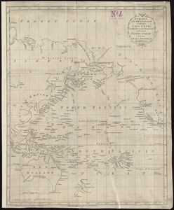
A chart of the discoveries made by the late Capt. Cook, & other European navigators, in the great Pacific Ocean between Asia...
586.
Coast of Maine from Moose Cove to Gouldsboro Bay
587.
The isthmus of Nova Scotia
588.
A Map of the British and French settlements in North America : (part the second) containing part of New York, Pensilvania, New...
589.
A map of the middle British colonies in North America : first published by Mr. Lewis Evans, of Philadelphia, in 1755; and since...
590.
A new and accurat map of the world
591.
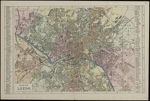
Plan of Leeds : divided into 1/4 mile squares & circles
592.
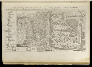
A prospective view of the battle fought near Lake George, on the 8th of Sepr. 1755, between 2000 English, with 250 Mohawks,...
593.
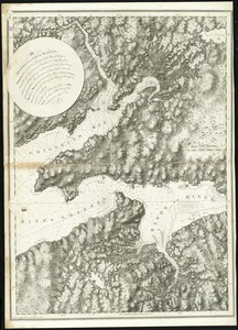
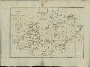
Sketch of the western countries of Canada
594.
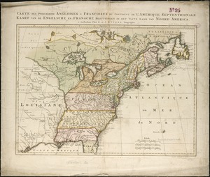
Carte des possessions angloises & françoises du continent de l'Amérique septentrionale = Kaart van de Engelsche en Fransche...
595.
A correct map of Connecticut from actual survey
596.
A new general chart of the West Indies from the latest marine journals and surveys regulated and ascertained by astronomical...
597.
North Carolina form the best authorities. 1800
598.
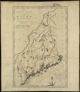
The province of Maine, from the best authorities
599.
A map of the North Pole with all the territories that lye near it, known to us &c. According to the latest discoveries, and...
600.
St. Vincent, from an actual survey made in the year 1773 : after the treaty with the Caribs
‹ Prev
Next ›
1
2
…
26
27
28
29
30
31
32
33
34
…
113
114