Toggle navigation
LMEC Home
Exhibitions
Georeferencing
Tools for Teachers
Collections
My Favorites
Sign Up / Log In
Search
Search the map portal
Map Collection
Map Collection
Map Sets
Search
Search
Search for
Search In
All Fields
Creator
Title
Subject
Place
Search All Digital Collections
Advanced Search
248 Results
My Search
Start Over
Date
1845
to
1849
Remove constraint Date: <span class='from'>1845</span> to <span class='to'>1849</span>
Filter your Search
Place
North and Central America
137
United States
114
Massachusetts
53
Europe
43
Oceania
32
Suffolk (county)
22
Boston
20
New England
16
more
Place
»
Topic
United States Exploring Expedition (1838-1842)
16
New England--Maps
12
Boston (Mass.)--Maps
10
Massachusetts--Maps
10
Railroads--New England--Maps
10
United States--Maps
10
Railroads--Massachusetts--Maps
8
Railroads--New York (State)--Maps
7
more
Topic
»
Date
1845
to
1849
[remove]
248
Date range begin
–
Date range end
Current results range from
1770
to
1990
1845
to
1845
111
1846
to
1846
119
1847
to
1847
114
1848
to
1848
116
1849
to
1849
138
Creator
United States Exploring Expedition (1838-1842)
34
Wilkes, Charles, 1798-1877
31
Sherman & Smith
19
J. & C. Walker (Firm)
10
Great Britain. Hydrographic Office
7
Vidal, A. T. E. (Alexander Thomas Emeric), 1792-1863
7
Horsburgh, James
5
Wadsworth, Alexander, 1806-1898
5
more
Creator
»
Format
Maps/Atlases
244
Manuscripts
14
Prints
3
Books
1
Georeferenced
Yes
32
No
216
Collection
Norman B. Leventhal Map & Education Center Collection
221
Boston and New England Maps
62
Maritime Charts and Atlases
52
Urban Maps
50
American Revolutionary War-Era Maps
13
Library of Congress Collection
5
Robert E. Diefenbach Map Collection at Phillips Academy
5
Lucius Beebe Memorial Library Historic Maps
4
more
Collection
»
Available to use
No known restrictions
227
Creative Commons license
11
Search Constraints
Sort by relevance
relevance
title
date (asc)
date (desc)
Number of results to display per page
20 per page
10
per page
20
per page
50
per page
100
per page
View results as:
grid view
map view
Search Results
41.
Copies of plans of various parts of Brookline and Roxbury
42.
A correct map of the seat of war in Mexico : being a copy of Genl. Arista's map, taken at Resaca de la Palma, with additions...
43.
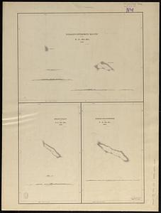
Deans, Krusensterns, and Lazareff Islands
44.
Deutschland, königr. der Niederlande, kgr. Belgien und die Schweiz, nebst theilen der angränzenden länder nach Adolf...
45.
Diagram of rail roads diverging from Boston : showing the depots and distances
46.
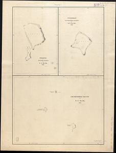
Disappointment Group ; Serle Island ; Clermont-Tonnere
47.
Dongguk yojido
48.
Eastern passages to China
49.
Eastern passages to China
50.
Eisen-bahn-karte von Deutschland und den angrenzenden ländern : zugleich als übersicht aller wichtigsten land- und...
51.
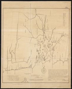
An exact plan of the sea coast of the continent from Paucatuck River eastwards to Point Judith and from thence northwards to...
52.
Extract from the plan of the coast survey of Boston Harbor, 1847
53.
Fakaafo or Bowditch Island ; Nuku-Nono or Duke of Clarence Island ; Oatáfu or Duke of York Island
54.
Fangaloa Bay, north side of Upolu
55.
Fayal Id., Horta and Pim Bays ; Azores, Fayal Channel
56.
Funafuti or Ellices Island ; Nukufetau or De Peysters Island ; De Peysters Group
57.
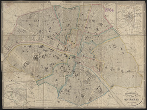
Galignani's plan of Paris and environs
58.
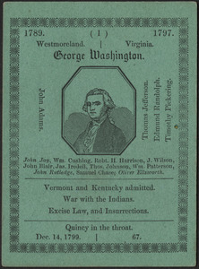
The game of American story and glory : [cards]
59.
Geognostische karte der umgebungen von Krems und vom Manhardsberge : jm flächenraume von 34 quadrat meilen
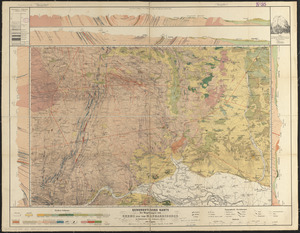
60.
Geographisches lottospiel, ganz neue vermehrte u. verbesserte auflage : durch welches sich die kinder spielend neit den...
‹ Prev
Next ›
1
2
3
4
5
6
7
…
12
13