Toggle navigation
LMEC Home
Exhibitions
Georeferencing
Tools for Teachers
Collections
My Favorites
Sign Up / Log In
Search
Search the map portal
Map Collection
Map Collection
Map Sets
Search
Search
Search for
Search In
All Fields
Creator
Title
Subject
Place
Search All Digital Collections
Advanced Search
57 Results
My Search
Start Over
Date
1710
to
1714
Remove constraint Date: <span class='from'>1710</span> to <span class='to'>1714</span>
Filter your Search
Place
North and Central America
31
United States
14
Europe
10
North America
8
South America
7
Canada
5
France
5
New York
4
more
Place
»
Topic
North America--Maps--Early works to 1800
5
South America--Maps--Early works to 1800
4
America--Maps--Early works to 1800
3
Western Hemisphere--Maps--Early works to 1800
3
Cape Verde--Maps--Early works to 1800
2
Connecticut--Boundaries--Massachusetts--Maps, Manuscript--Early works to 1800
2
Connecticut--Maps, Manuscript--Early works to 1800
2
Cuba--Maps--Early works to 1800
2
more
Topic
»
Date
1710
to
1714
[remove]
57
Date range begin
–
Date range end
Current results range from
1688
to
1800
1710
to
1710
34
1711
to
1711
34
1712
to
1712
30
1713
to
1713
36
1714
to
1714
34
Creator
Moll, Herman, d. 1732
8
Aa, Pieter van der, 1659-1733
4
Amherst, Jeffery Amherst, Baron, 1717-1797
2
Bissell, Henry W.
2
Bowles, John, 1701-1779
2
Burghers, M.
2
Chatelain, Henri Abraham.
2
Homann, Johann Baptist, 1663-1724
2
more
Creator
»
Format
Maps/Atlases
57
Manuscripts
3
Georeferenced
Yes
3
No
54
Collection
Norman B. Leventhal Map & Education Center Collection
40
American Revolutionary War-Era Maps
8
William L. Clements Library Collection
7
British Library Collection
6
Boston and New England Maps
4
Maritime Charts and Atlases
3
Urban Maps
3
MacLean Collection Map Library
2
more
Collection
»
Available to use
No known restrictions
40
Creative Commons license
8
Search Constraints
Sort by relevance
relevance
title
date (asc)
date (desc)
Number of results to display per page
20 per page
10
per page
20
per page
50
per page
100
per page
View results as:
grid view
map view
Search Results
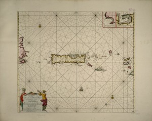
41.
Pas kaart van t eyland S. Iuan de Porto Rico, met d eylanden daar beoosten
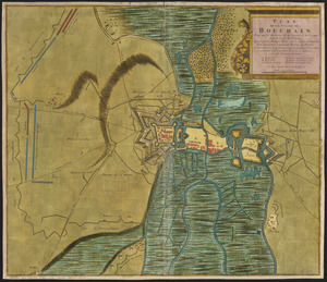
42.
Plan de la ville de Bouchain situé sur les rivieres de la Sensette, et de l'Escaut, dans le comté de Hainaut : assiegée par...
43.
Plan de la ville de Montreal en Canada levé en l'annee 1713
44.
Plan de la ville de Montreal en Canada levé en l'année 1713 et enceinte a Este rectifiée
45.
Regnorum Castellae novae, Andalusiae, Granadae, Valentiae, et Murciae, in episcopatus etc. divisorum
46.
River valley with several foothills and swamp
47.
Shinsen zouho Kyo oezu
48.
South America : corrected from the observation communicated to the Royal Societys of London & Paris
49.
Spagnvola
50.
Tabula Delphinatus et vicinarum regionum : distributa in principatus comitatus baronias &c. : cum usdem nominibus quae in...
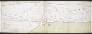
51.
This discription and [?] of the South Line of the Massachusetts Province which divides between the said Province and the Colony...
52.
This map of South America, according to the newest and most exact observations
53.
To the Right Honourable John Lord Sommers, Baron of Evesham in ye county of Worcester, president of Her Majesty's most...
54.
To the Right Honourable William, Lord Cowper, Lord High Chancellor of Great Britain, this map of Asia : according to ye newest...
55.
A tract of land granted to George Murray and Jacobas Bruyn lying & being in the county of Ulster on the west side of the Wall...
56.
Triangles on Mercator projection between St. Augustine and Cape Breton and St. Augustine and Cape Ortegal
57.
Virginia Marylandia et Carolina in America septentrionali Brittannorum industria excultæ
‹ Prev
Next ›
1
2
3
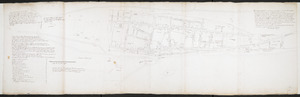


![This discription and [?] of the South Line of the Massachusetts Province which divides between the said Province and the Colony of Connecticut was made and Taken the Twenty Sixth day of October 1713 In Presence of Col. Samuel Partridge, Col. John Pynchon and [?] William Dudley Commissioners for the Massachusetts, and William Pithkin and William Whiting Esqrs for Connecticut wherein is discribed and Set down the Sain Line from Woodward and Saffery Station [?] to Connecticut River with the Several Towns farms and grants adjacent and Lying near the Same](https://bpldcassets.blob.core.windows.net/derivatives/images/commonwealth:hx11z566k/image_thumbnail_300.jpg)


