Toggle navigation
LMEC Home
Exhibitions
Georeferencing
Tools for Teachers
Collections
My Favorites
Sign Up / Log In
Search
Search the map portal
Map Collection
Map Collection
Map Sets
Search
Search
Search for
Search In
All Fields
Creator
Title
Subject
Place
Search All Digital Collections
Advanced Search
59 Results
My Search
Start Over
Date
1720
to
1724
Remove constraint Date: <span class='from'>1720</span> to <span class='to'>1724</span>
Filter your Search
Place
North and Central America
35
United States
16
North America
14
South America
11
Europe
9
New York
6
America
5
Louisiana
5
more
Place
»
Topic
North America--Maps--Early works to 1800
9
America--Maps--Early works to 1800
5
South America--Maps--Early works to 1800
5
Western Hemisphere--Maps--Early works to 1800
5
Manuscript maps--Early works to 1800
4
Louisiana--Maps--Early works to 1800
3
Mississippi River Valley--Maps--Early works to 1800
3
World maps--Early works to 1800
3
more
Topic
»
Date
1720
to
1724
[remove]
59
Date range begin
–
Date range end
Current results range from
1699
to
1800
1720
to
1720
44
1721
to
1721
30
1722
to
1722
26
1723
to
1723
27
1724
to
1724
25
Creator
Moll, Herman, d. 1732
11
Homann, Johann Baptist, 1663-1724
5
Senex, John, d. 1740
5
Bowen, Emanuel, 1693 or 1694-1767
3
L'Isle, Guillaume de, 1675-1726
3
Ogilby, John, 1600-1676
3
Bowles, John, 1701-1779
2
Bowles, Thomas, d. 1767
2
more
Creator
»
Format
Maps/Atlases
59
Manuscripts
8
Georeferenced
Yes
1
No
58
Collection
Norman B. Leventhal Map & Education Center Collection
41
American Revolutionary War-Era Maps
11
William L. Clements Library Collection
7
Boston and New England Maps
6
British Library Collection
3
Newberry Library Collection
3
Ralph Finos Map Collection at Phillips Academy
3
Mapping Boston Collection
2
more
Collection
»
Available to use
No known restrictions
42
Creative Commons license
6
Search Constraints
Sort by relevance
relevance
title
date (asc)
date (desc)
Number of results to display per page
20 per page
10
per page
20
per page
50
per page
100
per page
View results as:
grid view
map view
Search Results
21.
The harbour of Casco Bay and islands adjacent
22.
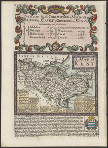
A map of Kent
23.
A map of lot no 1 in the Hardenbergh Patent
24.
A map of lot no 4 in the [Ha]rdenbergh Patent
25.
A map of Louisiana and of the River Mississipi
26.
A map of part of the Isthmus of Darien : shewing the communication with Panama, from Portobello & Chagre both by land, and by...
27.
A map of the East-Indies and the adjacent countries, with the settlements, factories and territories, explaning [sic] what...
28.
Mappmonde ou description generale du globe terrestre
29.
Naaukeurige platte grond van den staat loop van Rio de Berbice met derzelver plantagien in de geoctrojeerde colonie de Berbice
30.
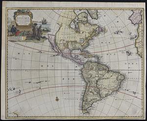
A new map of America from the latest observations
31.
A new map of Great Britain : according to the newest and most exact observations
32.
A new map of North America shewing its principal divisions, chief cities, townes, rivers, mountains &c
33.
A new map of the Baltick &c : shewing all the dominions about it with ye great or post roads and principal cross-roads
34.
A new map of the north parts of America claimed by France under ye names of Louisiana, Mississipi, Canada, and New France with...
35.
A new map of the north parts of America claimed by France under ye names of Louisiana, Mississipi, Canada, and New France with...
36.
A new map of the north parts of America claimed by France under ye names of Louisiana, Mississipi, Canada, and New France with...
37.
A new map of the terraqueous globe according to the latest discoveries and most general divisions of it into continents and oceans
38.
A new map of the world from the latest observations
39.
A new map of Virginia, Mary-land and the improved parts of Penn-sylvania & New Jersey
40.
Nouvelle carte de l'Amerique : avec tous ses royaumes, etats, iles, ports, bayes et rivieres, dressée suivant les plus...
‹ Prev
Next ›
1
2
3


![A map of lot no 4 in the [Ha]rdenbergh Patent](https://bpldcassets.blob.core.windows.net/derivatives/metadata/commonwealth-oai:zs262628v/image_thumbnail_300.jpg)


![A map of the East-Indies and the adjacent countries, with the settlements, factories and territories, explaning [sic] what belongs to England, Spain, France, Holland, Denmark, Portugal &c. with many remarks not extant in any other map](https://bpldcassets.blob.core.windows.net/derivatives/images/commonwealth:cj82ks68x/image_thumbnail_300.jpg)