Toggle navigation
LMEC Home
Exhibitions
Georeferencing
Tools for Teachers
Collections
My Favorites
Sign Up / Log In
Search
Search the map portal
Map Collection
Map Collection
Map Sets
Search
Search
Search for
Search In
All Fields
Creator
Title
Subject
Place
Search All Digital Collections
Advanced Search
48 Results
My Search
Start Over
Date
1658
Remove constraint Date: <span class='single'>1658</span>
Filter your Search
Place
Europe
36
England
29
France
4
North and Central America
4
South America
4
Africa
2
America
2
Asia
2
more
Place
»
Topic
America--Maps--Early works to 1800
3
Western Hemisphere--Maps--Early works to 1800
3
Rhône-Alpes (France)--Maps--Early works to 1800
2
Africa, West--Maps--Early works to 1800
1
Africa--Maps--Early works to 1800
1
Asia--Maps--Early works to 1800
1
Bedfordshire (England)--Maps--Early works to 1800
1
Brahe, Tycho, 1546-1601
1
more
Topic
»
Date
1658
[remove]
48
Date range begin
–
Date range end
Current results range from
1600
to
1699
1658
to
1658
48
Creator
Jansson, Jan, 1588-1664
34
Walton, Robert, 1618-1688
4
Danckerts, Justus, 1635-1701
2
Blaeu, Joan, 1596-1673
1
Blaeu, Willem Janszoon, 1571-1638
1
Duval, P. (Pierre), 1619-1682
1
Eckebrecht, Philipp, 1594-1667
1
Leclerc, Jean, active 1573-1627
1
more
Creator
»
Format
Maps/Atlases
48
Georeferenced
Yes
1
No
47
Collection
Norman B. Leventhal Map & Education Center Collection
46
Mapping Boston Collection
1
Ralph Finos Map Collection at Phillips Academy
1
Robert E. Diefenbach Map Collection at Phillips Academy
1
Available to use
No known restrictions
47
Creative Commons license
1
Search Constraints
Sort by relevance
relevance
title
date (asc)
date (desc)
Number of results to display per page
20 per page
10
per page
20
per page
50
per page
100
per page
View results as:
grid view
map view
Search Results
21.
Essexiae descriptio = The description of Essex
22.
Gallia vetus : ad Iul Caesaris commentaria ex conatibus geographicis
23.
Guiana sive Amazonum regio
24.
Hantoniae comitatus cum Bercheria
25.
Herefordia comitatus vernacule Hereford Shire
26.
Huntingdonensis comitatus Huntington Shire
27.
Insulae Americanae in Oceano Septentrionali, cum terris adiacentibus
28.
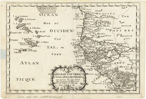
Isles de Cap Verd coste, et pays des Negres
29.
Lancastria palatinatus Anglis Lancaster & Lancas Shire
30.
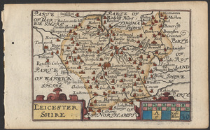
Leicestershire
31.
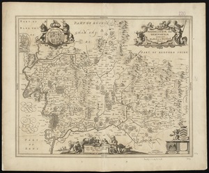
Leicestrensis comitatus cum Rutlandiae : vulgo Leicester & Rutland Shire
32.
Middelsexiae cum Hertfordiae comitatu : Midlesex & Hertford Shire
33.
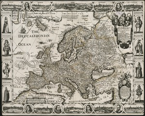
A new, plaine & exact map of Europe : described by N.I. Visscher and done into English, enlarged & corrected according to I....
34.
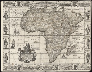
A new, plaine, & exact mapp of Africa : described by N.I. Visscher and done into English, enlarged and corrected, according to...
35.
A new, plaine, and exact map of America : described by N.I. Visscher, and don into English, enlarged, and corrected, according...
36.
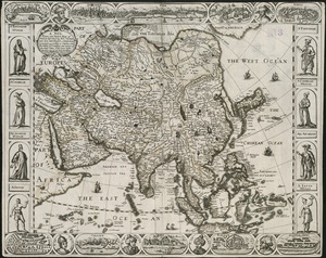
A new, plaine, and exact map of Asia : described by N.I. Visscher, and done into English, enlarged, and corrected, according to...
37.
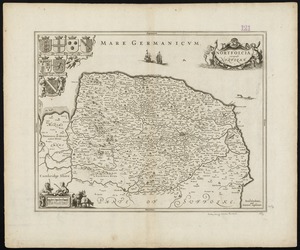
Nortfolcia : vernacule Norfolke
38.
Noua orbis terrarum delineatio singulari ratione accommodata meridiano tabb. Rudolphi astronomicarum
39.
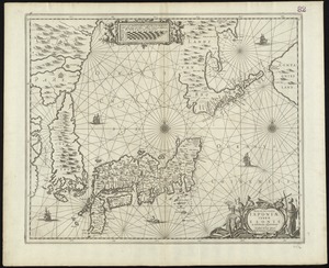
Nova et accvrata Iaponiae, terrae Esonis ac insularum adjacentium ex novissima detectione descriptio
40.
Recentissima novi orbis sive Americae septentrionalis et meridionalis tabula
‹ Prev
Next ›
1
2
3