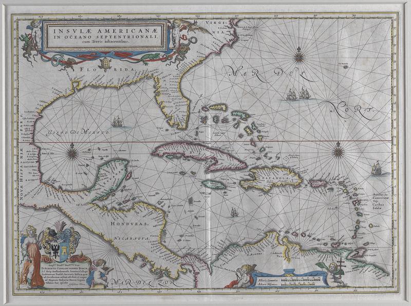
Insulae Americanae in Oceano Septentrionali, cum terris adiacentibus
Item Information
- Title:
- Insulae Americanae in Oceano Septentrionali, cum terris adiacentibus
- Cartographer:
- Blaeu, Willem Janszoon, 1571-1638
- Name on Item:
-
Guiljelmus Blaeu
- Date:
-
[ca. 1600–1699]
- Format:
-
Maps/Atlases
- Location:
-
Phillips Academy
Archives and Special Collections - Collection (local):
-
Robert E. Diefenbach Map Collection
- Places:
-
Caribbean Sea
West Indies
- Extent:
- 1 map ; 38 x 52 cm
- Terms of Use:
-
We believe that this item has no known US copyright restrictions. Though not required, if you want to credit us as the source, please use the following statement, "From The Trustees of Phillips Academy." Doing so helps us track how our collection is used and helps justify freely releasing even more content in the future.
This work is in the public domain under a Creative Commons No Rights Reserved License (CC0).
- Scale:
-
Scale not determined
- Language:
-
Latin
- Notes:
-
Title from item or accompanying material.
This map is hand colored.
Bar scale given in "milliaria Germanica" and "milliaria Hispanica."
- Notes (date):
-
Date from item or accompanying material.
- Identifier:
-
21_219_F_5