Noua orbis terrarum delineatio singulari ratione accommodata meridiano tabb. Rudolphi astronomicarum
Item Information
- Title:
- Noua orbis terrarum delineatio singulari ratione accommodata meridiano tabb. Rudolphi astronomicarum
- Description:
-
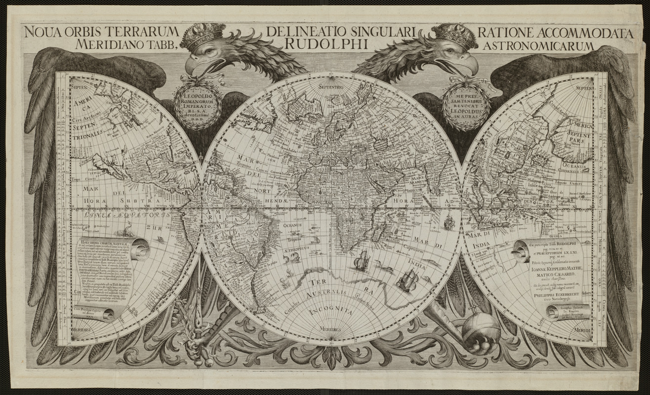
In this striking image, the world is portrayed on one full circle (or hemisphere), which is flanked by two half circles. This unusual geometrical configuration is embraced by a double-headed eagle. Realizing that this heraldic emblem is associated with the Holy Roman Empire provides a clue for the map's interpretation. The map was prepared by Philip Eckebrecht, a German merchant, at the request of the noted German astronomer Johannes Kepler to illustrate his published astronomical tables, which used celestial observations to determine longitude. Reflecting the scientific nature of this publication, the precisely drawn spheres are crisscrossed and numbered at regular intervals by a grid of latitude and longitude lines.However, the map also makes a statement about politics and patronage. While the central sphere, which covers the eagle's body, focuses on Europe, the entire world is embraced by the eagle, suggesting the wide extent of the empire to the east and west. More precisely, the full sphere is centered on the prime meridian that runs through Danish astronomer Tycho Brahe's observatory in Uraniborg, located on an island off the coast of Sweden. By using this meridian, Eckebrecht was able to place the core of the Holy Roman Empire (much of Germany and Austria) at the map's center and coincidentally near the eagle's heart. Both Brahe and Kepler received successive appointments as the royal mathematician and astronomer from Rudolf II, the Holy Roman Emperor and a member of the Habsburg dynasty. Not only were the map and tables dedicated to Rudolf when they were first published in 1630, but when the state of the map displayed here was reissued sometime after 1658, it was rededicated to a new emperor, Leopold I, also of Habsburg lineage.
- Creator:
- Eckebrecht, Philipp, 1594-1667
- Name on Item:
-
Petente typum[que] emblematis innuente Ioanne Kepplero, mathematico Caesareo amico chari[ss]imo, ita dis posuit suâ[que] manu exaravit ex sculi deni[que] fide integrâ curavit Philippus Eckebrecht civis Norimbergensis ; sumptus faciente Io: Kepplero, sculpsit Norimbergae
- Date:
-
[1658?]
- Format:
-
Maps/Atlases
- Location:
- Private Collection
- Collection (local):
-
Mapping Boston Collection
- Subjects:
-
World maps--Early works to 1800
Brahe, Tycho, 1546-1601
Kepler, Johannes, 1571-1630
Rudolf II, Holy Roman Emperor, 1552-1612
- Places:
-
World
- Extent:
- 1 map ; 39 x 68 cm.
- Terms of Use:
-
No known copyright restrictions.
This work is licensed for use under a Creative Commons Attribution Non-Commercial Share Alike License (CC BY-NC-SA).

- Publisher:
-
Ulm :
s.n.
- Scale:
-
Scale not given
- Language:
-
Latin
- Notes:
-
Relief shown pictorially.
- Notes (exhibitions):
-
Exhibited in “Journeys of the Imagination,” at the Boston Public Library, Boston, MA, April - August 2006.
Exhibited: "Unconventional Maps: Exploring the Stories of Cartographic Curiosities" organized by the Norman B. Leventhal Map Center at the Boston Public Library, 2011-2012.
- Identifier:
-
05_01_000220
- Barcode:
-
39999052509567


![Hemispheriu[m] ab aequinoctiali linea, ad circulu[m] Poli Arctici](https://bpldcassets.blob.core.windows.net/derivatives/images/commonwealth:3f462s45p/image_thumbnail_300.jpg)

