Toggle navigation
LMEC Home
Exhibitions
Georeferencing
Tools for Teachers
Collections
My Favorites
Sign Up / Log In
Search
Search the map portal
Map Collection
Map Collection
Map Sets
Search
Search
Search for
Search In
All Fields
Creator
Title
Subject
Place
Search All Digital Collections
Advanced Search
40 Results
My Search
Start Over
Date
1942
Remove constraint Date: <span class='single'>1942</span>
Filter your Search
Place
North and Central America
18
United States
17
Massachusetts
7
Asia
6
Boston
6
Suffolk (county)
6
Europe
5
New England
5
more
Place
»
Topic
Boston (Mass.)--Maps
3
Morocco--Maps
3
New England--Maps--Early works to 1800--Facsimiles
3
China--Maps
2
Europe--Maps
2
Freight and freightage--Germany--Maps
2
Germany--Maps
2
United States--Maps
2
more
Topic
»
Date
1942
[remove]
40
Date range begin
–
Date range end
Current results range from
1770
to
1999
1942
to
1942
40
Creator
United States. Office of Strategic Services. Geography Division
13
Chase, Ernest Dudley, 1878-1966
3
Bridge, Edward Melville, 1890-
2
Wakefield Item Company
2
Boston (Mass.). Department of Parks. Board of Commissioners
1
Boston Elevated Railway Company
1
British Information Services
1
Buck Printing Co.
1
more
Creator
»
Format
Maps/Atlases
38
Photographs
1
Prints
1
Georeferenced
Yes
3
No
37
Collection
Norman B. Leventhal Map & Education Center Collection
36
Boston and New England Maps
2
Lucius Beebe Memorial Library Historic Maps
2
American Revolutionary War-Era Maps
1
Maritime Charts and Atlases
1
Ralph Finos Map Collection at Phillips Academy
1
Sidney R. Knafel Map Collection at Phillips Academy
1
Urban Maps
1
Available to use
No known restrictions
39
Search Constraints
Sort by relevance
relevance
title
date (asc)
date (desc)
Number of results to display per page
20 per page
10
per page
20
per page
50
per page
100
per page
View results as:
grid view
map view
Search Results
1.
38,000,000 escaped -- 10,000,000 died
2.
Agricultural areas of China
3.
Boston Elevated Railway system route map
4.
Boston, Massachusetts
5.
The British Commonwealth of Nations
6.
A chart of the gulf stream
7.
China : waterways and stage routes
8.
A draught of St. John's harbour : with the soundings
9.
Family of Mrs. Donovan, Roxbury
10.
French Morocco port traffic, 1938
11.
Germany, main movements of freight traffic
12.
Germany, main movements of freight traffic, 1942
13.
The good neighbor pictorial map of South America
14.
Japanese fishing, areas and seasons
15.
Land utilization in Korea
16.
A map of New England and New York
17.
Map of the Back Bay Fens showing the public ways bordering and crossing them and the neighboring newly laid out parts of...
18.
A mapp of New England
19.
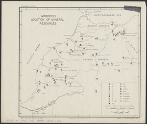
Morocco, location of mineral resources
20.
Philippine Islands population, 1939 census
‹ Prev
Next ›
1
2