Toggle navigation
LMEC Home
Exhibitions
Georeferencing
Tools for Teachers
Collections
My Favorites
Sign Up / Log In
Search
Search the map portal
Map Collection
Map Collection
Map Sets
Search
Search
Search for
Search In
All Fields
Creator
Title
Subject
Place
Search All Digital Collections
Advanced Search
1227 Results
My Search
Start Over
More Like
commonwealth-oai:xk81pj70h
Remove constraint More Like: commonwealth-oai:xk81pj70h
Filter your Search
Place
North and Central America
1,192
United States
933
Canada
226
New York
193
Quebec
111
Pennsylvania
61
New Jersey
54
Nova Scotia
48
more
Place
»
Topic
United States--Maps
330
United States--History--Revolution, 1775-1783--Maps
305
United States--History--French and Indian War, 1754-1763--Maps
151
Saint Lawrence River--Maps
44
Elections--United States--Maps
36
Railroads--United States--Maps
34
Canada--Maps
29
Newport (R.I.)--Maps
27
more
Topic
»
Date
Date range begin
–
Date range end
Current results range from
1700
to
2023
View distribution
Creator
Paullin, Charles Oscar, 1868 or 1869-1944
70
Wright, John Kirtland, 1891-1969
70
Rocque, Mary Ann
29
Bellin, Jacques Nicolas, 1703-1772
26
Holland, Samuel, 1728-1801
25
Montrésor, John, 1736-1799
25
Jefferys, Thomas, -1771
24
Clinton, Henry, Sir, 1738?-1795
19
more
Creator
»
Format
Maps/Atlases
1,209
Drawings/Illustrations
11
Documents
5
Prints
3
Books
1
Manuscripts
1
Objects/Artifacts
1
Posters
1
Georeferenced
Yes
65
No
1,162
Collection
American Revolutionary War-Era Maps
939
William L. Clements Library Collection
909
Norman B. Leventhal Map & Education Center Collection
288
American Antiquarian Society Collection
20
MacLean Collection Map Library
9
David Judkins Weaver Papers
2
Mapping Boston Collection
2
Applied Geographics, Inc. Records
1
more
Collection
»
Available to use
No known restrictions
213
Creative Commons license
5
Search Constraints
Sort by relevance
relevance
title
date (asc)
date (desc)
Number of results to display per page
20 per page
10
per page
20
per page
50
per page
100
per page
View results as:
grid view
map view
Search Results
461.
Crown Point to Fort Edward, New York
462.
Dartmouth
463.
The Delancey lands on Manhattan Island
464.
Delaware Bay and Chesapeake Bay
465.
Delaware Bay and Chesapeake Bay
466.
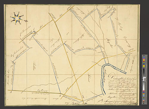
Discription [sic] of the roads about White Plains
467.
Disposition of the British forces before Charleston 1780
468.
Disposition of the British forces on Long Island, Staten Island, and Manhattan Island, under Cornwallis and Knyphausen
469.
Distances North River
470.
Distribution & strength of corps 1780
471.
The district of Main from the latest surveys
472.
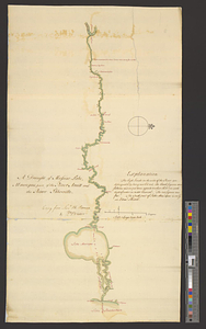
A draft of the Nerernanset shore from the entrance to the mouth of Potewomet River northward and from the Nererganset Bay to...
473.
A draft of the Ohio from an Indian account
474.
A draught of a route from Québec to Fort Halifax on the River Kennebec and back again to Québec by the rivers Chaudière and...
475.
Draught of a tract of land situate in Bucks County, in the Commonwealth of Pennsylvania divided in three parts, called...
476.
A draught of Massiac Lake, Maurepas, part of the river Amitt and the river Ibberville : copy from Lieut Ph: Pittman
477.
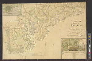
Draught of part of the province of South Carolina shewing the march & encampments of the British troops under the command of...
478.
A draught of Rhode Island, 1777
479.
A draught of Ship & Catt islands and the opposite coast
480.
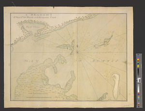
A draught of the barr off Mobile & Dauphine Island
‹ Prev
Next ›
1
2
…
20
21
22
23
24
25
26
27
28
…
61
62


![Discription [sic] of the roads about White Plains](https://bpldcassets.blob.core.windows.net/derivatives/metadata/commonwealth-oai:w3767301r/image_thumbnail_300.jpg)