Toggle navigation
LMEC Home
Exhibitions
Georeferencing
Tools for Teachers
Collections
My Favorites
Sign Up / Log In
Search
Search the map portal
Map Collection
Map Collection
Map Sets
Search
Search
Search for
Search In
All Fields
Creator
Title
Subject
Place
Search All Digital Collections
Advanced Search
953 Results
My Search
Start Over
More Like
commonwealth-oai:st74hp42z
Remove constraint More Like: commonwealth-oai:st74hp42z
Filter your Search
Place
North and Central America
913
United States
637
Canada
221
New York
193
Quebec
114
Saint Lawrence River
66
Pennsylvania
60
New Jersey
54
more
Place
»
Topic
United States--History--Revolution, 1775-1783--Maps
305
United States--History--French and Indian War, 1754-1763--Maps
162
Saint Lawrence River--Maps
67
Newport (R.I.)--Maps
27
Québec (Québec)--Maps
27
New York (State)--Maps
25
Hudson River (N.Y. and N.J.)--Maps
21
Louisbourg (N.S.)--Maps
20
more
Topic
»
Date
Date range begin
–
Date range end
Current results range from
1700
to
1900
View distribution
Creator
Jefferys, Thomas, -1771
30
Holland, Samuel, 1728-1801
29
Montrésor, John, 1736-1799
29
Rocque, Mary Ann
29
Bellin, Jacques Nicolas, 1703-1772
28
Clinton, Henry, Sir, 1738?-1795
19
Robert Sayer and John Bennett (Firm)
16
Orme, Robert, -1781
14
more
Creator
»
Format
Maps/Atlases
937
Drawings/Illustrations
11
Documents
5
Manuscripts
1
Prints
1
Georeferenced
No
953
Collection
American Revolutionary War-Era Maps
948
William L. Clements Library Collection
909
Library and Archives Canada Collection
19
Norman B. Leventhal Map & Education Center Collection
9
American Antiquarian Society Collection
5
Richard H. Brown Revolutionary War Map Collection at Mount Vernon
4
MacLean Collection Map Library
3
New York Public Library Collection
3
more
Collection
»
Available to use
No known restrictions
10
Creative Commons license
7
Search Constraints
Sort by relevance
relevance
title
date (asc)
date (desc)
Number of results to display per page
20 per page
10
per page
20
per page
50
per page
100
per page
View results as:
grid view
map view
Search Results
301.
Charleston and the British attack of June 1776
302.
Charlestown, Breed's Hill, and Bunker Hill
303.
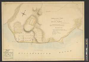
Charlotte Town the capital of the island of St. John
304.
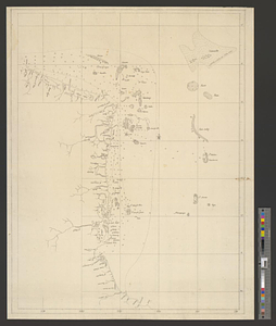
Chart of the coast of Honduras and Nicaragua
305.
Chart of the east coast of the Yucatan
306.
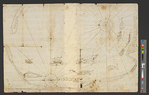
A chart of the harbour of Rhode Island and Narraganset Bay surveyed in pursuance of directions from the Lords of Trade to His...
307.
A chart of the harbour of Rhode Island and Narraganset Bay surveyed in pursuance of directions from the Lords of Trade to his...
308.
A chart of the harbour of Rhode Island and Narraganset Bay surveyed in pursuance of directions from the Lords of Trade to his...
309.
A chart of the peninsula of Nova Scotia
310.
A chart of Tibee Inlet in Georgia
311.
A chart shewing the tract of Capt. Cook's last voyage, 1799
312.
A chorographical map of the country round Philadelphia = Carte particuliere des environs de Philadelphia
313.
A chorographical map of the northern department of North-America : drawn from the latest and most accurate observations
314.
City of St. Augustine and environs
315.
The coast from St. Johns, New Brunswick, to Goldsborough Bay, Maine
316.
The coast of Maine from modern Portland to Desert Island
317.
Coast of Senegal
318.
Ye commencement for draft of New York Island
319.
The communication between the Iberville and the river Mississippe
320.
A compleat plan of part of the province of Pennsylvania East and West Jersey shewing the transactions of the royal army under...
‹ Prev
Next ›
1
2
…
12
13
14
15
16
17
18
19
20
…
47
48