Toggle navigation
LMEC Home
Exhibitions
Georeferencing
Tools for Teachers
Collections
My Favorites
Sign Up / Log In
Search
Search the map portal
Map Collection
Map Collection
Map Sets
Search
Search
Search for
Search In
All Fields
Creator
Title
Subject
Place
Search All Digital Collections
Advanced Search
1253 Results
My Search
Start Over
More Like
commonwealth-oai:pv63kz90b
Remove constraint More Like: commonwealth-oai:pv63kz90b
Filter your Search
Place
North and Central America
1,221
United States
960
Canada
227
New York
193
Quebec
111
Pennsylvania
61
New Jersey
57
Massachusetts
53
more
Place
»
Topic
United States--History--Revolution, 1775-1783--Maps
330
United States--Maps
330
United States--History--French and Indian War, 1754-1763--Maps
151
Saint Lawrence River--Maps
44
Elections--United States--Maps
36
Railroads--United States--Maps
34
Canada--Maps
29
Newport (R.I.)--Maps
27
more
Topic
»
Date
Date range begin
–
Date range end
Current results range from
1700
to
2023
View distribution
Creator
Paullin, Charles Oscar, 1868 or 1869-1944
70
Wright, John Kirtland, 1891-1969
70
Rocque, Mary Ann
29
Bellin, Jacques Nicolas, 1703-1772
26
Holland, Samuel, 1728-1801
25
Jefferys, Thomas, -1771
25
Montrésor, John, 1736-1799
25
Clinton, Henry, Sir, 1738?-1795
19
more
Creator
»
Format
Maps/Atlases
1,235
Drawings/Illustrations
11
Documents
5
Manuscripts
5
Prints
3
Books
1
Objects/Artifacts
1
Posters
1
Georeferenced
Yes
67
No
1,186
Collection
American Revolutionary War-Era Maps
959
William L. Clements Library Collection
909
Norman B. Leventhal Map & Education Center Collection
296
Maps from AAS
27
MacLean Collection Map Library
11
Boston and New England Maps
5
Newberry Library Collection
3
Urban Maps
3
more
Collection
»
Available to use
No known restrictions
223
Creative Commons license
9
Search Constraints
Sort by relevance
relevance
title
date (asc)
date (desc)
Number of results to display per page
20 per page
10
per page
20
per page
50
per page
100
per page
View results as:
grid view
map view
Search Results
1181.
A rough sketch of the field of battle, near Turtle Creek, of the 9th July, with the disposition of the British troops, and...
1182.
A rude sketch of a part of the road between the township of Horton and Granville on the river of Annapolis, relative to a...
1183.
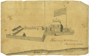
S. east view of Fort St. Tammany : N. Hayward to Major H. Burbeck
1184.
Saml Wath to Abel Richardson : Wm Foster to James Foster exec ditto
1185.
Sault aux Recollets
1186.
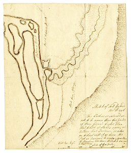
Scetch [sic] of the blockhouse at the east of Oneda Lake
1187.
Section of the level of the country
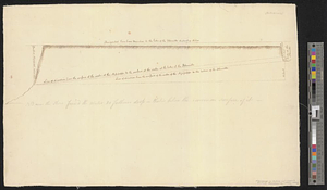
1188.
The Seven Islands and the Bay
1189.
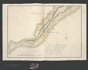
The Shoals of Beauport; The River St. Lawrence from the Basin of Quebec to the Falls of Richeu
1190.
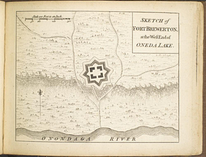
Sketch of Fort Brewerton at the west end of Oneda Lake
1191.
Sketch of Fort Edward, Novr. 30th, 1756
1192.
A sketch of part of the river St. John on the north side of the Bay of Fundy from Partridge Island in the latitude of 45.22...
1193.
Sketch of Presque Isle
1194.
Sketch of the country from Fort Du Quesne to Niagara as described by an intelligent Indian who had resided there for a...
1195.
Sketch of the country round Tyconderoga
1196.
A sketch of the entrance from the sea to Apalachy and part of the environs
1197.
Sketch of the environs of Charlotteville
1198.
Sketch of the fort at Michilimackinac
1199.
A sketch of the harbour at the Cape Slt: Nicola on the island of Hispaniola
1200.
A sketch of the river Missisippi from New Orleans to the Rock of Davion
‹ Prev
Next ›
1
2
…
56
57
58
59
60
61
62
63

![Scetch [sic] of the blockhouse at the east of Oneda Lake](https://bpldcassets.blob.core.windows.net/derivatives/metadata/commonwealth-oai:zs2626251/image_thumbnail_300.jpg)