Toggle navigation
LMEC Home
Exhibitions
Georeferencing
Tools for Teachers
Collections
My Favorites
Sign Up / Log In
Search
Search the map portal
Map Collection
Map Collection
Map Sets
Search
Search
Search for
Search In
All Fields
Creator
Title
Subject
Place
Search All Digital Collections
Advanced Search
976 Results
My Search
Start Over
More Like
commonwealth-oai:j96060056
Remove constraint More Like: commonwealth-oai:j96060056
Filter your Search
Place
North and Central America
950
United States
684
Canada
206
New York
197
Quebec
111
Rhode Island
79
Massachusetts
71
Pennsylvania
61
more
Place
»
Topic
United States--History--Revolution, 1775-1783--Maps
305
United States--History--French and Indian War, 1754-1763--Maps
149
Rhode Island--Maps
50
Saint Lawrence River--Maps
43
Connecticut--Maps
41
Massachusetts--Maps
39
New York (State)--Maps
27
Newport (R.I.)--Maps
27
more
Topic
»
Date
Date range begin
–
Date range end
Current results range from
1700
to
1990
View distribution
Creator
Rocque, Mary Ann
29
Holland, Samuel, 1728-1801
25
Montrésor, John, 1736-1799
25
Bellin, Jacques Nicolas, 1703-1772
24
Jefferys, Thomas, -1771
24
Clinton, Henry, Sir, 1738?-1795
19
Robert Sayer and John Bennett (Firm)
15
Hills, John, active 1777-1819
13
more
Creator
»
Format
Maps/Atlases
960
Drawings/Illustrations
11
Documents
5
Manuscripts
1
Prints
1
Georeferenced
Yes
19
No
957
Collection
American Revolutionary War-Era Maps
917
William L. Clements Library Collection
909
Norman B. Leventhal Map & Education Center Collection
60
Boston and New England Maps
46
David Judkins Weaver Papers
6
American Antiquarian Society Collection
5
Sidney R. Knafel Map Collection at Phillips Academy
2
Applied Geographics, Inc. Records
1
more
Collection
»
Available to use
No known restrictions
59
Creative Commons license
1
Search Constraints
Sort by relevance
relevance
title
date (asc)
date (desc)
Number of results to display per page
20 per page
10
per page
20
per page
50
per page
100
per page
View results as:
grid view
map view
Search Results
941.
Town of Three Rivers
942.
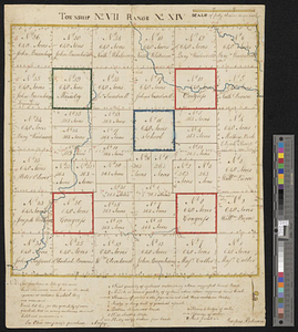
Township no. VII range no. XIV
943.
A tract of land granted to George Murray and Jacobas Bruyn lying & being in the county of Ulster on the west side of the Wall...
944.
Triangles on Mercator projection between St. Augustine and Cape Breton and St. Augustine and Cape Ortegal
945.
The United States according to the definitive treaty of peace signed at Paris, Septr. 3d. 1783 ...
946.
United States of America
947.
The United States of America
948.
The United States of America laid down from the best authorities, agreeable to the peace of 1783
949.
The United States of America with the British possessions of Canada, Nova Scotia, New Brunwsick, and Newfoundland, divided with...
950.
The United States of North America with the British & Spanish territories according to the treaty
951.
Upper Canada and the Great Lakes region
952.
Upper New York, Vermont, and Massachusetts
953.
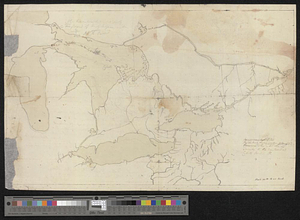
Upper Salem and part of the tounds [sic] joining it for two or three miles distance
954.
Valley of the Hudson River from Fishkill to Teller's Point
955.
Verplanks
956.
Verplanks Point
957.
View from the blockhouse : Dorchester Neck
958.
View of Dorchester Neck from Enoch Brown's
959.
View of Dorchester Neck, from the mess house on Fort Hill
960.
View of Dorchester Neck, from the mess house on Fort Hill
‹ Prev
Next ›
1
2
…
44
45
46
47
48
49


![Upper Salem and part of the tounds [sic] joining it for two or three miles distance](https://bpldcassets.blob.core.windows.net/derivatives/metadata/commonwealth-oai:8k71sf77k/image_thumbnail_300.jpg)


