Toggle navigation
LMEC Home
Exhibitions
Georeferencing
Tools for Teachers
Collections
My Favorites
Sign Up / Log In
Search
Search the map portal
Map Collection
Map Collection
Map Sets
Search
Search
Search for
Search In
All Fields
Creator
Title
Subject
Place
Search All Digital Collections
Advanced Search
924 Results
My Search
Start Over
More Like
commonwealth-oai:h415t824z
Remove constraint More Like: commonwealth-oai:h415t824z
Filter your Search
Place
North and Central America
894
United States
636
Canada
209
New York
193
Quebec
112
Pennsylvania
60
New Jersey
54
Nova Scotia
48
more
Place
»
Topic
United States--History--Revolution, 1775-1783--Maps
305
United States--History--French and Indian War, 1754-1763--Maps
162
Saint Lawrence River--Maps
43
Newport (R.I.)--Maps
27
New York (State)--Maps
25
Hudson River (N.Y. and N.J.)--Maps
21
Québec (Québec)--Maps
21
Louisbourg (N.S.)--Maps
20
more
Topic
»
Date
Date range begin
–
Date range end
Current results range from
1700
to
1900
View distribution
Creator
Rocque, Mary Ann
29
Jefferys, Thomas, -1771
28
Holland, Samuel, 1728-1801
25
Montrésor, John, 1736-1799
25
Bellin, Jacques Nicolas, 1703-1772
24
Clinton, Henry, Sir, 1738?-1795
19
Robert Sayer and John Bennett (Firm)
15
Orme, Robert, -1781
14
more
Creator
»
Format
Maps/Atlases
908
Drawings/Illustrations
11
Documents
5
Prints
1
Georeferenced
No
924
Collection
American Revolutionary War-Era Maps
923
William L. Clements Library Collection
909
Norman B. Leventhal Map & Education Center Collection
5
Richard H. Brown Revolutionary War Map Collection at Mount Vernon
4
Maps from AAS
3
Library and Archives Canada Collection
1
MacLean Collection Map Library
1
New-York Historical Society Collection
1
Available to use
No known restrictions
6
Creative Commons license
4
Search Constraints
Sort by relevance
relevance
title
date (asc)
date (desc)
Number of results to display per page
20 per page
10
per page
20
per page
50
per page
100
per page
View results as:
grid view
map view
Search Results
1.
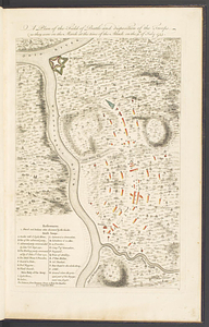
A plan of the field of battle and disposition of the troops, as they were on the march at the time of the attack on the 9th of...
2.
Ein grund-ris von der Festung Duquesne ...
3.
Plan of Fort le Quesne, built by the French at the fort of the Ohio and monongahela in 1754
4.
Sketch of the country from Fort Du Quesne to Niagara as described by an intelligent Indian who had resided there for a...
5.
A map of the country between Will's Creek & Monongahela River shewing the rout and encampments of the English army, in 1755
6.
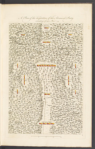
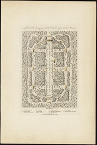
A plan of the disposition of the advanced party, consisting of 400 men
7.
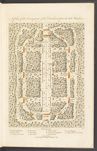
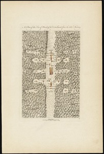
A plan of the encampment of the detachment from the Little Meadows
8.
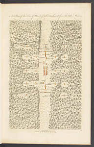
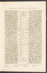
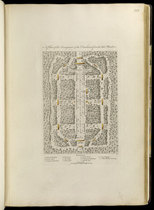
A plan of the line of march of the detachment from the Little Meadows
9.
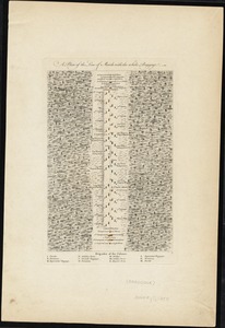
A plan of the line of march with the whole baggage
10.
A plan of the disposition of the advanced party consisting of 400 men : to defend the workers in making the road
11.
A plan of the disposition of the advanced party consisting of 400 men : to defend the workers in making the road
12.
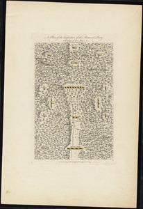
A plan of the encampment of the detachment from the little Meadows
13.
A plan of the encampment of the detachment from the little Meadows
14.
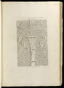
A plan of the line of march of the detachment from the little Meadows
15.
A plan of the line of march of the detachment from the little Meadows
16.
A plan of the line of march with the whole baggage
17.
A plan of the line of march with the whole baggage
18.
An accurate map of Canada, with the adjacent countries; exhibiting the late seat of war between the English & French in those...
19.
Attaques des forts de Chouaguen en Amérique pris par les français commandés par le Marquis de Montcalm le 14 Août 1756
20.
Attaques des retranchemens devant le fort Carillon en Amérique par les anglais commandés par le général Abercrombie contre les...
‹ Prev
Next ›
1
2
3
4
5
…
46
47