Toggle navigation
LMEC Home
Exhibitions
Georeferencing
Tools for Teachers
Collections
My Favorites
Sign Up / Log In
Search
Search the map portal
Map Collection
Map Collection
Map Sets
Search
Search
Search for
Search In
All Fields
Creator
Title
Subject
Place
Search All Digital Collections
Advanced Search
1254 Results
My Search
Start Over
More Like
commonwealth-oai:g158gg63r
Remove constraint More Like: commonwealth-oai:g158gg63r
Filter your Search
Place
North and Central America
1,224
United States
942
Canada
251
New York
196
Quebec
112
Pennsylvania
61
New Jersey
54
Nova Scotia
49
more
Place
»
Topic
United States--Maps
330
United States--History--Revolution, 1775-1783--Maps
305
United States--History--French and Indian War, 1754-1763--Maps
152
Canada--Maps
55
Saint Lawrence River--Maps
44
Elections--United States--Maps
36
Railroads--United States--Maps
34
New York (State)--Maps
27
more
Topic
»
Date
Date range begin
–
Date range end
Current results range from
1700
to
2023
View distribution
Creator
Paullin, Charles Oscar, 1868 or 1869-1944
70
Wright, John Kirtland, 1891-1969
70
Rocque, Mary Ann
29
Bellin, Jacques Nicolas, 1703-1772
26
Holland, Samuel, 1728-1801
25
Montrésor, John, 1736-1799
25
Jefferys, Thomas, -1771
24
Clinton, Henry, Sir, 1738?-1795
19
more
Creator
»
Format
Maps/Atlases
1,236
Drawings/Illustrations
11
Documents
5
Prints
3
Books
1
Manuscripts
1
Objects/Artifacts
1
Posters
1
Georeferenced
Yes
67
No
1,187
Collection
American Revolutionary War-Era Maps
942
William L. Clements Library Collection
909
Norman B. Leventhal Map & Education Center Collection
312
Maps from AAS
23
MacLean Collection Map Library
9
Boston and New England Maps
2
David Judkins Weaver Papers
2
Mapping Boston Collection
2
more
Collection
»
Available to use
No known restrictions
237
Creative Commons license
5
Search Constraints
Sort by relevance
relevance
title
date (asc)
date (desc)
Number of results to display per page
20 per page
10
per page
20
per page
50
per page
100
per page
View results as:
grid view
map view
Search Results
41.
United States of America
42.
The United States of America
43.
The United States of America laid down from the best authorities, agreeable to the peace of 1783
44.
The United States of America with the British possessions of Canada, Nova Scotia, New Brunwsick, and Newfoundland, divided with...
45.
British America, comprehending Canada, Labrador, New-Foundland, Nova Scotia &c
46.
British possessions in North America
47.
The British possessions in North America from the best authorities
48.
The British possessions in North America from the best authorities
49.
Canada and Nova Scotia
50.
Canada and Nova Scotia
51.
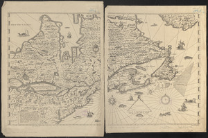
Carte de la Nouvelle-France, augmentée depuis la derniere, servant a la navigation faicte en son vray Meridien par le Sr. de...
52.
Coal areas of Canada
53.
Dawson's map of the Dominion of Canada
54.
Dominion of Canada
55.
E.P. Dutton & Co.'s railroad, steam boat & stage route map of New England, New-York and Canada
56.
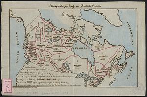
Ethnographische karte von Britisch America : verbreitung der indianer
57.
Government map of part of the Huron and Ottawa Territory, Ontario
58.
L'Isle de Terre-Neuve, l'Acadie, ou la Nouvelle Ecosse, : l'Isle St. Jean et la partie orientale du Canada
59.
A map of Canada
60.
A Map of that part of America which was the principal seat of war in 1756
‹ Prev
Next ›
1
2
3
4
5
6
7
…
62
63