Toggle navigation
LMEC Home
Exhibitions
Georeferencing
Tools for Teachers
Collections
My Favorites
Sign Up / Log In
Search
Search the map portal
Map Collection
Map Collection
Map Sets
Search
Search
Search for
Search In
All Fields
Creator
Title
Subject
Place
Search All Digital Collections
Advanced Search
1254 Results
My Search
Start Over
More Like
commonwealth-oai:g158gg63r
Remove constraint More Like: commonwealth-oai:g158gg63r
Filter your Search
Place
North and Central America
1,224
United States
942
Canada
251
New York
196
Quebec
112
Pennsylvania
61
New Jersey
54
Nova Scotia
49
more
Place
»
Topic
United States--Maps
330
United States--History--Revolution, 1775-1783--Maps
305
United States--History--French and Indian War, 1754-1763--Maps
152
Canada--Maps
55
Saint Lawrence River--Maps
44
Elections--United States--Maps
36
Railroads--United States--Maps
34
New York (State)--Maps
27
more
Topic
»
Date
Date range begin
–
Date range end
Current results range from
1700
to
2023
View distribution
Creator
Paullin, Charles Oscar, 1868 or 1869-1944
70
Wright, John Kirtland, 1891-1969
70
Rocque, Mary Ann
29
Bellin, Jacques Nicolas, 1703-1772
26
Holland, Samuel, 1728-1801
25
Montrésor, John, 1736-1799
25
Jefferys, Thomas, -1771
24
Clinton, Henry, Sir, 1738?-1795
19
more
Creator
»
Format
Maps/Atlases
1,236
Drawings/Illustrations
11
Documents
5
Prints
3
Books
1
Manuscripts
1
Objects/Artifacts
1
Posters
1
Georeferenced
Yes
67
No
1,187
Collection
American Revolutionary War-Era Maps
942
William L. Clements Library Collection
909
Norman B. Leventhal Map & Education Center Collection
312
Maps from AAS
23
MacLean Collection Map Library
9
Boston and New England Maps
2
David Judkins Weaver Papers
2
Mapping Boston Collection
2
more
Collection
»
Available to use
No known restrictions
237
Creative Commons license
5
Search Constraints
Sort by relevance
relevance
title
date (asc)
date (desc)
Number of results to display per page
20 per page
10
per page
20
per page
50
per page
100
per page
View results as:
grid view
map view
Search Results
21.
A new map of the British empire in Nth. America
22.
Partie occidentale du Canada, : contenant les cinq Grands Lacs, avec les pays circonvoisins
23.
Relief map of Canada and the United States
24.
Schonberg's imperial map of the United States and Canada : constructed, drawn and compiled from the latest and best authorities...
25.
Trans-continental map : showing the main lines and proposed extensions of the various trans-continental railroad systems of the...
26.
An accurate map of Canada, with the adjacent countries; exhibiting the late seat of war between the English & French in those...
27.
Canada
28.
Carte du Golphe de St. Laurent et pays voisins pour servir à l'histoire générale des voyages
29.
A map of New England, and Nova Scotia; with part of New York, Canada, and New Britain & the adjacent islands of New Found Land...
30.
A new and accurate map of the present seat of war in North America
31.
A new map of Canada, also the north parts of New England and New York; with Nova Scotia and Newfound Land
32.
La Nouvelle France ou Canada
33.
Cantonment of the forces in N. America 1766
34.
Eastern section of the United States
35.
Etats Unis de l'Amerique
36.
A map of the United States
37.
A map of the United States east of the Mississippi River in which the land ceded by the Treaty of Paris is divided by parallels...
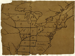
38.
A map of the United States east of the Mississippi River in which the land ceded by the Treaty of Paris is divided by parallels...
39.
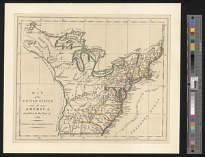
A map of the United States of America as settled by the peace of 1783
40.
The United States according to the definitive treaty of peace signed at Paris, Septr. 3d. 1783 ...
‹ Prev
Next ›
1
2
3
4
5
6
…
62
63