Toggle navigation
LMEC Home
Exhibitions
Georeferencing
Tools for Teachers
Collections
My Favorites
Sign Up / Log In
Search
Search the map portal
Map Collection
Map Collection
Map Sets
Search
Search
Search for
Search In
All Fields
Creator
Title
Subject
Place
Search All Digital Collections
Advanced Search
339 Results
My Search
Start Over
More Like
commonwealth:z603vv407
Remove constraint More Like: commonwealth:z603vv407
Filter your Search
Place
North and Central America
272
United States
210
Suffolk (county)
74
Boston
72
Massachusetts
40
New York
32
Canada
28
North America
27
more
Place
»
Topic
Boston (Mass.)--Maps--Early works to 1800
48
Boston Harbor (Mass.)--Maps--Early works to 1800
22
Boston (Mass.)--History--Revolution, 1775-1783--Maps--Early works to 1800
19
North America--Maps--Early works to 1800
18
New England--Maps--Early works to 1800
11
United States--History--Revolution, 1775-1783--Maps--Early works to 1800
11
Vues d'optique
10
Bunker Hill, Battle of, Boston, Mass., 1775--Maps--Early works to 1800
9
more
Topic
»
Date
Date range begin
–
Date range end
Current results range from
1694
to
1879
View distribution
Creator
Faden, William, 1749-1836
33
Jefferys, Thomas, -1771
30
Le Rouge, Georges-Louis
24
Des Barres, Joseph F. W. (Joseph Frederick Wallet), 1722-1824
22
Sayer, Robert, 1725-1794
19
Korn, Christoph Heinrich, 1726-1783
11
Raspe, Gabriel Nicolaus, 1712-1785
11
Simcoe, John Graves, 1752-1806
10
more
Creator
»
Format
Maps/Atlases
296
Prints
32
Manuscripts
25
Drawings/Illustrations
9
Books
2
Georeferenced
Yes
18
No
321
Collection
American Revolutionary War-Era Maps
329
Richard H. Brown Revolutionary War Map Collection at Mount Vernon
293
Boston and New England Maps
41
Norman B. Leventhal Map & Education Center Collection
38
Urban Maps
25
Mapping Boston Collection
8
Maritime Charts and Atlases
6
Library of Congress Collection
3
more
Collection
»
Available to use
Creative Commons license
305
No known restrictions
32
Search Constraints
Sort by relevance
relevance
title
date (asc)
date (desc)
Number of results to display per page
20 per page
10
per page
20
per page
50
per page
100
per page
View results as:
grid view
map view
Search Results
161.
[Map of Boston]
162.
[Map of Florida, Carolina, and the Gulf Coast]
163.
Map of Nova Scotia, or Acadia : with the islands of Cape Breton and St. John's, from actual surveys
164.
A map of South Carolina and a part of Georgia : containing the whole sea-coast; all the islands, inlets, rivers, creeks,...
165.
[Map of the Allegheny and Ohio Rivers] ; Franzosische see kusten von Provence zwischen Marseille und Toulon = : Cotes maritimes...
166.
A map of the British and French dominions in North America with the roads, distances, limits, and extent of the settlements,...
167.
A map of the country between Will's Creek & Monongahela River shewing the rout and encampments of the English army in 1755
168.
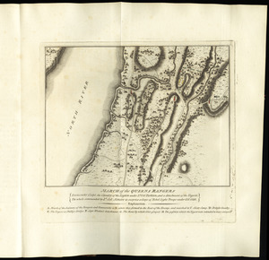
A map of the inhabited part of Canada from the French surveys : with the frontiers of New York and New England from the large...
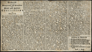
169.
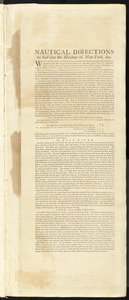
A map of the most inhabited part of New England : containing the provinces of Massachusets Bay and New Hampshire, with the...
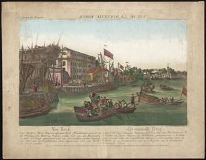
170.
A map of the most inhabited part of Virginia containing the whole province of Maryland with part of Pensilvania, New Jersey and...
171.
A map of the north west parts of the United States of America
172.
A map of the Province of New-York : reduc'd from the large drawing of that province, compiled from actual surveys by order of...
173.
[Map of the Siege of Mud Island Fort]
174.
A map of the United States of N. America
175.
Map of the western parts of the colony of Virginia, as far as the Mississipi
176.
March of the Queens Rangers : Emmericks Corps, the Cavalry of the Legion under Lt. Col. Tarleton, and a detachment of the...
177.
Nachricht von der belagerung und einnahme der stadt und hafens Charlestown in America
178.
Nautical directions to sail into the harbour of New-York, &c.
179.
Neu Yorck = : La Nouvelle Yorck
180.
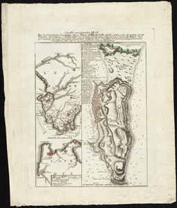
Neuester und acurater plan der weltberuhmten Englischen berg festung Gibraltar auf der Spitze von Spanien : derer wercher...
‹ Prev
Next ›
1
2
…
5
6
7
8
9
10
11
12
13
…
16
17
![[Map of Boston]](https://bpldcassets.blob.core.windows.net/derivatives/images/commonwealth:z603vw17n/image_thumbnail_300.jpg)
![[Map of Florida, Carolina, and the Gulf Coast]](https://bpldcassets.blob.core.windows.net/derivatives/images/commonwealth:z603vr379/image_thumbnail_300.jpg)

![[Map of the Allegheny and Ohio Rivers] ; Franzosische see kusten von Provence zwischen Marseille und Toulon =](https://bpldcassets.blob.core.windows.net/derivatives/images/commonwealth:z603vr31n/image_thumbnail_300.jpg)


![[Map of the Siege of Mud Island Fort]](https://bpldcassets.blob.core.windows.net/derivatives/images/commonwealth:z603vr43f/image_thumbnail_300.jpg)