Toggle navigation
LMEC Home
Exhibitions
Georeferencing
Tools for Teachers
Collections
My Favorites
Sign Up / Log In
Search
Search the map portal
Map Collection
Map Collection
Map Sets
Search
Search
Search for
Search In
All Fields
Creator
Title
Subject
Place
Search All Digital Collections
Advanced Search
318 Results
My Search
Start Over
More Like
commonwealth:z603vs367
Remove constraint More Like: commonwealth:z603vs367
Filter your Search
Place
North and Central America
251
United States
190
New York
31
Suffolk (county)
31
Boston
29
Canada
27
North America
27
North Carolina
26
more
Place
»
Topic
North Carolina--Maps--Early works to 1800
25
South Carolina--Maps--Early works to 1800
20
North America--Maps--Early works to 1800
18
Boston (Mass.)--History--Revolution, 1775-1783--Maps--Early works to 1800
16
Virginia--Maps--Early works to 1800
11
Vues d'optique
10
Gibraltar--History--Siege, 1779-1783--Maps--Early works to 1800
9
New York (N.Y.)--Pictorial works--Early works to 1800
9
more
Topic
»
Date
Date range begin
–
Date range end
Current results range from
1590
to
1816
View distribution
Creator
Faden, William, 1749-1836
33
Jefferys, Thomas, -1771
29
Le Rouge, Georges-Louis
23
Des Barres, Joseph F. W. (Joseph Frederick Wallet), 1722-1824
21
Sayer, Robert, 1725-1794
19
Korn, Christoph Heinrich, 1726-1783
11
Raspe, Gabriel Nicolaus, 1712-1785
11
Robert Sayer and John Bennett (Firm)
10
more
Creator
»
Format
Maps/Atlases
275
Prints
32
Manuscripts
23
Drawings/Illustrations
9
Books
2
Georeferenced
Yes
13
No
305
Collection
American Revolutionary War-Era Maps
304
Richard H. Brown Revolutionary War Map Collection at Mount Vernon
293
Norman B. Leventhal Map & Education Center Collection
16
MacLean Collection Map Library
8
Maritime Charts and Atlases
7
Boston and New England Maps
4
Urban Maps
2
New York Public Library Collection
1
Available to use
Creative Commons license
294
No known restrictions
16
Search Constraints
Sort by relevance
relevance
title
date (asc)
date (desc)
Number of results to display per page
20 per page
10
per page
20
per page
50
per page
100
per page
View results as:
grid view
map view
Search Results
1.
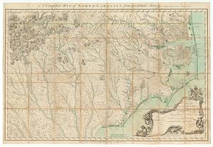
A compleat map of North Carolina from an actual survey
2.
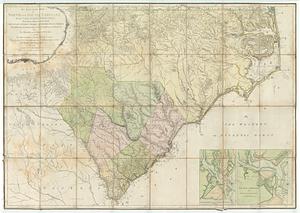
An accurate map of North and South Carolina with their Indian frontiers : shewing in a distinct manner all the mountains,...
3.
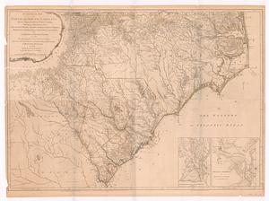
An accurate map of North and South Carolina with their Indian frontiers, shewing in a distinct manner all the mountains,...
4.
An accurate map of North and South Carolina with their Indian frontiers, shewing in a distinct manner all the mountains,...
5.
Americæ pars, nunc Virginia dicta, primum ab Anglis inuenta, sumtibus Dn. Walteri Raleigh, equestris ordinis Viri, Anno Dn̄i....
6.
Carolina
7.
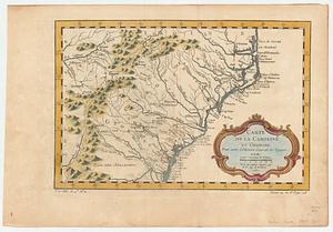
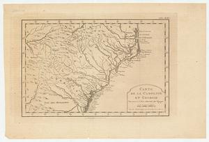
Carte de la Caroline et Georgie : pour servir à l'histoire générale des voyages
8.
Carte de la Caroline et Georgie : pour servir à l'histoire générale des voyages
9.
Carte des deux Carolines et de la Géorgie
10.
Chart of the coast of America from Cape Hateras to Cape Roman
11.
Chart of the coast of America from Cape Hateras to Cape Roman
12.
Chart of the coast of America from Cape Hateras to Cape Roman
13.
Chart of the coast of America from Cape Hateras to Cape Roman
14.
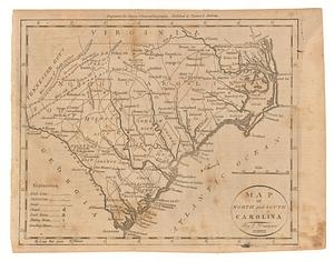
Map of North and South Carolina
15.
A map of the seat of war in the southern part of Virginia, North Carolina, and the northern part of South Carolina
16.
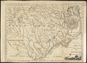
A new and accurate map of North Carolina in North America
17.
A New description of Carolina
18.
A new map of Carolina
19.
A new mapp of Carolina
20.
Partie meridionale des possessions angloise en Amerique
‹ Prev
Next ›
1
2
3
4
5
…
15
16