Toggle navigation
LMEC Home
Exhibitions
Georeferencing
Tools for Teachers
Collections
My Favorites
Sign Up / Log In
Search
Search the map portal
Map Collection
Map Collection
Map Sets
Search
Search
Search for
Search In
All Fields
Creator
Title
Subject
Place
Search All Digital Collections
Advanced Search
265 Results
My Search
Start Over
More Like
commonwealth:z603vm790
Remove constraint More Like: commonwealth:z603vm790
Filter your Search
Place
North and Central America
261
United States
237
New England
118
New York
81
Maine
52
New Hampshire
31
Massachusetts
27
Canada
24
more
Place
»
Topic
New England--Maps
120
New York (State)--Maps
81
Maine--Maps
50
Railroads--New England--Maps
50
New Hampshire--Maps
31
Railroads--New York (State)--Maps
21
Massachusetts--Maps
20
Vermont--Maps
15
more
Topic
»
Date
Date range begin
–
Date range end
Current results range from
1700
to
2015
View distribution
Creator
United States. Post Office Dept
12
Carleton, Osgood, 1742-1816
7
Carey, Mathew, 1760-1839
6
Holland, Samuel, 1728-1801
5
Lewis, Samuel, 1753 or 4-1822
5
Geological Survey (U.S.)
4
National Publishing Company (Boston, Mass.)
4
Norman, John, 1748?-1817
4
more
Creator
»
Format
Maps/Atlases
265
Manuscripts
6
Objects/Artifacts
1
Georeferenced
Yes
29
No
236
Collection
Norman B. Leventhal Map & Education Center Collection
183
Boston and New England Maps
115
American Revolutionary War-Era Maps
78
William L. Clements Library Collection
33
American Antiquarian Society Collection
26
Massachusetts Historical Society Map Collection
14
David Judkins Weaver Papers
4
Sidney R. Knafel Map Collection at Phillips Academy
4
more
Collection
»
Available to use
No known restrictions
184
Creative Commons license
16
Search Constraints
Sort by relevance
relevance
title
date (asc)
date (desc)
Number of results to display per page
20 per page
10
per page
20
per page
50
per page
100
per page
View results as:
grid view
map view
Search Results
81.
A plan of a rout from Fort Pownall on the river Penobscot in New England to Quebec and from Quebec to Fort Pownall : taken by...
82.
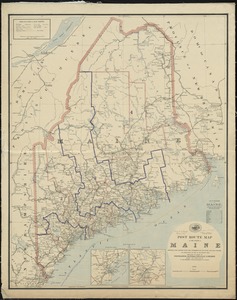
Post route map of the State of Maine showing post offices with the intermediate distances and mail routes in operation on the...
83.
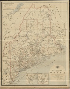
Post route map of the State of Maine showing post offices with the intermediate distances and mail routes in operation on the...
84.
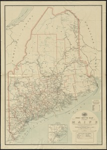
Post route map of the state of Maine showing post offices with the intermediate distances on mail routes in operation on the...
85.
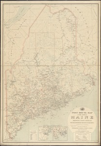
Post route map of the state of Maine showing post offices with the intermediate distances on mail routes in operation on the...
86.
Province of Maine
87.
The province of Maine, from the best authorities
88.
The Province of Maine, from the best authorities 1795
89.
Route and pictorial map of Maine
90.
State of Maine
91.
State of Maine
92.
State of Maine
93.
This plan represents par of the Bay of Passamoquoddy : the rivers Scoodic and Passamaquoddy which empty into said bay being an...
94.
This plan represents within the red lines twenty two townships of land situate between the million acres located on the River...
95.
15 lots of 440a each in Great Lot no. 4 of Macomb purchase : 6600 acres within 2 miles of the St. Lawrence Turnpike & 1/2 mile...
96.
1st. sheet of De Witt's state-map of New York
97.
An accurate map of New York in North America from a late survey
98.
Connecticut with portions of New York & Rhode Island
99.
Four wood lots in no 3
100.
Fragment of map showing two small fortifications
‹ Prev
Next ›
1
2
3
4
5
6
7
8
9
…
13
14