Toggle navigation
LMEC Home
Exhibitions
Georeferencing
Tools for Teachers
Collections
My Favorites
Sign Up / Log In
Search
Search the map portal
Map Collection
Map Collection
Map Sets
Search
Search
Search for
Search In
All Fields
Creator
Title
Subject
Place
Search All Digital Collections
Advanced Search
75 Results
My Search
Start Over
More Like
commonwealth:z603vh67k
Remove constraint More Like: commonwealth:z603vh67k
Filter your Search
Place
United States
51
North and Central America
48
Gibraltar
10
Charleston (county)
8
North America
8
Boston
7
Canada
7
Suffolk (county)
7
more
Place
»
Topic
United States--History--Revolution, 1775-1783--Maps--Early works to 1800
36
Gibraltar--History--Siege, 1779-1783--Maps--Early works to 1800
10
Gibraltar--History--Revolution, 1775-1783--Maps--Early works to 1800
6
North America--History--Revolution, 1775-1783--Maps--Early works to 1800
6
Yorktown (Va.)--History--Siege, 1781--Maps--Early works to 1800
6
New England--Maps--Early works to 1800
5
United States--Maps--Early works to 1800
5
Antilles, Greater--Maps--Early works to 1800
4
more
Topic
»
Date
Date range begin
–
Date range end
Current results range from
1775
to
1795
View distribution
Creator
Faden, William, 1749-1836
12
Aitken, Robert, 1735-1802
6
Conder, Thomas, 1746 or 1747-1831
5
Bonne, Rigobert, 1727-1794
4
Brion de la Tour, Louis
3
Des Barres, Joseph F. W. (Joseph Frederick Wallet), 1722-1824
3
Lattré, Jean
3
Robert Sayer and John Bennett (Firm)
3
more
Creator
»
Format
Maps/Atlases
64
Books
7
Prints
4
Manuscripts
3
Georeferenced
Yes
1
No
74
Collection
American Revolutionary War-Era Maps
74
Harvard Map Collection
31
Norman B. Leventhal Map & Education Center Collection
17
Richard H. Brown Revolutionary War Map Collection at Mount Vernon
17
Boston and New England Maps
4
New York Public Library Collection
3
New-York Historical Society Collection
3
Boston Athenaeum, Cartographic Collection
2
more
Collection
»
Available to use
Creative Commons license
53
No known restrictions
20
Search Constraints
Sort by date (asc)
relevance
title
date (asc)
date (desc)
Number of results to display per page
20 per page
10
per page
20
per page
50
per page
100
per page
View results as:
grid view
map view
Search Results
41.
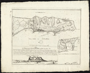
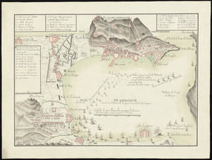
Plan der belagerung der stadt Gibraltar im jahr 1779, 1780, 1781
42.
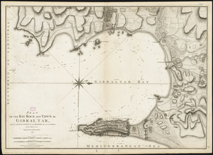
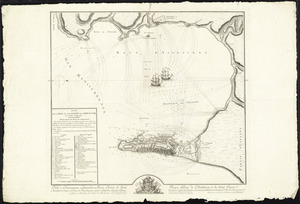
Plan of the bay, rock and town of Gibraltar, from an actual survey by an officer who was at Gibraltar from 1769 to 1775
43.
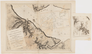
A plan of the posts of York and Gloucester in the province of Virginia, established by His Majesty's army under the command of...
44.
Plan of the town of Boston, with the attack on Bunkers-Hill, in the peninsula of Charlestown, the 17th of June, 1775
45.
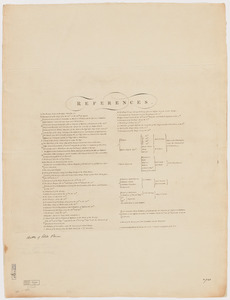
References to charts of the coast and harbors of New England
46.
Théatre de la guerre en Amerique, avec les Isles Antilles : projetté et assujettie aux observations
47.
Théatre de la guerre en Amerique, avec les Isles Antilles : projetté et assujettie aux observations
48.
Théatre de la guerre en Amerique, avec les Isles Antilles : projetté et assujettie aux observations
49.
Abriss der stadt Gibraltar und der darinn befindlichen festen platze, nebst dem meerbusen von Algesiras
50.
Plan de Gibraltar
51.
Plan de la ville et des forts de Gibraltar, avec la Baye d'Algesiras
52.
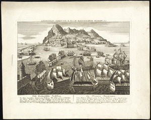
La premiere representation de les X batteries flottantes
53.
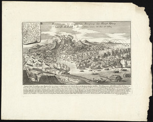
Prospect von Gibraltar mit seinen werken, umliegenden gegenden und iezigen neuern belagerungs anstalten : gezeichnet vor...
54.
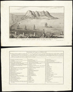
Relation von der vergeblichen belagrung der haupt vestung Gibraltar : anno 1782 von 13 bis 17 sbre
55.
Suite du theatre de la guerre dans l'Amérique Septentrionale y compris le Golfe du Méxique
56.
Carte des Etats-Unis d'Amérique, et du cours du Mississippi : rédigée d'après différentes cartes et relations Anglaises et...
57.
Carte generale des colonies angloises dans l'Amerique Septentrionale pour l'intelligence de la guerre presente : d'apres des...
58.
Carte generale des colonies angloises dans l'Amerique Septentrionale pour l'intelligence de la guerre presente : d'apres des...
59.
The United States of North America, with the British & Spanish territories according to the treaty
60.
Carte des Etats-Unis de l'Amerique suivant le Traité de Paix de 1783
‹ Prev
Next ›
1
2
3
4