Toggle navigation
LMEC Home
Exhibitions
Georeferencing
Tools for Teachers
Collections
My Favorites
Sign Up / Log In
Search
Search the map portal
Map Collection
Map Collection
Map Sets
Search
Search
Search for
Search In
All Fields
Creator
Title
Subject
Place
Search All Digital Collections
Advanced Search
393 Results
My Search
Start Over
More Like
commonwealth:z603vh359
Remove constraint More Like: commonwealth:z603vh359
Filter your Search
Place
North and Central America
359
United States
289
Massachusetts
253
Suffolk (county)
53
Boston
52
Rhode Island
33
Canada
23
Connecticut
23
more
Place
»
Topic
Massachusetts--Maps
235
Boston (Mass.)--Maps
55
Rhode Island--Maps
34
Railroads--Massachusetts--Maps
31
Connecticut--Maps
24
New England--Maps
22
United States--Maps
21
Roads--Massachusetts--Maps
19
more
Topic
»
Date
Date range begin
–
Date range end
Current results range from
1750
to
2020
View distribution
Creator
MassGIS (Office : Mass.)
20
Geo. H. Walker & Co
18
Massachusetts. Executive Office of Environmental Affairs
14
Carleton, Osgood, 1742-1816
12
Reid, John, 1764?-1828
12
Boston Public Library. Norman B. Leventhal Map and Education Center
9
Farwell, John Whittemore, 1843-1929
9
Kitchin, Thomas, 1719-1784
9
more
Creator
»
Format
Maps/Atlases
391
Manuscripts
12
Books
4
Ephemera
1
Prints
1
Georeferenced
Yes
75
No
318
Collection
Norman B. Leventhal Map & Education Center Collection
223
Boston and New England Maps
186
American Revolutionary War-Era Maps
153
American Antiquarian Society Collection
138
Applied Geographics, Inc. Records
20
David Judkins Weaver Papers
19
Urban Maps
19
Massachusetts Real Estate Atlases
8
more
Collection
»
Available to use
No known restrictions
215
Creative Commons license
13
Search Constraints
Sort by relevance
relevance
title
date (asc)
date (desc)
Number of results to display per page
20 per page
10
per page
20
per page
50
per page
100
per page
View results as:
grid view
map view
Search Results
21.
Map of the county of Berkshire, Massachusetts : based upon the trigonometrical survey of the state
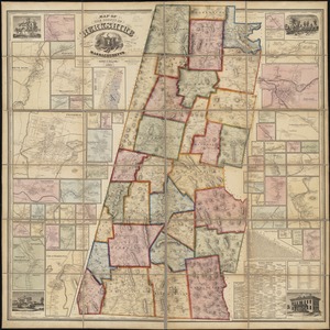
22.
County atlas of Hampshire, Massachusetts
23.
County atlas of Hampshire, Massachusetts : from actual surveys
24.
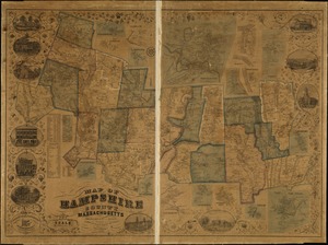
Map of Hampshire County, Massachusetts
25.
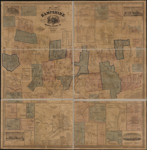
Map of the county of Hampshire, Massachusetts : based upon the trigonometrical survey of the state
26.
Massachusetts
27.
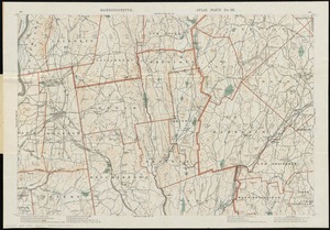
A topographical map of Hampshire County Massachusetts : based upon the trigonometrical survey of the state
28.
The 100th anniversary map of Abraham Lincoln's visit to Massachusetts, September 11-23, 1848
29.
An accurate map of the commonwealth of Massachusetts exclusive of the district of Maine compiled pursuant to an act of the...
30.
An accurate map of the commonwealth of Massachusetts exclusive of the district of Maine compiled pursuant to an act of the...
31.
Annexation map
32.
Atlas of Massachusetts
33.
Automobile map of Massachusetts : central section
34.
Bicycle map of Massachusetts
35.
Bicycle map of north eastern Massachusetts
36.
Bicycle map of south eastern Massachusetts
37.
Bicycle map of western Massachusetts
38.
Boston & Gloucester Steamboat Co. : summer season 1889
39.
Boston and its suburban drives
40.
[Boston and Northwestern Junction Railroad]
‹ Prev
Next ›
1
2
3
4
5
6
…
19
20


![[Boston and Northwestern Junction Railroad]](https://bpldcassets.blob.core.windows.net/derivatives/images/commonwealth:x059cc74n/image_thumbnail_300.jpg)