Toggle navigation
LMEC Home
Exhibitions
Georeferencing
Tools for Teachers
Collections
My Favorites
Sign Up / Log In
Search
Search the map portal
Map Collection
Map Collection
Map Sets
Search
Search
Search for
Search In
All Fields
Creator
Title
Subject
Place
Search All Digital Collections
Advanced Search
8703 Results
My Search
Start Over
More Like
commonwealth:x059cc481
Remove constraint More Like: commonwealth:x059cc481
Filter your Search
Place
North and Central America
5,934
United States
4,850
Massachusetts
2,082
Europe
1,396
Suffolk (county)
1,046
Boston
1,019
Canada
449
Asia
438
more
Place
»
Topic
Boston (Mass.)--Maps
588
United States--Maps
282
Real property--Massachusetts--Boston--Maps
175
Massachusetts--Maps
164
Landowners--Massachusetts--Boston--Maps
133
North America--Maps--Early works to 1800
103
New England--Maps
102
Europe--Maps
79
more
Topic
»
Date
Date range begin
–
Date range end
Current results range from
1482
to
2023
View distribution
Creator
United States. Hydrographic Office
595
O.H. Bailey & Co
148
Des Barres, Joseph F. W. (Joseph Frederick Wallet), 1722-1824
123
United States. Post Office Dept
120
Ptolemy, 2nd cent
100
Walling, Henry Francis, 1825-1888
94
Geological Survey (U.S.)
87
Jefferys, Thomas, -1771
85
more
Creator
»
Format
Maps/Atlases
8,643
Manuscripts
217
Prints
56
Books
36
Objects/Artifacts
10
Drawings/Illustrations
8
Posters
5
Georeferenced
Yes
869
No
7,834
Collection
Norman B. Leventhal Map & Education Center Collection
8,694
Boston and New England Maps
2,232
Urban Maps
2,022
Maritime Charts and Atlases
1,083
American Revolutionary War-Era Maps
618
Boston Redevelopment Authority Collection
87
Massachusetts Real Estate Atlases
7
Maps from AAS
2
Available to use
No known restrictions
8,552
Creative Commons license
47
Search Constraints
Sort by relevance
relevance
title
date (asc)
date (desc)
Number of results to display per page
20 per page
10
per page
20
per page
50
per page
100
per page
View results as:
grid view
map view
Search Results
8281.
View of Attleborough, Mass : East Village, 1878
8282.
View of Bethel, Conn
8283.
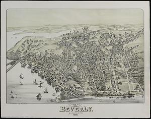
View of Beverly, Mass
8284.
View of Beverly, Massachusetts, 1886
8285.
A view of Boston
8286.
View of Boston freight terminals, the New York, New Haven & Hartford Railroad
8287.
View of Boston, July 4th 1870
8288.
A view of Boston taken on the road to Dorchester
8289.
View of Bristol, Conn
8290.
View of Canton, Mass : 1878
8291.
View of Cape Egmont and winter Rock from the eastward : Entrance of Egmont Harbor ; The entrance of Keppel Harbor, 10 leagues...
8292.
View of Chatham : New Brunswick
8293.
View of Cheshire, Connecticut : 1882
8294.
View of Chester, Connecticut : 1881
8295.
View of Clinton, Connecticut : 1881
8296.
View of College Point, L.I : 1876
8297.
View of Collinsville, Conn : 1878
8298.
View of Danbury, Conn : 1875
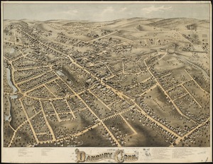
8299.
View of Dedham, Mass. in 1876
8300.
View of East Boston, Mass : 1879
‹ Prev
Next ›
1
2
…
411
412
413
414
415
416
417
418
419
…
435
436