Toggle navigation
LMEC Home
Exhibitions
Georeferencing
Tools for Teachers
Collections
My Favorites
Sign Up / Log In
Search
Search the map portal
Map Collection
Map Collection
Map Sets
Search
Search
Search for
Search In
All Fields
Creator
Title
Subject
Place
Search All Digital Collections
Advanced Search
8878 Results
My Search
Start Over
More Like
commonwealth:wd376217m
Remove constraint More Like: commonwealth:wd376217m
Filter your Search
Place
North and Central America
6,109
United States
5,025
Massachusetts
2,147
Europe
1,396
Suffolk (county)
1,214
Boston
1,187
Canada
449
Asia
438
more
Place
»
Topic
Boston (Mass.)--Maps
752
United States--Maps
282
Real property--Massachusetts--Boston--Maps
195
Massachusetts--Maps
166
City planning--Massachusetts--Boston--Maps
160
Landowners--Massachusetts--Boston--Maps
142
New England--Maps
104
North America--Maps--Early works to 1800
103
more
Topic
»
Date
Date range begin
–
Date range end
Current results range from
1482
to
2023
View distribution
Creator
United States. Hydrographic Office
595
Boston Redevelopment Authority
164
O.H. Bailey & Co
148
Des Barres, Joseph F. W. (Joseph Frederick Wallet), 1722-1824
124
United States. Post Office Dept
120
Ptolemy, 2nd cent
100
Walling, Henry Francis, 1825-1888
94
Geological Survey (U.S.)
87
more
Creator
»
Format
Maps/Atlases
8,818
Manuscripts
215
Prints
56
Books
36
Objects/Artifacts
10
Drawings/Illustrations
8
Posters
6
Georeferenced
Yes
885
No
7,993
Collection
Norman B. Leventhal Map & Education Center Collection
8,731
Boston and New England Maps
2,368
Urban Maps
2,144
Maritime Charts and Atlases
1,087
American Revolutionary War-Era Maps
644
Boston Redevelopment Authority Collection
194
Mapping Boston Collection
27
William L. Clements Library Collection
15
more
Collection
»
Available to use
No known restrictions
8,668
Creative Commons license
78
Search Constraints
Sort by relevance
relevance
title
date (asc)
date (desc)
Number of results to display per page
20 per page
10
per page
20
per page
50
per page
100
per page
View results as:
grid view
map view
Search Results
3301.
Hawaiian or Sandwich Islands
3302.
Haydenville, Mass : 1886
3303.
Hazleton : Pennsylvania
3304.
Head of Green Bay and entrance to Fox River, Wisconsin : from surveys under the direction of the Bureau of Topographical...
3305.
The health and pleasure resorts of New York and New England, the best way to reach them via "America's greatest railroad" : the...
3306.
Health crisis : Massachusetts' low income families more likely to live near hazardous sites
3307.
Health success : Massachusetts well-prepared to deal with health issues from hazardous sites
3308.
The heart of New England
3309.
Heathcote Farm
3310.
Heathers, improved chart of the Bermudas, drawn from the best surveys
3311.
Heather's New and Improved Chart of the Isles of Scilly
3312.
Helvetien nach den zuverlässigsten astronomischen Bestim̄ungen, aus den charten von Weisse, Bacler d'Albe, Mallet, Feer, und...
3313.
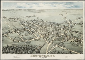
Hempstead, N.Y : Long Island, 1876
3314.
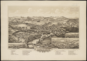
Henniker, N.H
3315.
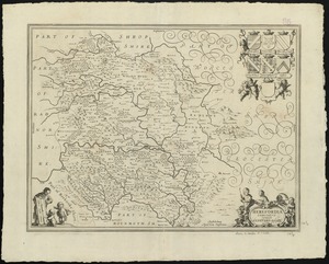
Herefordia comitatus vernacule Hereford Shire
3316.
Hereheretue or St. Pablo, Paumotu Group ; Nukutipipi or Margaret Island, Paumotu Group ; Anu-Anuraro, Heretua or Archangel of...
3317.
[Het ko]ningrijk [d]er Nederlanden
3318.
A hexagonal chart of yearly snowfall in New England up through and including November 1, 2020
3319.
H.H. Lloyd & Co's campaign military charts showing the principal strategic places of interest
3320.
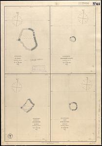
Hibernia mine tract : with profile & section showing working's Sept. 1855
‹ Prev
Next ›
1
2
…
162
163
164
165
166
167
168
169
170
…
443
444


![[Het ko]ningrijk [d]er Nederlanden](https://bpldcassets.blob.core.windows.net/derivatives/images/commonwealth:0z709589n/image_thumbnail_300.jpg)