Toggle navigation
LMEC Home
Exhibitions
Georeferencing
Tools for Teachers
Collections
My Favorites
Sign Up / Log In
Search
Search the map portal
Map Collection
Map Collection
Map Sets
Search
Search
Search for
Search In
All Fields
Creator
Title
Subject
Place
Search All Digital Collections
Advanced Search
8754 Results
My Search
Start Over
More Like
commonwealth:wd376176k
Remove constraint More Like: commonwealth:wd376176k
Filter your Search
Place
North and Central America
5,985
United States
4,878
Massachusetts
2,079
Europe
1,396
Suffolk (county)
1,046
Boston
1,019
Canada
450
Asia
438
more
Place
»
Topic
Boston (Mass.)--Maps
586
United States--Maps
282
Real property--Massachusetts--Boston--Maps
175
Massachusetts--Maps
162
Landowners--Massachusetts--Boston--Maps
133
North America--Maps--Early works to 1800
105
New England--Maps
102
Europe--Maps
79
more
Topic
»
Date
Date range begin
–
Date range end
Current results range from
1482
to
2023
View distribution
Creator
United States. Hydrographic Office
595
O.H. Bailey & Co
148
Des Barres, Joseph F. W. (Joseph Frederick Wallet), 1722-1824
123
United States. Post Office Dept
120
Ptolemy, 2nd cent
100
Walling, Henry Francis, 1825-1888
94
Jefferys, Thomas, -1771
91
Geological Survey (U.S.)
86
more
Creator
»
Format
Maps/Atlases
8,694
Manuscripts
218
Prints
56
Books
36
Objects/Artifacts
10
Drawings/Illustrations
8
Posters
5
Georeferenced
Yes
874
No
7,880
Collection
Norman B. Leventhal Map & Education Center Collection
8,695
Boston and New England Maps
2,233
Urban Maps
2,023
Maritime Charts and Atlases
1,083
American Revolutionary War-Era Maps
674
Boston Redevelopment Authority Collection
87
MacLean Collection Map Library
20
New York Public Library Collection
18
more
Collection
»
Available to use
No known restrictions
8,554
Creative Commons license
81
Search Constraints
Sort by relevance
relevance
title
date (asc)
date (desc)
Number of results to display per page
20 per page
10
per page
20
per page
50
per page
100
per page
View results as:
grid view
map view
Search Results
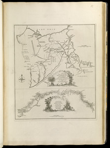
41.
A map of the country on the Ohio and Muskingum Rivers : shewing the situation of the Indian towns with respect to the army...
42.
A mapp of ye improved part of Pensilvania in America, divided into countyes, townships, and lotts
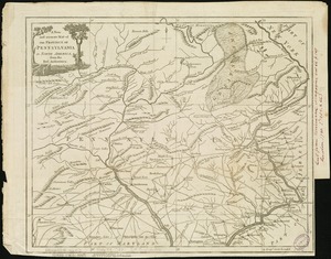
43.
A new and accurate map of the province of Pennsylvania in North America, from the best authorities
44.
A plan of the city and environs of Philadelphia
45.
The State of Pennsylvania
46.
To the Honourable Thomas Penn and Richard Penn, Esqrs., true & absolute proprietaries & Governours of the Province of...
47.
Americæ pars, nunc Virginia dicta, primum ab Anglis inuenta, sumtibus Dn. Walteri Raleigh, equestris ordinis Viri, Anno Dn̄i....
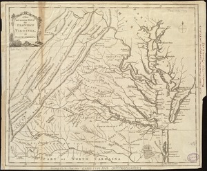
48.
A new and accurate map of the province of Virginia in North America
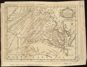
49.
A new map of Virginia from the best authorities
50.
Virginia
51.
Virginia, Maryland, Pennsilvania, east & west New Jarsey
52.
Virginiae item et Floridae Americae provincarum, nova descriptio
53.
Virginiae item et Floridae Americae provinciarum, nova descriptio
54.
Virginiae partis australis, et Floridae partis orientalis, interjacentiumq[ue] regionum nova descriptio
55.
Virginiae partis australis et Floridae partis orientalis, interjacentium[que] regionum nova descriptio
56.
A map of Maryland with the Delaware counties and the southern part of New Jersey &c
57.
An accurate map of Staten Island : with that part of New York, Long Island and the Jerseys, which is the rendesvous of the two...
58.
A map of the eastern part of the province of New York with part of New Jersey, & c
59.
A map of the eastern part of the province of New York with part of New Jersey, & c
60.
Mappa geographica Provinciæ Nova Eboraci ab Anglis New-York : dictæ ex ampliori delineatione ad exactas dimensiones concinnata...
‹ Prev
Next ›
1
2
3
4
5
6
7
…
437
438


![Virginiae partis australis, et Floridae partis orientalis, interjacentiumq[ue] regionum nova descriptio](https://bpldcassets.blob.core.windows.net/derivatives/images/commonwealth:st74cw930/image_thumbnail_300.jpg)
![Virginiae partis australis et Floridae partis orientalis, interjacentium[que] regionum nova descriptio](https://bpldcassets.blob.core.windows.net/derivatives/images/commonwealth:6t053p120/image_thumbnail_300.jpg)


