Toggle navigation
LMEC Home
Exhibitions
Georeferencing
Tools for Teachers
Collections
My Favorites
Sign Up / Log In
Search
Search the map portal
Map Collection
Map Collection
Map Sets
Search
Search
Search for
Search In
All Fields
Creator
Title
Subject
Place
Search All Digital Collections
Advanced Search
8941 Results
My Search
Start Over
More Like
commonwealth:w9505s72w
Remove constraint More Like: commonwealth:w9505s72w
Filter your Search
Place
North and Central America
6,092
United States
4,936
Massachusetts
2,079
Europe
1,396
Suffolk (county)
1,046
Boston
1,019
Canada
503
Asia
441
more
Place
»
Topic
Boston (Mass.)--Maps
586
United States--Maps
282
North America--Maps--Early works to 1800
240
Real property--Massachusetts--Boston--Maps
175
Massachusetts--Maps
162
Landowners--Massachusetts--Boston--Maps
133
United States--Maps--Early works to 1800
103
New England--Maps
102
more
Topic
»
Date
Date range begin
–
Date range end
Current results range from
1482
to
2023
View distribution
Creator
United States. Hydrographic Office
595
O.H. Bailey & Co
148
Des Barres, Joseph F. W. (Joseph Frederick Wallet), 1722-1824
123
United States. Post Office Dept
120
Ptolemy, 2nd cent
100
Jefferys, Thomas, -1771
95
Walling, Henry Francis, 1825-1888
94
Sayer, Robert, 1725-1794
87
more
Creator
»
Format
Maps/Atlases
8,881
Manuscripts
219
Prints
56
Books
36
Objects/Artifacts
10
Drawings/Illustrations
8
Posters
5
Georeferenced
Yes
874
No
8,067
Collection
Norman B. Leventhal Map & Education Center Collection
8,706
Boston and New England Maps
2,234
Urban Maps
2,023
Maritime Charts and Atlases
1,083
American Revolutionary War-Era Maps
845
MacLean Collection Map Library
126
Boston Redevelopment Authority Collection
87
New York Public Library Collection
46
more
Collection
»
Available to use
No known restrictions
8,558
Creative Commons license
140
Search Constraints
Sort by relevance
relevance
title
date (asc)
date (desc)
Number of results to display per page
20 per page
10
per page
20
per page
50
per page
100
per page
View results as:
grid view
map view
Search Results
2321.
Diversi globi terr-aquei statione variante et visu intercedente, per coluros tropicorum, per ambos polos et particul : sphaerae...
2322.
Dobroudja Campaigne, Oct. 1916 : Volhynie Campaigne, Oct. 1916 ; Izonzo Campaigne, Oct. 1916
2323.
Dodge County, Wis.
2324.
Dodgeville, Massachusetts
2325.
Dominia anglorum in præcipuis insulis Americæ ut sunt insula : S. Christophori, Antegoa, Iamaica, Barbados : nec non insulae...
2326.
Dominica
2327.
Dominica from an actual survey compleated in the year 1773
2328.
Dominican Republic road map 1:250,000
2329.
Dominio Fiorentino
2330.
Dominion of Canada
2331.
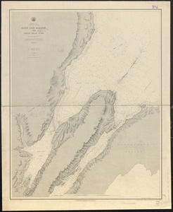
Dominion of Canada, Cape Breton Island, Saint Anne Harbor and Great Bras d'Or : from British surveys in 1848-57
2332.
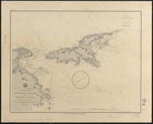
Dominion of Canada, Cape Breton Island, Scatari Island and Menadou Passage : from a British survey in 1850
2333.
Dominion of Canada, Cape Breton Island, Sydney Harbor : from a British survey in 1849
2334.
The Dominion of Canada from the latest surveys and data
2335.
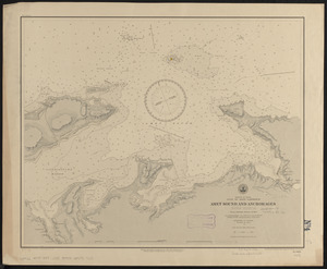
Dominion of Canada, Gulf of Saint Lawrence, Amet Sound and anchorages (Nova Scotia) : from a British survey in 1841
2336.
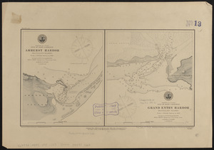
Dominion of Canada, Gulf of Saint Lawrence, Amherst Harbor (Magdalen Islands) : from a British survey in 1833 ; Dominion of...
2337.
Dominion of Canada, Gulf of Saint Lawrence, Merigomish Harbor (Nova Scotia) : from a British survey in 1842
2338.
Dominion of Canada, Gulf of Saint Lawrence, Port Hood (Cape Breton Island) : from British surveys in 1847 & 1873
2339.
Dominion of Canada, Gulf of Saint Lawrence, Shediac Bay and Harbor (New Brunswick) : from a British survey in 1885
2340.
Dominion of Canada, Gulf of St. Lawrence, Cardigan Bay (Prince Edward Island) : from a British survey in 1844
‹ Prev
Next ›
1
2
…
113
114
115
116
117
118
119
120
121
…
447
448