Toggle navigation
LMEC Home
Exhibitions
Georeferencing
Tools for Teachers
Collections
My Favorites
Sign Up / Log In
Search
Search the map portal
Map Collection
Map Collection
Map Sets
Search
Search
Search for
Search In
All Fields
Creator
Title
Subject
Place
Search All Digital Collections
Advanced Search
8812 Results
My Search
Start Over
More Like
commonwealth:w3765q66z
Remove constraint More Like: commonwealth:w3765q66z
Filter your Search
Place
North and Central America
6,051
United States
4,968
Massachusetts
2,115
Europe
1,392
Suffolk (county)
1,201
Boston
1,174
Canada
449
Asia
437
more
Place
»
Topic
Boston (Mass.)--Maps
747
United States--Maps
279
Real property--Massachusetts--Boston--Maps
195
Massachusetts--Maps
165
City planning--Massachusetts--Boston--Maps
156
Landowners--Massachusetts--Boston--Maps
142
New England--Maps
103
North America--Maps--Early works to 1800
103
more
Topic
»
Date
Date range begin
–
Date range end
Current results range from
1482
to
2023
View distribution
Creator
United States. Hydrographic Office
595
Boston Redevelopment Authority
162
O.H. Bailey & Co
148
Des Barres, Joseph F. W. (Joseph Frederick Wallet), 1722-1824
124
United States. Post Office Dept
120
Ptolemy, 2nd cent
100
Walling, Henry Francis, 1825-1888
94
Geological Survey (U.S.)
87
more
Creator
»
Format
Maps/Atlases
8,752
Manuscripts
215
Prints
56
Books
36
Objects/Artifacts
10
Drawings/Illustrations
8
Posters
5
Georeferenced
Yes
885
No
7,927
Collection
Norman B. Leventhal Map & Education Center Collection
8,674
Boston and New England Maps
2,344
Urban Maps
2,111
Maritime Charts and Atlases
1,083
American Revolutionary War-Era Maps
637
Boston Redevelopment Authority Collection
191
Mapping Boston Collection
20
Massachusetts Real Estate Atlases
12
more
Collection
»
Available to use
No known restrictions
8,615
Creative Commons license
70
Search Constraints
Sort by relevance
relevance
title
date (asc)
date (desc)
Number of results to display per page
20 per page
10
per page
20
per page
50
per page
100
per page
View results as:
grid view
map view
Search Results
8501.
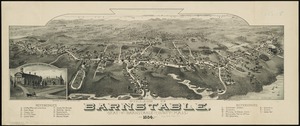
Village of Barnstable, seat of Barnstable County, Mass : 1884
8502.
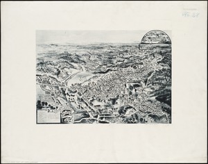
Village of Kingston, Plymouth County, Mass : 1885
8503.
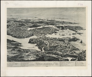
Vinalhaven, Me : 1893
8504.
Vineyard Haven, Dukes County, Martha's Vineyard, Massachusetts : the popular seaside summer resort
8505.
Vineyard Sound and Buzzards Bay, Massachusetts
8506.
Virginia
8507.
Virginia
8508.
Virginia
8509.
Virginia and Maryland
8510.
Virginia, Maryland, Pennsilvania, east & west New Jarsey
8511.
Virginia Marylandia et Carolina in America septentrionali Brittannorum industria excultæ
8512.
Virginiae item et Floridae Americae provincarum, nova descriptio
8513.
Virginiae item et Floridae Americae provinciarum, nova descriptio
8514.
Virginiae partis australis, et Floridae partis orientalis, interjacentiumq[ue] regionum nova descriptio
8515.
Virginiae partis australis et Floridae partis orientalis, interjacentium[que] regionum nova descriptio
8516.
A vision of Private Kutschkes of the German National Guard = Traumgebild des deutschen Landwehrmanns Kutschke!
8517.
Vltoniae orientalis : pars
8518.
Vmbria overo ducato di Spoleto
8519.
Völker und sprachen-karte von Deutschland und den nachbarländern im j. 1867
8520.
Volunteer militia and eastern army guide : One hundred and fifty miles around Richmond
‹ Prev
Next ›
1
2
…
422
423
424
425
426
427
428
429
430
…
440
441


![Virginiae partis australis, et Floridae partis orientalis, interjacentiumq[ue] regionum nova descriptio](https://bpldcassets.blob.core.windows.net/derivatives/images/commonwealth:st74cw930/image_thumbnail_300.jpg)
![Virginiae partis australis et Floridae partis orientalis, interjacentium[que] regionum nova descriptio](https://bpldcassets.blob.core.windows.net/derivatives/images/commonwealth:6t053p120/image_thumbnail_300.jpg)


