Toggle navigation
LMEC Home
Exhibitions
Georeferencing
Tools for Teachers
Collections
My Favorites
Sign Up / Log In
Search
Search the map portal
Map Collection
Map Collection
Map Sets
Search
Search
Search for
Search In
All Fields
Creator
Title
Subject
Place
Search All Digital Collections
Advanced Search
388 Results
My Search
Start Over
More Like
commonwealth:tx31x300d
Remove constraint More Like: commonwealth:tx31x300d
Filter your Search
Place
North and Central America
339
United States
213
North America
68
Canada
59
New York
24
Pennsylvania
18
Asia
17
New Hampshire
14
more
Place
»
Topic
North America--Maps--Early works to 1800
59
United States--Maps--Early works to 1800
43
Canada--Maps--Early works to 1800
38
New Hampshire--Maps--Early works to 1800
13
Great Lakes Region (North America)--Maps--Early works to 1800
12
Pennsylvania--Maps--Early works to 1800
11
New York (State)--Maps--Early works to 1800
9
Northeastern States--Maps--Early works to 1800
9
more
Topic
»
Date
Date range begin
–
Date range end
Current results range from
1623
to
1999
View distribution
Creator
Jefferys, Thomas, -1771
18
Bellin, Jacques Nicolas, 1703-1772
15
Gibson, J. (John), active 1750-1792
14
Robert Sayer and John Bennett (Firm)
14
Carleton, Osgood, 1742-1816
13
Faden, William, 1749-1836
13
Bowles, Carington, 1724-1793
10
Carey, Mathew, 1760-1839
10
more
Creator
»
Format
Maps/Atlases
386
Manuscripts
3
Paintings
3
Ephemera
1
Objects/Artifacts
1
Prints
1
Georeferenced
No
388
Collection
MacLean Collection Map Library
379
American Revolutionary War-Era Maps
336
Boston and New England Maps
7
Norman B. Leventhal Map & Education Center Collection
4
British Library Collection
3
Richard H. Brown Revolutionary War Map Collection at Mount Vernon
1
Sidney R. Knafel Map Collection at Phillips Academy
1
Available to use
Creative Commons license
4
No known restrictions
4
Search Constraints
Sort by relevance
relevance
title
date (asc)
date (desc)
Number of results to display per page
20 per page
10
per page
20
per page
50
per page
100
per page
View results as:
grid view
map view
Search Results
381.
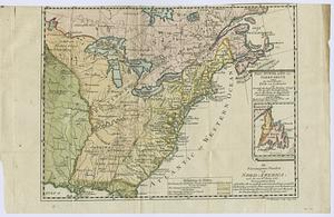
Die Vereinigten Staaten von Nord=America
382.
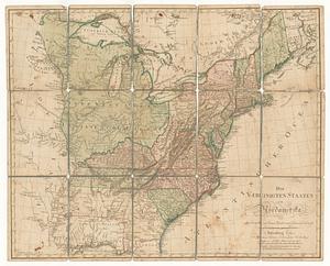
Die vereinigten staaten von Nordamerika
383.
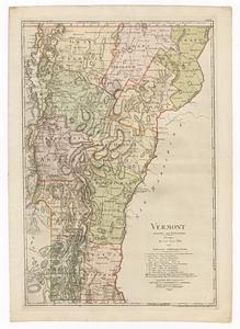
Vermont
384.
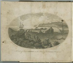
A view of Fort Oswego, on the shore of L. Ontario. lat 43°, 23', 05"
385.
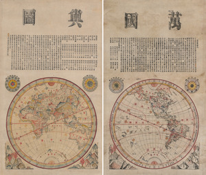
Wanguo yutu
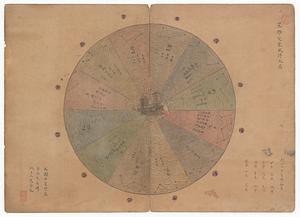
386.
Xingye dingxiang fang yangzhitu
387.
Yeojido
388.
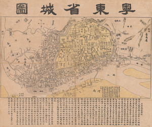
Yuedong sheng chengtu
‹ Prev
Next ›
1
2
…
16
17
18
19
20