Toggle navigation
LMEC Home
Exhibitions
Georeferencing
Tools for Teachers
Collections
My Favorites
Sign Up / Log In
Search
Search the map portal
Map Collection
Map Collection
Map Sets
Search
Search
Search for
Search In
All Fields
Creator
Title
Subject
Place
Search All Digital Collections
Advanced Search
8706 Results
My Search
Start Over
More Like
commonwealth:tt44pw59z
Remove constraint More Like: commonwealth:tt44pw59z
Filter your Search
Place
North and Central America
5,937
United States
4,854
Massachusetts
2,084
Europe
1,396
Suffolk (county)
1,047
Boston
1,020
Canada
449
Asia
438
more
Place
»
Topic
Boston (Mass.)--Maps
587
United States--Maps
282
Real property--Massachusetts--Boston--Maps
175
Massachusetts--Maps
163
Landowners--Massachusetts--Boston--Maps
133
North America--Maps--Early works to 1800
103
New England--Maps
102
Europe--Maps
79
more
Topic
»
Date
Date range begin
–
Date range end
Current results range from
1482
to
2023
1482 : 2024
1482
2024
1500
1550
1600
1650
1700
1750
1800
1850
1900
1950
2000
Creator
United States. Hydrographic Office
595
O.H. Bailey & Co
148
Des Barres, Joseph F. W. (Joseph Frederick Wallet), 1722-1824
123
United States. Post Office Dept
120
Ptolemy, 2nd cent
100
Walling, Henry Francis, 1825-1888
94
Geological Survey (U.S.)
87
Jefferys, Thomas, -1771
85
more
Creator
»
Format
Maps/Atlases
8,646
Manuscripts
215
Prints
56
Books
36
Objects/Artifacts
10
Drawings/Illustrations
8
Posters
5
Georeferenced
Yes
869
No
7,837
Collection
Norman B. Leventhal Map & Education Center Collection
8,699
Boston and New England Maps
2,238
Urban Maps
2,028
Maritime Charts and Atlases
1,083
American Revolutionary War-Era Maps
616
Boston Redevelopment Authority Collection
88
Massachusetts Real Estate Atlases
6
Applied Geographics, Inc. Records
5
Available to use
No known restrictions
8,558
Creative Commons license
47
Search Constraints
Sort by relevance
relevance
title
date (asc)
date (desc)
Number of results to display per page
20 per page
10
per page
20
per page
50
per page
100
per page
View results as:
grid view
map view
Search Results
2781.
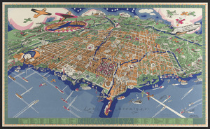
An illustrated map of Chicago : youthful city of the big shoulders, restless, ingenious, wilful, violent, proud to be alive!
2782.
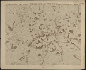
Illustrated map of London, or stranger's guide to the public buildings, theatres, music halls, & and all places of interest
2783.
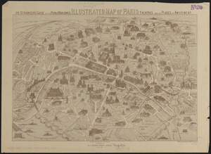
Illustrated map of Paris : or stranger's guide to the public buildings, theatres, and all places of amusement
2784.
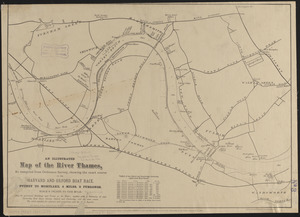
An illustrated map of the River Thames, as compiled from Ordnance Survey, showing the exact course of the Harvard and Oxford...
2785.
Illustrated map of the route of Transcontinental Air Transport, Inc.
2786.
Illustrated Times map of North America
2787.
Illustration of a building at 290 Tremont St. in Boston
2788.
Illustration of the south side of Boylston Street between Clarendon and Berkeley Streets
2789.
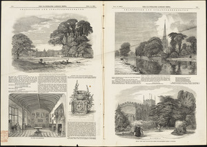
Illustrations of Charlecote Hall, Church of the Holy Trinity, and New Place
2790.
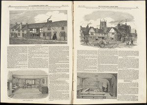
Illustrations of Shakespeare's house and school
2791.
Illustrative site plan : Government Center urban renewal area, Massachusetts R-35
2792.
Illustrative site plan : Washington Park urban renewal area, Massachusetts R-24
2793.
Illustrierte karte der Vereinigten Staaten von Amerika : mit darstellung der regionalen bodenschätze, produkte und...
2794.
Illustrissimo celsissimoque principi Carolo Emanueli D. G. Sabaudiae Duci, Pedemontii principi etc. hanc accuratam status...
2795.
Illustrissimo Celsissimoque Principii Guiljelmo Henrico D.G. Arausionum Principi Domino suo Clementissimo hanc Comitatus...
2796.
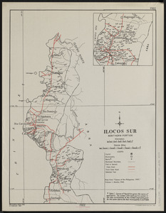
Ilocos Sur : northern portion
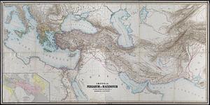
2797.
Imperia Persarum et Macedonum in usum scholarum descripta
2798.
Imperial Federation, map of the world showing the extent of the British Empire in 1886
2799.
Imperii Sinarum nova descriptio
2800.
An improved map of the United States
+
-
Redo search here
Search when I move the map
Leaflet
| ©
OpenStreetMap
contributors, ©
CartoDB
‹ Prev
Next ›
1
2
…
136
137
138
139
140
141
142
143
144
…
435
436