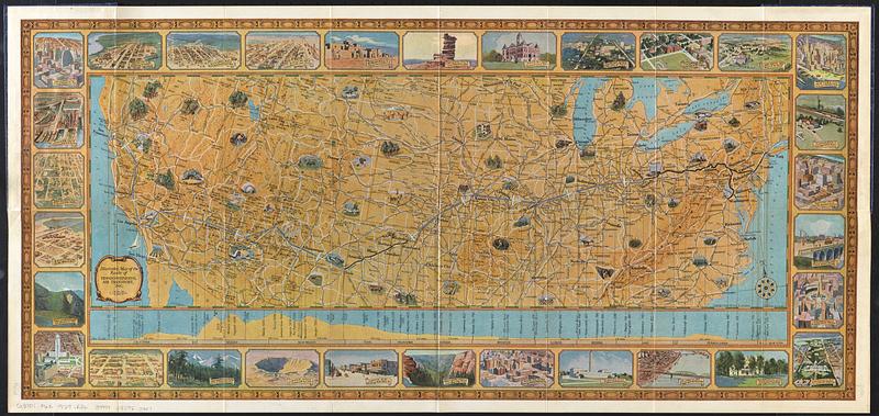
Illustrated map of the route of Transcontinental Air Transport, Inc.

Item Information
- Title:
- Illustrated map of the route of Transcontinental Air Transport, Inc.
- Title (alt.):
-
Coast to coast by plane and train : illustrated map
- Cartographer:
- Rand McNally and Company
- Publisher:
- Transcontinental Air Transport
- Name on Item:
-
Rand McNally & Company
- Date:
-
[1929]
- Format:
-
Maps/Atlases
- Genre:
-
Pictorial maps
- Location:
-
Boston Public Library
Norman B. Leventhal Map & Education Center - Collection (local):
-
Norman B. Leventhal Map & Education Center Collection
- Subjects:
-
United States--Maps
Airways--United States--Maps
Transcontinental Air Transport
- Places:
-
United States
- Extent:
- 1 map : color ; 22 x 66, on sheet 38 x 81 cm, folded in covers 20 x 11 cm
- Terms of Use:
-
No known copyright restrictions.
No known restrictions on use.
- Publisher:
-
[New York] :
Transcontinental Air Transport
- Scale:
-
Scale approximately 1:6,000,000
- Language:
-
English
- Notes:
-
Relief shown by shading.
Shows route from New York and Washington to Los Angeles and San Francisco.
Includes vertical profile.
Views and illustrations of 30 cities and landmarks in border around map.
"7134 New York 6-29."
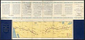
Verso: Descriptive text, map showing extent of the TAT weather bureau, and flight log.
Boston Public Library copy has certificate of flight and flight log recorded for Mr. Norman Swan on August 8th, 1929.
- Notes (date):
-
This date is inferred.
- Identifier:
-
06_01_017974
06_01_017975
- Call #:
-
G3701.P62 1929 .R36
- Barcode:
-
39999085952917


