Toggle navigation
LMEC Home
Exhibitions
Georeferencing
Tools for Teachers
Collections
My Favorites
Sign Up / Log In
Search
Search the map portal
Map Collection
Map Collection
Map Sets
Search
Search
Search for
Search In
All Fields
Creator
Title
Subject
Place
Search All Digital Collections
Advanced Search
8995 Results
My Search
Start Over
More Like
commonwealth:tt44pv95m
Remove constraint More Like: commonwealth:tt44pv95m
Filter your Search
Place
North and Central America
6,226
United States
5,142
Massachusetts
2,145
Europe
1,396
Suffolk (county)
1,341
Boston
1,314
Canada
449
Asia
438
more
Place
»
Topic
Boston (Mass.)--Maps
752
United States--Maps
282
City planning--Massachusetts--Boston--Maps
253
Real property--Massachusetts--Boston--Maps
253
Landowners--Massachusetts--Boston--Maps
169
Massachusetts--Maps
166
Urban renewal--Massachusetts--Boston--Maps
150
New England--Maps
104
more
Topic
»
Date
Date range begin
–
Date range end
Current results range from
1482
to
2023
View distribution
Creator
United States. Hydrographic Office
595
Boston Redevelopment Authority
256
O.H. Bailey & Co
148
Des Barres, Joseph F. W. (Joseph Frederick Wallet), 1722-1824
124
United States. Post Office Dept
120
Ptolemy, 2nd cent
100
Walling, Henry Francis, 1825-1888
94
Geological Survey (U.S.)
87
more
Creator
»
Format
Maps/Atlases
8,935
Manuscripts
215
Prints
56
Books
36
Objects/Artifacts
10
Drawings/Illustrations
8
Posters
5
Georeferenced
Yes
886
No
8,109
Collection
Norman B. Leventhal Map & Education Center Collection
8,725
Boston and New England Maps
2,465
Urban Maps
2,248
Maritime Charts and Atlases
1,083
American Revolutionary War-Era Maps
638
Boston Redevelopment Authority Collection
297
Massachusetts Real Estate Atlases
38
Mapping Boston Collection
20
more
Collection
»
Available to use
No known restrictions
8,772
Creative Commons license
70
Search Constraints
Sort by relevance
relevance
title
date (asc)
date (desc)
Number of results to display per page
20 per page
10
per page
20
per page
50
per page
100
per page
View results as:
grid view
map view
Search Results
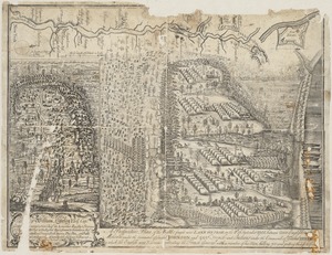
7281.
A prospective plan of the battle fought near Lake George on the 8th of September, 1755 between 2000 English with 250 Mohawks...
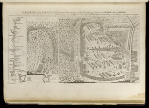
7282.
A prospective view of the battle fought near Lake George, on the 8th of Sepr. 1755, between 2000 English, with 250 Mohawks,...
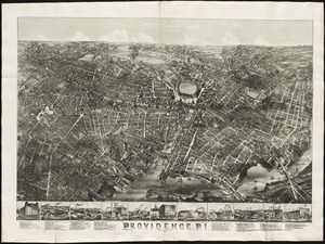
7283.
Providence, R.I
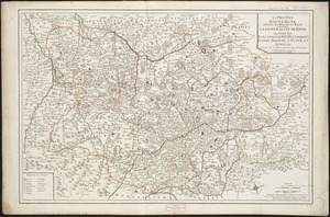
7284.
La province d'Auvergne divisée en haute et basse : la generalité de Riom ou sont les elections de Riom, Clermont, Issoire,...
7285.
Province of Maine
7286.
The province of Maine, from the best authorities
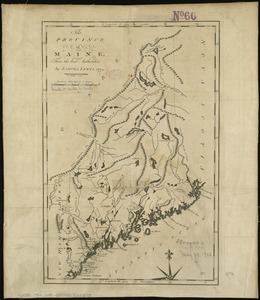
7287.
The province of Maine, from the best authorities
7288.
The province of New Jersey, divided into east and west, commonly called the Jerseys
7289.
The province of New Jersey, divided into east and west, commonly called the Jerseys
7290.
Les provinces des Pays-Bas Catholiques ou A most exact map of Flanders or ye Austrian Netherlands &c : it comprehends all the...
7291.
The provinces of New York and New Jersey : with part of Pensilvania, and the Province of Quebec
7292.
The provinces of New York, and New Jersey; with part of Pensilvania, and the governments of Trois Rivieres, and Montreal
7293.
Provincetown Harbor
7294.
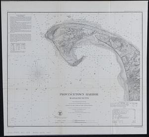
Provincetown Harbor, Massachusetts : from a trigonometrical survey under the direction of A.D. Bache Superintendent of the...
7295.
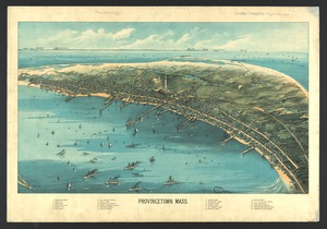
Provincetown, Mass
7296.
Provincia = Provence
7297.
Provincia de Santa Fé registro gráfico : construido con los datos recopilados por la dirección de Obras Públicas y Geodesia...
7298.
Provinciae, regionis Galliae, vera exactissimaque descriptio
7299.
Prussia
7300.
Prussia
‹ Prev
Next ›
1
2
…
361
362
363
364
365
366
367
368
369
…
449
450