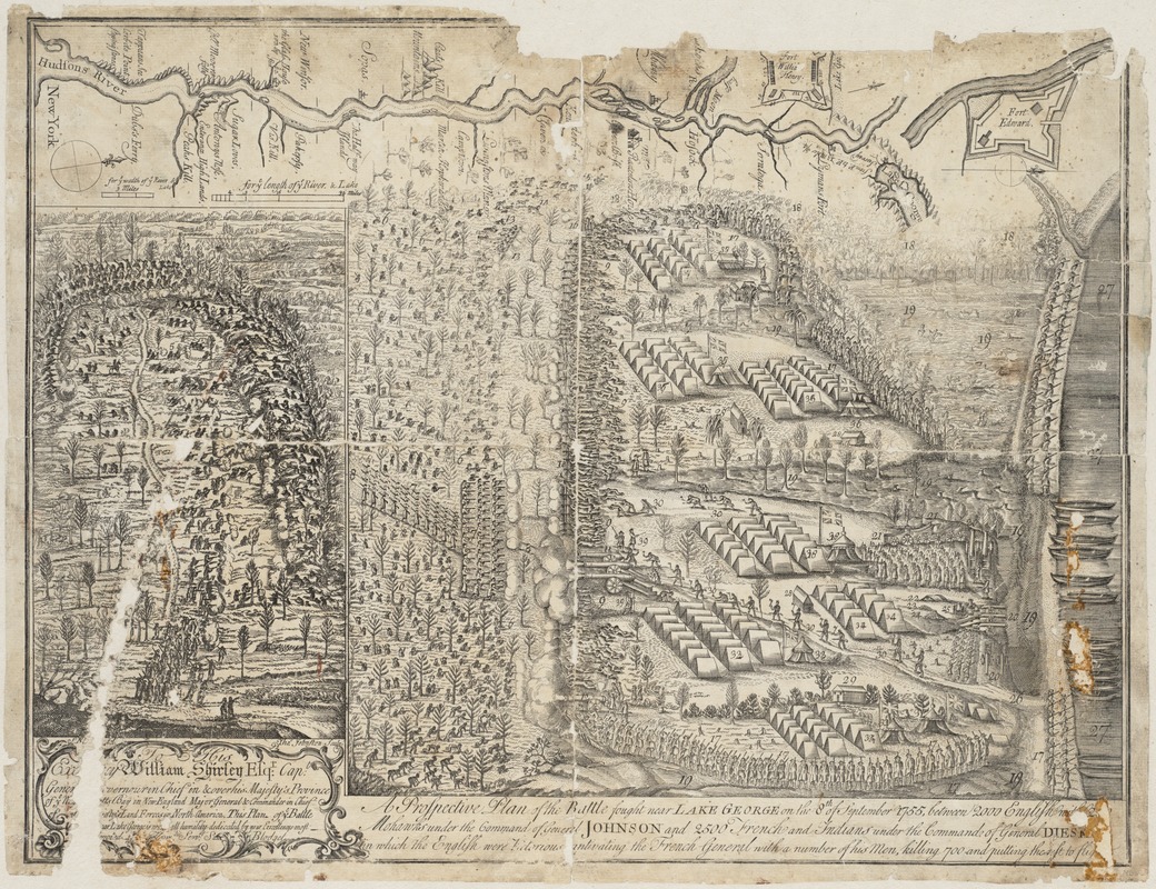
A prospective plan of the battle fought near Lake George on the 8th of September, 1755 between 2000 English with 250 Mohawks under the command of General Johnson and 2500 French and Indians under the command of General Dieskau in which the English were victorious, captivating the French General with a number of his men, killing 700 and putting the rest to flight
This map is also available in American Revolutionary Geographies Online (ARGO), a collections portal especially built for material relating to the American Revolutionary War Era. Visit ARGO to learn more about this item and explore the historical geography of North America in the late eighteenth century.
Item Information
- Title:
- A prospective plan of the battle fought near Lake George on the 8th of September, 1755 between 2000 English with 250 Mohawks under the command of General Johnson and 2500 French and Indians under the command of General Dieskau in which the English were victorious, captivating the French General with a number of his men, killing 700 and putting the rest to flight
- Description:
-
In late summer 1755, a force of colonial militia advanced up the Hudson River with the goal of capturing the French fortress of Saint Frederic on Lake Champlain. Near Lake George they were ambushed by a large force of French and Indians and suffered terrible losses. The enemy was eventually forced to retreat, allowing the colonials to claim victory even though they abandoned the campaign against Fort Saint Frederic. This remarkable plan was drawn by Samuel Blodget of Haverhill, Massachsuetts, who probably served as a sutler (supplier of food and other necessities) to the militia.
- Creator:
- Blodget, Samuel, 1724-1807
- Name on Item:
-
S. Blodget del. ; Thos. Johnston sculps.
- Date:
-
[1755]
- Format:
-
Maps/Atlases
- Location:
-
Boston Public Library
Norman B. Leventhal Map & Education Center - Collection (local):
-
Norman B. Leventhal Map & Education Center Collection
- Subjects:
-
Lake George, Battle of, N.Y., 1755--Maps--Early works to 1800
George, Lake (N.Y. : Lake)--Maps--Early works to 1800
- Places:
-
New YorkGeorge, Lake
- Extent:
- 1 map ; 34 x 45 cm.
- Terms of Use:
-
No known copyright restrictions.
No known restrictions on use.
- Publisher:
-
Boston, Mass :
s.n.
- Scale:
-
Scale not given.
- Language:
-
English
- Notes:
-
Oriented with north toward the upper right.
Relief shown pictorially.
Contains two battle scenes and a map of the Hudson River.
Said to have been "without doubt printed and engraved in Boston, by Thomas Johnston."
- Notes (date):
-
This date is inferred.
- Identifier:
-
06_01_004018
- Call #:
-
G3802.G4S26 1755 .B5
- Barcode:
-
39999059003499


