Toggle navigation
LMEC Home
Exhibitions
Georeferencing
Tools for Teachers
Collections
My Favorites
Sign Up / Log In
Search
Search the map portal
Map Collection
Map Collection
Map Sets
Search
Search
Search for
Search In
All Fields
Creator
Title
Subject
Place
Search All Digital Collections
Advanced Search
429 Results
My Search
Start Over
More Like
commonwealth:th83pm653
Remove constraint More Like: commonwealth:th83pm653
Filter your Search
Place
North and Central America
380
United States
257
North America
68
Pennsylvania
66
Canada
59
New York
30
New Jersey
21
Asia
17
more
Place
»
Topic
North America--Maps--Early works to 1800
59
Pennsylvania--Maps
50
United States--Maps--Early works to 1800
43
Canada--Maps--Early works to 1800
38
New Jersey--Maps
16
Great Lakes Region (North America)--Maps--Early works to 1800
12
Maryland--Maps
12
New York (State)--Maps
12
more
Topic
»
Date
Date range begin
–
Date range end
Current results range from
1623
to
1999
View distribution
Creator
Jefferys, Thomas, -1771
19
Bellin, Jacques Nicolas, 1703-1772
16
Gibson, J. (John), active 1750-1792
15
Robert Sayer and John Bennett (Firm)
14
Carleton, Osgood, 1742-1816
13
Faden, William, 1749-1836
13
Carey, Mathew, 1760-1839
12
Bowles, Carington, 1724-1793
10
more
Creator
»
Format
Maps/Atlases
427
Manuscripts
4
Paintings
3
Ephemera
1
Objects/Artifacts
1
Prints
1
Georeferenced
Yes
7
No
422
Collection
MacLean Collection Map Library
379
American Revolutionary War-Era Maps
354
Norman B. Leventhal Map & Education Center Collection
27
William L. Clements Library Collection
19
American Antiquarian Society Collection
4
Urban Maps
1
Available to use
No known restrictions
27
Search Constraints
Sort by relevance
relevance
title
date (asc)
date (desc)
Number of results to display per page
20 per page
10
per page
20
per page
50
per page
100
per page
View results as:
grid view
map view
Search Results
41.
Rail road map of Pennsylvania
42.
Rail road map of Pennsylvania
43.
Seat of war in the environs of Philadelphia
44.
Sketch from information of the different roads about Freehold in the Jerseys
45.
A sketch of the several Indian roads leading from Fort Pitt to Sioto, Lake Erie &c. : takn. from a draft (made on a tour thro'...
46.
Sketch showing a feasible canal route, Allegheny River to Lake Erie.
47.
The state of Pennsylvania : reduced with permission from Reading Howells map
48.
A survey of the empire group : with a complete distance table, a compendious index of cities and post offices, with populations...
49.
A survey of the empire group : with a complete distance table, a compendious index of cities and post offices, with populations...
50.
The tourist's pocket map of Pennsylvania : exhibiting its internal improvements, roads, distances, &c
51.
1.st sheet of De Witt's state-map of New-York
52.
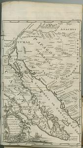
An accurate map of California drawn by the society of Jesuits, & dedicated to the king of Spain
53.
An accurate map of His Majesty's province of New Hampshire in New England, taken from actual surveys of all the inhabited part,...
54.
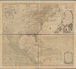
An accurate map of North America describing and distinguishing the British, Spanish and French dominions on this great...
55.
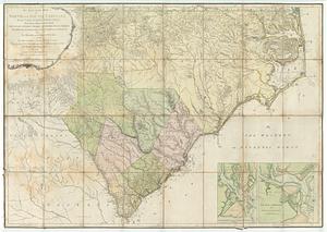
An accurate map of North and South Carolina with their Indian frontiers : shewing in a distinct manner all the mountains,...
56.
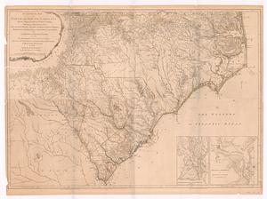
An accurate map of North and South Carolina with their Indian frontiers, shewing in a distinct manner all the mountains,...
57.
An accurate map of the commonwealth of Massachusetts exclusive of the district of Maine compiled pursuant to an act of the...
58.
An accurate map of the commonwealth of Massachusetts exclusive of the district of Maine compiled pursuant to an act of the...
59.
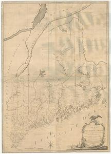
An accurate map, of the district of Maine being part of the commonwealth of Massachusetts : compiled pursuant to an act of the...
60.
An accurate map, of the district of Maine being part of the commonwealth of Massachusetts : compiled pursuant to an act of the...
‹ Prev
Next ›
1
2
3
4
5
6
7
…
21
22