Toggle navigation
LMEC Home
Exhibitions
Georeferencing
Tools for Teachers
Collections
My Favorites
Sign Up / Log In
Search
Search the map portal
Map Collection
Map Collection
Map Sets
Search
Search
Search for
Search In
All Fields
Creator
Title
Subject
Place
Search All Digital Collections
Advanced Search
9088 Results
My Search
Start Over
More Like
commonwealth:t722mh264
Remove constraint More Like: commonwealth:t722mh264
Filter your Search
Place
North and Central America
6,319
United States
5,237
Massachusetts
2,151
Suffolk (county)
1,439
Boston
1,412
Europe
1,396
Canada
449
Asia
438
more
Place
»
Topic
Boston (Mass.)--Maps
685
City planning--Massachusetts--Boston--Maps
418
United States--Maps
282
Real property--Massachusetts--Boston--Maps
253
Urban renewal--Massachusetts--Boston--Maps
253
Landowners--Massachusetts--Boston--Maps
169
Massachusetts--Maps
162
Buildings--Massachusetts--Boston--Maps
124
more
Topic
»
Date
Date range begin
–
Date range end
Current results range from
1482
to
2023
View distribution
Creator
United States. Hydrographic Office
595
Boston Redevelopment Authority
392
O.H. Bailey & Co
148
Des Barres, Joseph F. W. (Joseph Frederick Wallet), 1722-1824
123
United States. Post Office Dept
120
Ptolemy, 2nd cent
100
Walling, Henry Francis, 1825-1888
94
Geological Survey (U.S.)
86
more
Creator
»
Format
Maps/Atlases
9,028
Manuscripts
215
Prints
56
Books
36
Objects/Artifacts
10
Drawings/Illustrations
8
Posters
5
Georeferenced
Yes
869
No
8,219
Collection
Norman B. Leventhal Map & Education Center Collection
8,695
Boston and New England Maps
2,591
Urban Maps
2,379
Maritime Charts and Atlases
1,083
American Revolutionary War-Era Maps
616
Boston Redevelopment Authority Collection
445
Massachusetts Real Estate Atlases
35
Applied Geographics, Inc. Records
1
Available to use
No known restrictions
8,911
Creative Commons license
47
Search Constraints
Sort by relevance
relevance
title
date (asc)
date (desc)
Number of results to display per page
20 per page
10
per page
20
per page
50
per page
100
per page
View results as:
grid view
map view
Search Results
6921.
Plan of the town of Boston, with the attack on Bunkers-Hill, in the peninsula of Charlestown, the 17th of June, 1775
6922.
Plan of the town of Boston with the attack on Bunkers-Hill in the peninsula of Charlestown the 17th of June 1775
6923.
Plan of the town of Brighton
6924.
Plan of the town of Cayenne and Fort St. Michael
6925.
Plan of the town of Dorchester
6926.
Plan of the town of Lowell and Belvidere Village
6927.
Plan of the town of Meriden, New Haven County, Connecticut
6928.
Plan of the town of Millbury : Worcester Co. Mass. : from recent and actual surveys
6929.
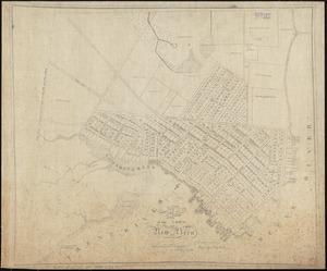
A plan of the town of New Bern
6930.
A plan of the town of New Haven : with all the buildings in 1748 taken by the Hon. Gen. Wadsworth of Durham to which are added...
6931.
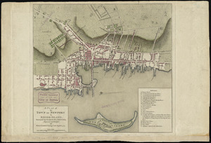
A plan of the town of Newport in Rhode Island
6932.
A plan of the town of Newport in the province of Rhode Island
6933.
A plan of the town of Newport in the province of Rhode Island
6934.
Plan of the town of Quebec, the capital of Canada in North America, with the Bason and a part of the adjacent country shewing...
6935.
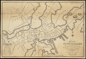
Plan of the town of Salem in the commonwealth of Massachusetts : from actual surveys, made in the years 1796 & 1804; with the...
6936.
A plan of the town of Walpole taken by an actual survey in the month of October 1794 and layed down from a scale of 200 rods to...
6937.
Plan of the town of West Roxbury : compiled from various plans and surveys, by order of the selectmen
6938.
Plan of the town, road, and harbour of Chagre ; Plan of Porto Belo
6939.
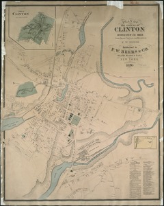
Plan of the towns of Clinton, Worcester Co. Mass : from recent surveys and records
6940.
Plan of the towns of Sturbridge and Southbridge : from actual surveys and records
‹ Prev
Next ›
1
2
…
343
344
345
346
347
348
349
350
351
…
454
455